Albion, Washington
Albion is a town in Whitman County, Washington, United States. The population was 579 at the 2010 census.
Albion | |
|---|---|
.jpg.webp) Welcome sign | |
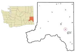 Location of Albion, Washington | |
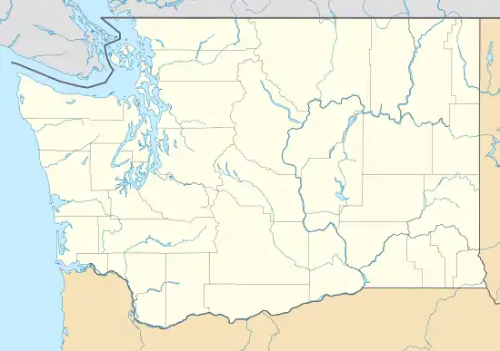 Albion Location of Albion, Washington  Albion Albion (the United States)  Albion Albion (North America) | |
| Coordinates: 46°47′33″N 117°15′2″W | |
| Country | United States |
| State | Washington |
| County | Whitman |
| Area | |
| • Total | 0.39 sq mi (1.02 km2) |
| • Land | 0.39 sq mi (1.02 km2) |
| • Water | 0.00 sq mi (0.00 km2) |
| Elevation | 2,247 ft (685 m) |
| Population | |
| • Total | 579 |
| • Estimate (2019)[3] | 604 |
| • Density | 1,540.82/sq mi (594.35/km2) |
| Time zone | UTC-8 (Pacific (PST)) |
| • Summer (DST) | UTC-7 (PDT) |
| ZIP code | 99102 |
| Area code | 509 |
| FIPS code | 53-01010 |
| GNIS feature ID | 1511954[4] |
| Website | www |
History
Albion was first settled in 1871 by Levi Reynolds, and was platted in 1883.[5] The town was known as Guy, until 1901, when a resident insisted to change the town's name to honor Sir Francis Drake, who named the region Nova Albion (New England).[6][7] Albion was officially incorporated on March 4, 1910.
Geography
According to the United States Census Bureau, the town has a total area of 0.36 square miles (0.93 km2), all of it land.[8]
Climate
This region experiences warm (but not hot) and dry summers, with no average monthly temperatures above 71.6 °F. According to the Köppen Climate Classification system, Albion has a warm-summer Mediterranean climate, abbreviated "Csb" on climate maps.[9]
Demographics
| Historical population | |||
|---|---|---|---|
| Census | Pop. | %± | |
| 1910 | 276 | — | |
| 1920 | 252 | −8.7% | |
| 1930 | 236 | −6.3% | |
| 1940 | 206 | −12.7% | |
| 1950 | 256 | 24.3% | |
| 1960 | 291 | 13.7% | |
| 1970 | 687 | 136.1% | |
| 1980 | 631 | −8.2% | |
| 1990 | 632 | 0.2% | |
| 2000 | 616 | −2.5% | |
| 2010 | 579 | −6.0% | |
| 2019 (est.) | 604 | [3] | 4.3% |
| U.S. Decennial Census[10] | |||
2010 census
As of the census[2] of 2010, there were 579 people, 271 households, and 154 families living in the town. The population density was 1,608.3 inhabitants per square mile (621.0/km2). There were 302 housing units at an average density of 838.9 per square mile (323.9/km2). The racial makeup of the town was 92.4% White, 0.7% African American, 0.5% Native American, 1.0% Asian, 0.5% from other races, and 4.8% from two or more races. Hispanic or Latino of any race were 3.1% of the population.
There were 271 households, of which 29.5% had children under the age of 18 living with them, 40.6% were married couples living together, 10.7% had a female householder with no husband present, 5.5% had a male householder with no wife present, and 43.2% were non-families. 34.7% of all households were made up of individuals, and 7% had someone living alone who was 65 years of age or older. The average household size was 2.14 and the average family size was 2.73.
The median age in the town was 37.2 years. 23.7% of residents were under the age of 18; 7.1% were between the ages of 18 and 24; 29% were from 25 to 44; 30.7% were from 45 to 64; and 9.5% were 65 years of age or older. The gender makeup of the town was 49.4% male and 50.6% female.
2000 census
As of the 2000 census, there were 616 people, 274 households, and 166 families living in the town. The population density was 1,663.4 people per square mile (642.8/km2). There were 315 housing units at an average density of 850.6 per square mile (328.7/km2). The racial makeup of the town was 93.51% White, 0.16% African American, 0.49% Native American, 0.65% Asian, 1.46% Pacific Islander, 1.79% from other races, and 1.95% from two or more races. Hispanic or Latino of any race were 3.25% of the population.
There were 274 households, out of which 26.3% had children under the age of 18 living with them, 51.5% were married couples living together, 6.9% had a female householder with no husband present, and 39.4% were non-families. 28.8% of all households were made up of individuals, and 4.7% had someone living alone who was 65 years of age or older. The average household size was 2.25 and the average family size was 2.81.
In the town, the age distribution of the population shows 21.8% under the age of 18, 12.3% from 18 to 24, 33.9% from 25 to 44, 22.7% from 45 to 64, and 9.3% who were 65 years of age or older. The median age was 34 years. For every 100 females, there were 94.3 males. For every 100 females age 18 and over, there were 88.3 males.
The median income for a household in the town was $40,179, and the median income for a family was $45,893. Males had a median income of $28,250 versus $23,828 for females. The per capita income for the town was $19,567. About 11.7% of families and 15.8% of the population were below the poverty line, including 32.8% of those under age 18 and none of those age 65 or over.
References
- "2019 U.S. Gazetteer Files". United States Census Bureau. Retrieved August 7, 2020.
- "U.S. Census website". United States Census Bureau. Retrieved 2012-12-19.
- "Population and Housing Unit Estimates". United States Census Bureau. May 24, 2020. Retrieved May 27, 2020.
- "US Board on Geographic Names". United States Geological Survey. 2007-10-25. Retrieved 2008-01-31.
- Majors, Harry M. (1975). Exploring Washington. Van Winkle Publishing Co. p. 143. ISBN 978-0-918664-00-6.
- Phillips, James W. (1997). Washington State Place Names (8th ed.). University of Washington Press. p. 5. ISBN 0-295-95498-1.
- Meany, Edmond S. (1923). Origin of Washington geographic names. Seattle: University of Washington Press. p. 3.
- "US Gazetteer files 2010". United States Census Bureau. Archived from the original on 2012-01-25. Retrieved 2012-12-19.
- Climate Summary for Albion, Washington
- United States Census Bureau. "Census of Population and Housing". Retrieved October 11, 2013.
External links
Municipalities and communities of Whitman County, Washington, United States | ||
|---|---|---|
| Cities | 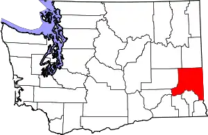 Map of Washington highlighting Whitman County | |
| Towns | ||
| CDP | ||
| Other unincorporated communities | ||
| Ghost towns | ||
| ||
| Authority control |
|---|