Alkaleri
Alkaleri is a Local Government Area of Bauchi State, Nigeria. Its headquarters are in the town of Alkaleri (or Alkalere) on the A345 highway in the north of the area at10°15′58″N 10°20′07″E. The northeasterly line of equal latitude and longitude passes through the LGA.
Alkaleri | |
|---|---|
LGA and town | |
 Alkaleri Location in Nigeria | |
| Coordinates: 9°53′N 10°30′E | |
| Country | |
| State | Bauchi State |
| Area | |
| • Total | 5,918 km2 (2,285 sq mi) |
| Population (2006 census) | |
| • Total | 329,424 |
| Time zone | UTC+1 (WAT) |
| 3-digit postal code prefix | 743 |
| ISO 3166 code | NG.BA.AL |
It has an area of 5,918 km2 and a population of 329,424 at the 2006 census.
The predominant ethnic group in the area are the fulani, Kanuri, Dugurawa, Guruntawa and Labur "Jaku" people.[1]
The postal code of the area is 743.[2]
Districts
The districts of the local government are Pali, Duguri, and Gwana. Major towns and villages of the local government like Fanti, Gar, Gokaru, Guma, Gwaram etc. including the local government headquarters, Alkaleri are located in Pali district. Duguri district is the home to Yankari -West Africa's premiere game reserve, and consists of towns and villages like Badara, Dagudi, Dan, Gajin Duguri, Mainamaji, Yashi, Yelwan Duguri, and the historic Duguri. Gwana is located at the south-eastern part of the local government.
References
- "State maps". Nigerian National Bureau of Statistics. Archived from the original on 1 May 2010. Retrieved 2010-05-19.
- "Post Offices- with map of LGA". NIPOST. Archived from the original on 7 October 2009. Retrieved 2009-10-20.
State capital: Bauchi | ||
| Local Government Areas | 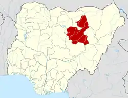 | |