Allenhurst, Georgia
Allenhurst is a city in Liberty County, Georgia, United States. It is a part of the Hinesville-Fort Stewart metropolitan statistical area. As of the 2010 census, the city had a population of 695.[5]
Allenhurst, Georgia | |
|---|---|
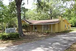 Allenhurst Town Hall | |
 Location in Liberty County and the state of Georgia | |
| Coordinates: 31°46′53″N 81°36′30″W | |
| Country | United States |
| State | Georgia |
| County | Liberty |
| Area | |
| • Total | 1.14 sq mi (2.94 km2) |
| • Land | 1.09 sq mi (2.84 km2) |
| • Water | 0.04 sq mi (0.11 km2) |
| Elevation | 59 ft (18 m) |
| Population (2010) | |
| • Total | 695 |
| • Estimate (2019)[2] | 716 |
| • Density | 653.88/sq mi (252.48/km2) |
| Time zone | UTC-5 (Eastern (EST)) |
| • Summer (DST) | UTC-4 (EDT) |
| ZIP code | 31301 |
| Area code(s) | 912 |
| FIPS code | 13-01472[3] |
| GNIS feature ID | 0310462[4] |
History
Allenhurst was platted in 1910 by B. H. Allen, the proprietor of a local sawmill.[6] A post office has been in operation since 1909.[7]
Geography
Allenhurst is located at 31°46′53″N 81°36′30″W (31.781311, -81.608470).[8]
According to the United States Census Bureau, the town has a total area of 1.1 square miles (2.8 km2), of which 1.1 square miles (2.8 km2) is land and 0.88% is water.
Demographics
| Historical population | |||
|---|---|---|---|
| Census | Pop. | %± | |
| 1970 | 230 | — | |
| 1980 | 606 | 163.5% | |
| 1990 | 594 | −2.0% | |
| 2000 | 788 | 32.7% | |
| 2010 | 695 | −11.8% | |
| 2019 (est.) | 716 | [2] | 3.0% |
| U.S. Decennial Census[9] | |||
As of the 2010 United States Census, there were 695 people living in the city. The racial makeup of the city was 45.2% White, 43.0% Black, 2.3% Asian, 1.0% Pacific Islander and 2.7% from two or more races. 5.8% were Hispanic or Latino of any race.
As of the census[3] of 2000, there were 788 people, 281 households, and 202 families living in the town. The population density was 694.3 people per square mile (269.2/km2). There were 326 housing units at an average density of 287.2 per square mile (111.4/km2). The racial makeup of the town was 49.87% White, 44.16% African American, 0.51% Native American, 0.63% Asian, 0.25% Pacific Islander, 1.27% from other races, and 3.30% from two or more races. Hispanic or Latino of any race were 5.20% of the population.
There were 281 households, out of which 43.4% had children under the age of 18 living with them, 53.0% were married couples living together, 14.9% had a female householder with no husband present, and 28.1% were non-families. 18.1% of all households were made up of individuals, and 3.2% had someone living alone who was 65 years of age or older. The average household size was 2.80 and the average family size was 3.12.
In the town, the population was spread out, with 31.6% under the age of 18, 14.8% from 18 to 24, 33.2% from 25 to 44, 14.1% from 45 to 64, and 6.2% who were 65 years of age or older. The median age was 27 years. For every 100 females, there were 105.7 males. For every 100 females age 18 and over, there were 106.5 males.
The median income for a household in the town was $38,750, and the median income for a family was $40,536. Males had a median income of $25,972 versus $19,688 for females. The per capita income for the town was $14,501. About 12.2% of families and 12.5% of the population were below the poverty line, including 15.8% of those under age 18 and none of those age 65 or over.
Government and infrastructure

The United States Postal Service operates the Allenhurst Post Office.[10]
Education
The Liberty County School District operates public schools that serve Allenhurst.
References
- "2019 U.S. Gazetteer Files". United States Census Bureau. Retrieved July 9, 2020.
- "Population and Housing Unit Estimates". United States Census Bureau. May 24, 2020. Retrieved May 27, 2020.
- "U.S. Census website". United States Census Bureau. Retrieved 2008-01-31.
- "US Board on Geographic Names". United States Geological Survey. 2007-10-25. Retrieved 2008-01-31.
- Bureau, U.S. Census. "American FactFinder - Results". factfinder2.census.gov. Archived from the original on 2020-02-12.
- Krakow, Kenneth K. (1975). Georgia Place-Names: Their History and Origins (PDF). Macon, GA: Winship Press. p. 3. ISBN 0-915430-00-2.
- "Post Offices". Jim Forte Postal History. Retrieved 31 March 2018.
- "US Gazetteer files: 2010, 2000, and 1990". United States Census Bureau. 2011-02-12. Retrieved 2011-04-23.
- "Census of Population and Housing". Census.gov. Retrieved June 4, 2015.
- "ALLENHURST." U.S. Postal Service. Retrieved on May 9, 2017.
Municipalities and communities of Liberty County, Georgia, United States | ||
|---|---|---|
| Cities | 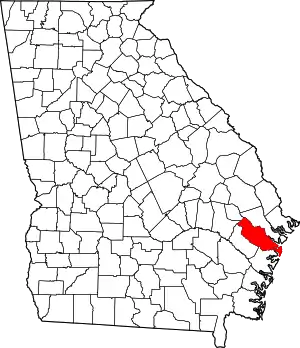 Map of Georgia highlighting Liberty County | |
| CDP | ||
| Unincorporated communities | ||
| Ghost towns | ||
| ||