Allison, Iowa
Allison is a city in, and the county seat of, Butler County, Iowa, United States.[5] The population was 1,029 at the 2010 census. Allison is home to the Butler County Fair.[6] The city was named for U.S. Senator William B. Allison in 1881.[7]
Allison, Iowa | |
|---|---|
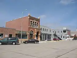 Downtown Allison, Iowa, March 2008 | |
 Location of Allison, Iowa | |
| Coordinates: 42°45′12″N 92°47′41″W | |
| Country | |
| State | |
| County | Butler |
| Government | |
| • Type | Municipal city |
| • Mayor | Scot Henrichs[1] |
| Area | |
| • Total | 2.93 sq mi (7.59 km2) |
| • Land | 2.93 sq mi (7.59 km2) |
| • Water | 0.00 sq mi (0.00 km2) |
| Elevation | 1,053 ft (321 m) |
| Population | |
| • Total | 1,029 |
| • Estimate (2019)[4] | 973 |
| • Density | 331.97/sq mi (128.16/km2) |
| Time zone | UTC-6 (Central (CST)) |
| • Summer (DST) | UTC-5 (CDT) |
| ZIP code | 50602 |
| Area code(s) | 319 |
| FIPS code | 19-01315 |
| GNIS feature ID | 0454143 |
| Website | www |
Geography
Allison's longitude and latitude coordinates in decimal form are 42.753466, -92.794599.[8]
According to the United States Census Bureau, the city has a total area of 2.93 square miles (7.59 km2), all land.[9]
Demographics
| Year | Pop. | ±% |
|---|---|---|
| 1900 | 463 | — |
| 1910 | 495 | +6.9% |
| 1920 | 520 | +5.1% |
| 1930 | 603 | +16.0% |
| 1940 | 708 | +17.4% |
| 1950 | 771 | +8.9% |
| 1960 | 952 | +23.5% |
| 1970 | 1,071 | +12.5% |
| 1980 | 1,132 | +5.7% |
| 1990 | 1,000 | −11.7% |
| 2000 | 1,006 | +0.6% |
| 2010 | 1,029 | +2.3% |
| 2019 | 973 | −5.4% |
| Source: "U.S. Census website". United States Census Bureau. Retrieved 2020-03-28. Source: | ||
2010 census
As of the census[3] of 2010, there were 1,029 people, 440 households, and 277 families living in the city. The population density was 351.2 inhabitants per square mile (135.6/km2). There were 470 housing units at an average density of 160.4 per square mile (61.9/km2). The racial makeup of the city was 99.4% White, 0.1% Asian, and 0.5% from two or more races. Hispanic or Latino people of any race were 0.2% of the population.
There were 440 households, of which 25.9% had children under the age of 18 living with them, 53.4% were married couples living together, 6.4% had a female householder with no husband present, 3.2% had a male householder with no wife present, and 37.0% were non-families. 32.3% of all households were made up of individuals, and 19.6% had someone living alone who was 65 years of age or older. The average household size was 2.22 and the average family size was 2.77.
The median age in the city was 46.4 years. 21.9% of residents were under the age of 18; 6.4% were between the ages of 18 and 24; 20.3% were from 25 to 44; 25.1% were from 45 to 64; and 26.2% were 65 years of age or older. The gender makeup of the city was 46.6% male and 53.4% female.
2000 census
As of the census[11] of 2000, there were 1,006 people, 424 households, and 267 families living in the city. The population density was 341.2 people per square mile (131.7/km2). There were 454 housing units at an average density of 154.0 per square mile (59.4/km2). The racial makeup of the city was 99.50% White, 0.10% from other races, and 0.40% from two or more races. Hispanic or Latino people of any race were 0.30% of the population.
There were 424 households, out of which 25.9% had children under the age of 18 living with them, 55.4% were married couples living together, 6.1% had a female householder with no husband present, and 36.8% were non-families. 33.0% of all households were made up of individuals, and 23.1% had someone living alone who was 65 years of age or older. The average household size was 2.20 and the average family size was 2.81.
Age spread: 20.8% under the age of 18, 6.7% from 18 to 24, 21.7% from 25 to 44, 20.1% from 45 to 64, and 30.8% who were 65 years of age or older. The median age was 46 years. For every 100 females, there were 85.6 males. For every 100 females age 18 and over, there were 76.7 males.
The median income for a household in the city was $34,338, and the median income for a family was $42,050. Males had a median income of $30,147 versus $18,929 for females. The per capita income for the city was $16,472. About 5.8% of families and 8.9% of the population were below the poverty line, including 8.2% of those under age 18 and 11.4% of those age 65 or over.
Education
Allison is a part of the North Butler Community School District, which was established on July 1, 2011, by a merger of the Greene Community School District and Allison–Bristow Community School District.[12] The local high school is North Butler High School.
See also
References
- "Archived copy". Archived from the original on 2013-07-27. Retrieved 2013-04-12.CS1 maint: archived copy as title (link)
- "2019 U.S. Gazetteer Files". United States Census Bureau. Retrieved July 17, 2020.
- "U.S. Census website". United States Census Bureau. Retrieved 2012-05-11.
- "Population and Housing Unit Estimates". United States Census Bureau. May 24, 2020. Retrieved May 27, 2020.
- "Find a County". National Association of Counties. Archived from the original on 2011-05-31. Retrieved 2011-06-07.
- "2008 Calendar of Events". Retrieved 2009-02-23.
- "History of Butler County". Butler County, Iowa. Archived from the original on 2007-11-11. Retrieved 2008-01-18.
- "US Gazetteer files: 2010, 2000, and 1990". United States Census Bureau. 2011-02-12. Retrieved 2011-04-23.
- "US Gazetteer files 2010". United States Census Bureau. Archived from the original on 2012-01-25. Retrieved 2012-05-11.
- "Census of Population and Housing". Census.gov. Retrieved June 4, 2015.
- "U.S. Census website". United States Census Bureau. Retrieved 2008-01-31.
- "District Reorganization History final Archived 2019-02-09 at the Wayback Machine." Iowa Department of Education. Retrieved on July 6, 2019.
External links
| Wikimedia Commons has media related to Allison, Iowa. |
Municipalities and communities of Butler County, Iowa, United States | ||
|---|---|---|
| Cities | Map of Iowa highlighting Butler County | |
| Townships | ||
| Unincorporated communities | ||
| Footnotes | ‡This populated place also has portions in an adjacent county or counties | |
| ||