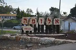
Aluma
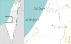
Aluma (Hebrew: אֲלֻמָּה or אלומה, lit. Sheaf) is a moshav in southern Israel. Located in the southern coastal plain around three kilometers north-west of Kiryat Gat, it falls under the jurisdiction of Shafir Regional Council. In 2019 it had a population of 537.[1]
Aluma
אֲלֻמָּה ألوما | |
|---|---|
| Hebrew transcription(s) | |
| • official | Alumma |
 | |
 Aluma | |
| Coordinates: 31°39′5″N 34°44′37″E | |
| Country | Israel |
| Council | Shafir |
| Founded | 1965 |
| Founded by | Agudat Yisrael members |
| Population (2019)[1] | 537 |
History
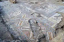
The village was established in 1965 as a youth village named Hazon Yehezkel by a group called Mosadot Hinukh Ezuri (lit. Institute for Regional Education), made up of young members of Agudat Yisrael. It was built on the ruins of the depopulated Palestinian village of Hatta.[2] In 1996 the Ministry of Interior granted the village municipal council status and renamed it Aluma. In 2014, the Israel Antiquities Authority uncovered a Byzantine-era church with a magnificent mosaic floor. The church was discovered during a salvage dig prior to the construction of a new neighborhood on the moshav.[3]
References
- "Population in the Localities 2019" (XLS). Israel Central Bureau of Statistics. Retrieved 16 August 2020.
- Khalidi, Walid (1992). All That Remains: The Palestinian Villages Occupied and Depopulated by Israel in 1948. Washington D.C.: Institute for Palestine Studies. p. 101. ISBN 0-88728-224-5. ISBN 0-88728-224-5.
- Byzantine-era church uncovered in southern Israel, Haaretz
