Ambad
Ambad is a town with a municipal council in Jalna district in the state of Maharashtra, India. Ambad is notable for its temple dedicated to the Hindu goddess Matsyodari. In October of each year, devotees of the goddess gather in Ambad for the Hindu festival of Dashahara. A local tradition claims that the name "Ambad" was given to this city by a Hindu Raja named Ambarisha. According to this tradition, Raja Ambarisha would worship the goddess on a rock hill which resembled a fish. Because of this fish-shaped rock hill, the goddess was named Matsyodari ("in the stomach of fish"). The temple was constructed by Ahilya Devi Holkar, who also has developed Ambad by constructing Pushkarini and Kavandi (water reservoirs). Ambad is the second most populous town in district of Jalna. Ambad also has a Government Polytechnic College which is one of the only two Government Polytechnic Colleges located in Jalna district along with Government Polytechnic, Jalna. Ambad municipal council is convened at Court Road. [1]
Ambad | |
|---|---|
Town | |
 Ambad Location in Maharashtra, India | |
| Coordinates: 19.62°N 75.79°E | |
| Country | |
| State | Maharashtra |
| District | Jalna |
| Elevation | 530 m (1,740 ft) |
| Population (2001) | |
| • Total | 80,352 |
| Languages | |
| • Official | Marathi |
| Time zone | UTC+5:30 (IST) |
| PIN | |
| Vehicle registration | MH-21 |
Ambad is also famous for its "Dattajayanti Sangeet Mahotsav" celebrations. The festival was started in 1923 by Pandit Bappasaheb Jalgaonkar. His son the Pandit Govindrao Jalgaonkar continued the tradition and gave it a broader appeal among masses. The festival is purely based on Indian classical music.
Villages/Cities near Ambad
- Jalna (27.0 Km)
- Pachod (20.0 Km)
- Ghansawangi (26.0 Km)
- Tirthpuri (30.0 Km)
- Shahagad (32.0 Km)
- Kumbhar Pimpalgaon (44.0 Km)
- Paithan (50.0 Km)
- Aurangabad (70.0 Km)
- Rajur (55.0 Km)
- Osmanabad (194.0 Km)
- Parbhani (128.0 Km)
- Pune (264.0 Km)
- Mumbai (427.0 Km)
- Ahmednagar (141.0 Km)
- Solapur (259.0 Km)
- Ajanta Caves (132.0 Km)
- Lonar Lake (107.0 Km)
Nearby Railway Station
Jalna (J) is nearest railway station to Ambad(28Km).
Nearby Airport
Aurangabad (IXU) is nearest airport to Ambad city which is 65 Km away from Ambad.
Education
Ambad has almost all type of well known educational institutions. Which includes, Engineering, Education (D.Ed & B.Ed), I.T.I., English medium schools and also colleges of arts, science, Computer, Management & Nursing. Few of them are mentioned below 1.Government Polytechnic College
2.Zilla Parishad School
3.Matsyodari College
4.Dattaji Bhale School
5.Omshanti Vidyalaya
6.Jain English School
7.R.P. International School
8.Matsyodari High School
9.Little Champ English School
10.Godavari College
11.CSK Jain English School
Location
Ambad is situated at distance of 28 Km from District Jalna.Ambad has extremely well developed connectivity of Roads to nearby cities like Aurangabad, Beed, Paithan & Ghansawangi. Roads are under construction while 80% of them are in complete state.One can easily connect to National Highway 52 which is just 20Km away from Ambad.And in coming time,Ambad will connect to Maharashtra Samruddhi Mahamarg aka Mumbai–Nagpur Expressway from Nidhona interchange which is just 34Km away.
Geography
Ambad is located at 19.62°N 75.79°E.[3] It has an average elevation of 530 metres (1,740 ft).
Demographics
As of the 2001 India census,[4] Ambad had a population of 80,321. Males constitute 53% of the population, and females 47%. Ambad has an average literacy rate of 65%, which is higher than the national average of 59.5%. 15% of the population is under 6 years of age.
References
- "PinCode of Ambad". citypincode.in. Retrieved 23 March 2014.
- . lokmat.com https://m.lokmat.com/aurangabad/pt-govindrao-jalgaonkar-music-festival-started/. Retrieved 27 April 2020. Missing or empty
|title=(help) - Falling Rain Genomics, Inc - Ambad
- "Census of India 2001: Data from the 2011 Census, including cities, villages and towns (Provisional)". Census Commission of India. Archived from the original on 16 June 2004. Retrieved 1 November 2008.
Jalna district topics | ||
|---|---|---|
| History | 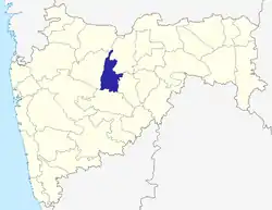 | |
| Geography | ||
| Cities and towns | ||
| Lok Sabha constituencies | ||
| Vidhan Sabha constituencies | ||
