Ambrose, Georgia
Ambrose is a city in Coffee County, Georgia, United States. As of the 2010 census, the city had a population of 380.[5]
Ambrose, Georgia | |
|---|---|
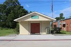 Ambrose City Hall | |
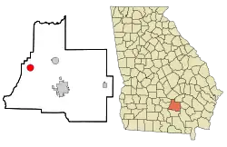 Location in Coffee County and the state of Georgia | |
| Coordinates: 31°35′38″N 83°0′57″W | |
| Country | United States |
| State | Georgia |
| County | Coffee |
| Area | |
| • Total | 3.13 sq mi (8.12 km2) |
| • Land | 3.05 sq mi (7.90 km2) |
| • Water | 0.08 sq mi (0.22 km2) |
| Elevation | 308 ft (94 m) |
| Population (2010) | |
| • Total | 380 |
| • Estimate (2019)[2] | 379 |
| • Density | 124.26/sq mi (47.97/km2) |
| Time zone | UTC-5 (Eastern (EST)) |
| • Summer (DST) | UTC-4 (EDT) |
| ZIP code | 31512 |
| Area code(s) | 912 |
| FIPS code | 13-02060[3] |
| GNIS feature ID | 0310508[4] |
Geography
Ambrose is located at 31°35′38″N 83°0′57″W (31.594015, -83.015819).[6]
According to the United States Census Bureau, the city has a total area of 3.1 square miles (8.0 km2), of which 3.1 square miles (8.0 km2) is land and 0.1 square miles (0.26 km2) (1.92%) is water.
Demographics
| Historical population | |||
|---|---|---|---|
| Census | Pop. | %± | |
| 1960 | 244 | — | |
| 1970 | 253 | 3.7% | |
| 1980 | 360 | 42.3% | |
| 1990 | 288 | −20.0% | |
| 2000 | 320 | 11.1% | |
| 2010 | 380 | 18.8% | |
| 2019 (est.) | 379 | [2] | −0.3% |
| U.S. Decennial Census[7] | |||
As of the census[3] of 2000, there were 320 people, 129 households, and 74 families residing in the city. The population density was 104.3 people per square mile (40.2/km2). There were 145 housing units at an average density of 47.3 per square mile (18.2/km2). The racial makeup of the city was 54.06% White, 25.00% African American, 1.56% Native American, 15.62% from other races, and 3.75% from two or more races. Hispanic or Latino of any race were 25.62% of the population.
There were 129 households, out of which 29.5% had children under the age of 18 living with them, 42.6% were married couples living together, 10.9% had a female householder with no husband present, and 41.9% were non-families. 32.6% of all households were made up of individuals, and 11.6% had someone living alone who was 65 years of age or older. The average household size was 2.48 and the average family size was 3.19.
In the city, the population was spread out, with 26.3% under the age of 18, 11.9% from 18 to 24, 28.4% from 25 to 44, 23.8% from 45 to 64, and 9.7% who were 65 years of age or older. The median age was 32 years. For every 100 females, there were 96.3 males. For every 100 females age 18 and over, there were 100.0 males.
The median income for a household in the city was $22,206, and the median income for a family was $26,250. Males had a median income of $21,000 versus $20,000 for females. The per capita income for the city was $11,684. About 16.7% of families and 23.3% of the population were below the poverty line, including 29.6% of those under age 18 and 43.8% of those age 65 or over.
References
- "2019 U.S. Gazetteer Files". United States Census Bureau. Retrieved July 9, 2020.
- "Population and Housing Unit Estimates". United States Census Bureau. May 24, 2020. Retrieved May 27, 2020.
- "U.S. Census website". United States Census Bureau. Retrieved 2008-01-31.
- "US Board on Geographic Names". United States Geological Survey. 2007-10-25. Retrieved 2008-01-31.
- United States Census
- "US Gazetteer files: 2010, 2000, and 1990". United States Census Bureau. 2011-02-12. Retrieved 2011-04-23.
- "Census of Population and Housing". Census.gov. Retrieved June 4, 2015.
Municipalities and communities of Coffee County, Georgia, United States | ||
|---|---|---|
| Cities | 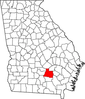 Map of Georgia highlighting Coffee County | |
| Unincorporated communities | ||
| ||