Amery Ice Shelf
The Amery Ice Shelf (69°45′S 71°0′E) is a broad ice shelf in Antarctica at the head of Prydz Bay between the Lars Christensen Coast and Ingrid Christensen Coast. It is part of Mac. Robertson Land. The name "Cape Amery" was applied to a coastal angle mapped on February 11, 1931, by the British Australian New Zealand Antarctic Research Expedition (BANZARE) under Douglas Mawson. He named it for William Bankes Amery, a civil servant who represented the United Kingdom government in Australia (1925–28). The Advisory Committee on Antarctic Names interpreted this feature to be a portion of an ice shelf and, in 1947, applied the name Amery to the whole shelf.
| Amery Ice Shelf | |
|---|---|
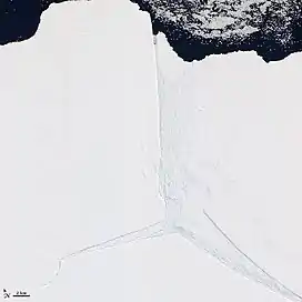
 Satellite image from early 2012 of a portion of the Amery Ice Shelf, where three giant rifts met. The "loose tooth" is to the right. The area to the left broke off the shelf in 2019 to form iceberg D-28. | |
 Location of Amery Ice Shelf in Antarctica | |
| Location | Mac. Robertson Land |
| Coordinates | 69°45′S 71°00′E |
In 2001 two holes were drilled through the ice shelf by scientists from the Australian Antarctic Division and specially designed seabed sampling and photographic equipment was lowered to the underlying seabed. By studying the fossil composition of sediment samples recovered, scientists have inferred that a major retreat of the Amery Ice Shelf to at least 80 km landward of its present location may have occurred during the mid-Holocene climatic optimum (about 5,700 years ago).[1]
In December 2006, it was reported by the Australian Broadcasting Corporation that Australian scientists were heading to the Amery Ice Shelf to investigate enormous cracks that had been forming for over a decade at a rate of three to five metres a day. Scientists wanted to discover what was causing the cracks, as there has not been similar activity since the 1960s. However, the head of research stated that it is too early to attribute the cause to global warming as there is the possibility of a natural 50-60 year cycle being responsible.[2]
Lambert Glacier flows from Lambert Graben into the Amery Ice Shelf on the southwest side of Prydz Bay.
The Amery Basin (68°15′S 74°30′E) is an undersea basin north of the Amery Ice Shelf.
The Chinese Antarctic Zhongshan Station and Russian Progress Station are located near this ice shelf.
The Amery Ice Shelf is the third largest ice shelf in Antarctica, after the Ross Ice Shelf and the Filchner-Ronne Ice Shelf.
Calving

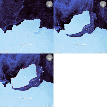
In September 2019, a large iceberg known as D-28 calved from the ice shelf. It was 1,636 square kilometres (632 sq mi)[3] in size (twice the size of New York City) and with an estimated weight of 315 billion tonnes.[4] As of October 2019, it continues to be monitored due to the threat it could pose to shipping channels. An adjacent ice formation, nicknamed the "loose tooth", was originally predicted to calve from the ice sheet between 2010 and 2015.[5]
As of February 2020, D-28 is currently lodged against the edge of the shelf, and slowly drifting northwards.
References
- Hemer, M.A., Harris, P.T., 2003. Sediment core from beneath the Amery Ice Shelf, East Antarctica, suggests mid-Holocene ice-shelf retreat. Geology 31, 127-130
- "Australians to study giant Antarctic ice cracks at ABC News Online (Friday, December 8, 2006. 6:29pm)". Archived from the original on 2007-01-08. Retrieved 2006-12-08.
- Cox, Lisa (1 September 2019). "Giant iceberg breaks off east Antarctica". TheGuardian.com. The Guardian. Retrieved 1 September 2019.
- "315 billion-tonne iceberg breaks off Antarctica". BBC News. 25 September 2019. Retrieved 3 October 2019.
- Amos, Jonathan (2019-09-30). "315 billion-tonne iceberg breaks off Antarctica". BBC. Retrieved 2019-09-30.
 This article incorporates public domain material from the United States Geological Survey document: "Amery Ice Shelf". (content from the Geographic Names Information System)
External links