Amur-Nyzhnodniprovskyi District
Amur-Nyzhnodniprovskyi District (Ukrainian: Амур-Нижньодніпровський район; sometimes abbreviated as "AND") is an urban district of the city of Dnipro, in southern Ukraine.[3][4] It is located on the city's north and on the left-bank of Dnieper River along with the city's Industrialnyi and Samarskyi districts. Its name is derived from a small settlement of Amur and the Nyzhnodniprovsk railway station. The first village located on what is now the Amur-Nyzhnodniprovskyi District was founded in the late 16th century, making the area one of the oldest inhabited parts of Dnipro.[1]
Amur-Nyzhnodniprovskyi District
Амур-Нижньодніпровський район | |
|---|---|
 Coat of arms | |
| Coordinates: 48°31′16″N 34°58′42″E | |
| Country | |
| Municipality | Dnipro Municipality |
| Established | 1918[1] |
| Area | |
| • Total | 71.626 km2 (27.655 sq mi) |
| Population | |
| • Total | 160,123 |
| • Density | 2,200/km2 (5,800/sq mi) |
| Time zone | UTC+2 (EET) |
| • Summer (DST) | UTC+3 (EEST) |
| Postal code | 70403 |
| Area code | +380 562 |
| KOATUU | 1210136300[2] |
| Website | andrada |
 |
History
According to historical findings on the current territory of the Amur-Nyzhnodniprovskyi District there was a village called Kamyanka that was founded in 1596.[1] Kamyanka is considered to be one of the oldest settlements in Left-bank Ukraine.[1] In 1757 the village Berezanivka was founded by the Zaporozhian Cossack Berezan.[1] The territory also contained the settlement of Manuylivka (the Ukrainian SSR changed the name to Vorontsovka in 1922) which was named after the Cossack settler Manuil.[1] Until 1786 all three villages belonged to belonged to the Samara province (palanka) of Zaporizhian Sich.[1] After the liquidation of Zaporizhian Sich by the Russian government of Catherine the Great in 1775, the region was admitted into the newly formed Novomoskovsk county of Yekaterinoslav Governorate.[1] The territory on the left bank of Dnieper across Yekaterinoslav at interfluvial region between Dnieper and Samara was known locally as Zadniprovia (Trans-Dnieper region).
The village of Amur emerged in 1875 and contained various factories.[1] To the east of Amur there was a village Baraf which was merged with Amur to form an industrial small city named Amur-Nyzhnodniprovskyi (Nyzhnodniprovskyi meaning "Lower Dnieper").[1] After a railway was laid in the area in 1895/1897 the area became heavy industrial.[1] In September 1917 all settlements of Zadniprovia were organized into a district of Zadniprovskyi Raion.[1] On 25 January 1918 the district was renamed into Amur-Nyzhnodniprovsk.[1]
In World War II the area saw heavy fighting during the June 1941 phase of Operation Barbarossa.[1]
In 1969 the district was split in half and at its eastern and northern portions was created the Industrialnyi District.[1] From the late 1970s until the mid 1980s the district was greatly expanded.[1]
Neighborhoods
- Amur
- Nyzhnodniprovsk
- Manuilivka
- Sakhalin
- Sultanivka
- Sonyachny
- Kalynovsky
- Borzhom
- Kamianka
- Lomivka
- Livoberezhny
- Berezanivka
Gallery
.jpg.webp) Panorama view of Amur-Nyzhnodniprovskyi District
Panorama view of Amur-Nyzhnodniprovskyi District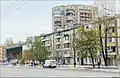 Amur-Nyzhnodniprovskyi District's Slobozhans'kyi Avenue
 Amur-Nyzhnodniprovskyi District's Slobozhans'kyi Avenue
 Soviet military cemetery
References
- "Amur-Nyzhnodniprovskyi Raion". Official Internet-portal (in Ukrainian). Dnipro City Council. Retrieved 17 August 2020.
- "Amur-Nyzhnodniprovskyi District Council". Informational portal of the self-government in Ukraine (in Ukrainian). Rada.info. Retrieved 5 February 2015.
- "Amur-Nyzhnodniprovskyi Raion, Dnipropetrovsk Oblast, City of Dnipropetrovsk". Regions of Ukraine and their Structure (in Ukrainian). Verkhovna Rada of Ukraine. Archived from the original on 4 March 2016. Retrieved 2 February 2015.
- (in Ukrainian) The Dubynskys' group played 49 million to patch holes after repairing heating networks, Ukrayinska Pravda (31 January 2020)
External links
| Wikimedia Commons has media related to Amur-Nyzhn'odniprovskyi District. |
| Districts | |||||
|---|---|---|---|---|---|
| Urban-type settlements | |||||
| Neighborhoods |
| ||||
| |||||