Angels Landing
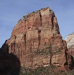
Angels Landing, known previously as the Temple of Aeolus, is a 1,488-foot (454 m) tall rock formation[2] in Zion National Park in southwestern Utah, United States. A trail cut into solid rock in 1926 leads to the top of Angels Landing and provides views of Zion Canyon.
| Angels Landing | |
|---|---|
 Angels Landing | |
| Highest point | |
| Elevation | 5,790 ft (1,760 m) |
| Prominence | 430 ft (130 m) [1] |
| Parent peak | Cathedral Mountain (6,930 ft)[1] |
| Isolation | 0.3 mi (0.48 km) [1] |
| Coordinates | 37°16′10″N 112°56′53″W |
| Geography | |
 Angels Landing (the United States) | |
| Topo map | USGS Temple of Sinawava |
| Geology | |
| Age of rock | Jurassic |
| Mountain type | Monolith |
| Type of rock | Navajo Sandstone |
Trail
In July 2018, the trail was closed following damage due to a severe storm. It was re-opened in September 2018. A chain was installed for balance. Since 2004, ten people have died from falling while hiking the trail.[3]
The trail to Angels Landing is 2.5 miles (4.0 km) long with an approximate 1,500 feet (460 m) elevation gain. The hike is rated as a class 3 difficulty based on the Yosemite Decimal System.[4] It begins at the Grotto drop off point on the park's shuttle system, which operates from early spring through late fall.[5] It roughly follows the path of the Virgin River for some time along the West Rim Trail, slowly gaining elevation in sandy terrain. Most of the trail is uphill on the way up to Angels Landing. As the trail gets steeper and leaves behind the river, it becomes paved. After a series of steep switchbacks, the trail goes through the area between Angels Landing and the Zion Canyon that is a gradual ascent. Walter's Wiggles, a series of 21 steep switchbacks, are the last hurdle before Scout Lookout. The wiggles are named after Walter Ruesch, who was the first superintendent for Zion National Park and constructed the switchbacks in 1926.[6]
Scout Lookout is generally the turnaround point for those who are unwilling to make the final summit push to the top of Angels Landing. The last half-mile of the trail is strenuous and lined with numerous sharp drop offs and narrow paths. Chains to grip are provided for portions of the last half-mile to the top at 5,790 feet (1,760 m).[7]
The half-mile section up the spine, the Angels Landing Trail-West Rim Trail, was listed in the National Register of Historic Places in 1987.[8]
The National Park Service website officially recognizes eight fatalities where suspicious activity was not involved along Angels Landing.[9]
Climate
Spring and fall are the most favorable seasons to visit Angels Landing. According to the Köppen climate classification system, it is located in a Cold semi-arid climate zone, which is defined by the coldest month having an average mean temperature below 32 °F (0 °C), and at least 50% of the total annual precipitation being received during the spring and summer. This desert climate receives less than 10 inches (250 millimeters) of annual rainfall, and snowfall is generally light during the winter.[10]
Gallery
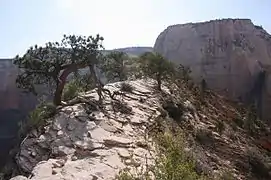
Summit of Angels Landing 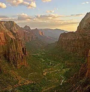
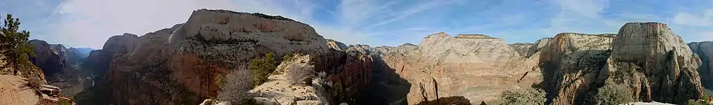
Zion Canyon as seen from the summit of Angels Landing 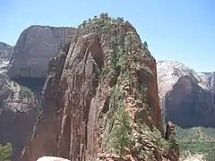 Looking toward the top of Angel's Landing
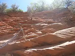 Angel's Landing trail including chain cables
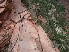 Zion Canyon viewed from Angel's Landing, showing the immense vertical relief
See also
References
- "Angels Landing, Utah". Peakbagger.com.
- Zion National Park eHike
- "Frequently Asked Questions about Zion's Hiking Trails". National Park Service. August 9, 2018. Retrieved July 3, 2019.
- "Angel's Landing: Climbing, Hiking, and Mountaineering". summitpost.org. SummitPost. Retrieved 2017-12-17.
- Lloyd, Tommy. "Angels Landing Hike - Not for the Faint of Heart". mountainranges.org. mountainranges. Archived from the original on 8 December 2015. Retrieved 4 December 2015.
- "Angel's Landing in Zion National Park". hikespeak.com. Hikespeak. Retrieved 2017-01-04.
- Annie, Hartman (12 July 2018). "Angels Landing Is One of the Most Dangerous Hikes in the US". Curiosity: Amazing Places. curiosity.com. Retrieved 23 August 2018.
- Jurale, Jim; Witherall, Nancy (1984). "National Register of Historic Places Inventory - Nomination Form: Multiple Resources for Zion National Park". National Park Service. Retrieved 2009-09-03.
- "Frequently Asked Questions about Zion's Hiking Trails". Retrieved 10 July 2011.
- "Zion National Park, Utah, USA - Monthly weather forecast and Climate data". Weather Atlas. Archived from the original on August 31, 2020. Retrieved 31 August 2020.
External links
| Wikimedia Commons has media related to Angels Landing (Zion National Park). |