Angern an der March
Angern an der March (Slovak: Congr) is a market town in the district of Gänserndorf in the Austrian state of Lower Austria. The municipality consists of the Katastralgemeinden Angern, Grub, Mannersdorf, Ollersdorf and Stillfried.
Angern an der March | |
|---|---|
 Coat of arms | |
 Angern an der March Location within Austria | |
| Coordinates: 48°23′N 16°50′E | |
| Country | Austria |
| State | Lower Austria |
| District | Gänserndorf |
| Government | |
| • Mayor | Robert Meißl (SPÖ) |
| Area | |
| • Total | 38.17 km2 (14.74 sq mi) |
| Elevation | 154 m (505 ft) |
| Population (2018-01-01)[2] | |
| • Total | 3,384 |
| • Density | 89/km2 (230/sq mi) |
| Time zone | UTC+1 (CET) |
| • Summer (DST) | UTC+2 (CEST) |
| Postal code | 2301 |
| Area code | 02215 |
| Website | www.angern.at |
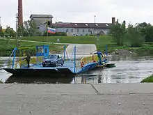
Angern is situated in the Weinviertel region, within the northern Marchfeld basin of the Morava (German: March) river, about 40 kilometers (25 mi) northeast of Vienna. The river forms the border with the village of Záhorská Ves in Slovakia, it is crossed by a small car ferry while plans for rebuilding a former bridge are currently under discussion.
The settlement of Anger in the Duchy of Austria was first mentioned in 1260 deed and already referred to as a market town in 1495, a title that it again received in 1970. The Baroque St Roch Chapel at Mannersdorf was built in 1635. Anger Castle was finally demolished in World War II.
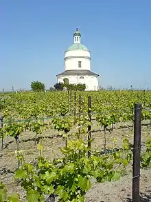
The area is the site of several vineyards.
Transportation
Angern has access to the Northern Railway (Nordbahn) line from Vienna to Brno. It also lies at the junction of the Bundesstraße B8 Angerner Straße highway from Vienna with the B49 Bernstein Straße, part of the ancient Amber route.
References
- "Dauersiedlungsraum der Gemeinden Politischen Bezirke und Bundesländer - Gebietsstand 1.1.2018". Statistics Austria. Retrieved 10 March 2019.
- "Einwohnerzahl 1.1.2018 nach Gemeinden mit Status, Gebietsstand 1.1.2018". Statistics Austria. Retrieved 9 March 2019.
| Wikimedia Commons has media related to Angern an der March. |
| Authority control |
|---|
