Angoville, Calvados
Angoville is a former commune in the Calvados department in the Normandy region of north-western France. On 1 January 2019, it was merged into the new commune of Cesny-les-Sources.[2]
Angoville | |
|---|---|
Part of Cesny-les-Sources | |
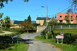 The road into Angoville | |
Location of Angoville 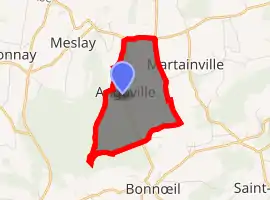
| |
 Angoville  Angoville | |
| Coordinates: 48°56′45″N 0°22′39″W | |
| Country | France |
| Region | Normandy |
| Department | Calvados |
| Arrondissement | Caen |
| Canton | Thury-Harcourt |
| Commune | Cesny-les-Sources |
| Area 1 | 3.72 km2 (1.44 sq mi) |
| Population (2017)[1] | 27 |
| • Density | 7.3/km2 (19/sq mi) |
| Time zone | UTC+01:00 (CET) |
| • Summer (DST) | UTC+02:00 (CEST) |
| Postal code | 14220 |
| Elevation | 173–248 m (568–814 ft) (avg. 220 m or 720 ft) |
| 1 French Land Register data, which excludes lakes, ponds, glaciers > 1 km2 (0.386 sq mi or 247 acres) and river estuaries. | |
The inhabitants of the commune are known as Angovillais or Angovillaises[3]
Geography
Angoville is located some 30 km south of Caen and 10 km east by south-east of Thury-Harcourt. The D6 road from Thury-Harcourt to Ussy forms the northern border of the commune. Access to the commune is by the D241 road from Tréprel in the south which passes through the length of the commune and the village and continues north to join the D6 on the border. The commune is mostly farmland with an area of forest in the south which is part of the large Bois de Saint-Claire.[4]
Neighbouring communes and villages[4] | |
|---|---|
History
Toponymy
Angoville is composed of the old French "ville" (from the Latin "Villae") meaning a rural area or village and a Scandinavian name Asgaut (or Asgautr),[5] gallicized to Asgot, Ansgot, Angot, and Ango - originally the Norman surname Ango[6] and Angot[7] which are widespread in Seine-Maritime.
Administration
List of Successive Mayors of Angoville[8]
| From | To | Name | Party | Position |
|---|---|---|---|---|
| ? | ? | Louis-Aimable Auvray[9] | Farmer | |
| ? | ? | M. Pourdais (Father) | ||
| ? | 2001 | Guy Bourdais | ||
| 2001 | 2014 | Daniel Simon | SE | Farmer |
| 2014 | 2019 | Éric Sohier | SE | Editor |
(Not all data is known)
Demography
In 2017, the commune had 27 inhabitants.
|
| |||||||||||||||||||||||||||||||||||||||||||||||||||||||||||||||||||||||||||||||||||||||||||||||||||||||||||||||
| Source: EHESS[10] and INSEE[11] | ||||||||||||||||||||||||||||||||||||||||||||||||||||||||||||||||||||||||||||||||||||||||||||||||||||||||||||||||
Economy
The main activities are dairy farming and cropping.
Culture and heritage
Civil heritage
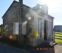
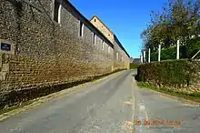
The commune has a number of buildings and structures that are registered as historical monuments:
Religious heritage
The commune has several religious buildings and structures that are registered as historical monuments:
See also
External links
- Angoville, Calvados on Lion1906
- Angoville on Géoportail, National Geographic Institute (IGN) website (in French)
- Angoville on the 1750 Cassini Map
References
- Téléchargement du fichier d'ensemble des populations légales en 2017, INSEE
- Arrêté préfectoral 24 September 2018, p. 124 (in French)
- Inhabitants of Calvados (in French)
- Google Maps
- National Scientific Research Centre (France), Annals of Normandy, Volume 52, Nos. 1 to 5, Regional Ethnographic Laboratory, 2002 (in French)
- Ango in Géopatronyme website (in French)
- Angot in Géopatronyme website (in French)
- List of Mayors of France (in French)
- Annual of the department of la Manche, 12th edition, 1840, p 223
- Des villages de Cassini aux communes d'aujourd'hui: Commune data sheet Angoville, EHESS. (in French)
- Populations légales 2012, INSEE
- Ministry of Culture, Mérimée IA00000570 Houses and Farms (in French)
- Ministry of Culture, Mérimée IA00000569 Farmhouse (in French)
- Ministry of Culture, Mérimée IA00000568 Saint Anne Fountain (in French)
- Ministry of Culture, Mérimée IA00000564 Town Hall (in French)
- Ministry of Culture, Mérimée IA00000568 Motte de Rouvrou Fortified Site (in French)
- Ministry of Culture, Mérimée IA00000567 Tomb of the Rabâche family (in French)
- Ministry of Culture, Mérimée IA00000566 Tomb of Jean-François Rabâche (in French)
- Ministry of Culture, Mérimée IA00000565 Tomb of Priest François Bouquet (in French)
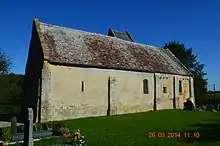
- Ministry of Culture, Mérimée IA00000562 Parish Church of Saint-Anne (in French)
| Wikimedia Commons has media related to Angoville. |
| Authority control |
|---|