Anta Province
Anta Province is one of thirteen provinces in the Cusco Region in the southern highlands of Peru.
Anta | |
|---|---|
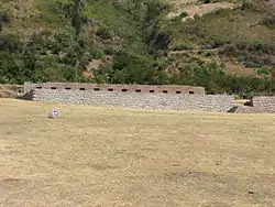 The archaeological site of Tarawasi in the Anta Province | |
 Flag | |
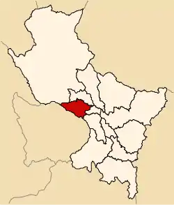 Location of Anta in the Cusco Region | |
| Country | Peru |
| Region | Cusco |
| Capital | Anta |
| Government | |
| • Mayor | Wilbert Gabrwilbert Gabriel Rozas Beltran (2007) |
| Area | |
| • Total | 1,876.12 km2 (724.37 sq mi) |
| Population (2005 census) | |
| • Total | 57,905 |
| • Density | 31/km2 (80/sq mi) |
| UBIGEO | 0803 |
| Website | www |
Geography
The Willkapampa mountain range traverses the province. The highest peak of the province is Sallqantay at 6,271 metres (20,574 ft). Other mountains are listed below:[1]
- Amparay
- Anawillka Q'asa
- Aqu Q'asa
- Aya Samachina
- Hatun Q'asa
- Hatun Urqu
- Imillay
- Llama Wasi
- Minasniyuq
- Muyuq
- Pitu Phaqcha
- Puka Q'asa
- Qiwllawina
- Sinqa
- Sullu Qaqa
- Suray
- Tiklla
- Tukarway
- Uqhupampa
- Yana Qaqa
- Yanaqucha
- Yawar Quchayuq
Political division
The province is divided into nine districts (Spanish: distritos, singular: distrito), each of which is headed by a mayor (alcalde). The districts, with their capitals in parenthesis, are:
- Ancahuasi (Ancahuasi)
- Anta (Anta)
- Cachimayo (Cachimayo)
- Chinchaypujio (Chinchaypujio)
- Huarocondo (Huarocondo)
- Limatambo (Limatambo)
- Mollepata (Mollepata)
- Pucyura (Pucyura)
- Zurite (Zurite)
Ethnic groups
The people in the province are mainly indigenous citizens of Quechua descent. Quechua is the language which the majority of the population (70.28%) learnt to speak in childhood, 29.35% of the residents started speaking in Spanish.[2]
Sources
- escale.minedu.gob.pe - UGEL map of the Anta Province (Cusco Region)
- inei.gob.pe Archived January 27, 2013, at the Wayback Machine INEI, Peru, Censos Nacionales 2007

| |
|---|---|
This article is issued from Wikipedia. The text is licensed under Creative Commons - Attribution - Sharealike. Additional terms may apply for the media files.