Apodotia
Apodotia (Greek: Αποδοτία) is a former municipality in Aetolia-Acarnania, West Greece, Greece. Since the 2011 local government reform it is part of the municipality Nafpaktia, of which it is a municipal unit.[2] The municipal unit has an area of 257.635 km2.[3] The seat of the municipality, established in 1996, was the village Ano Chora.[4] An earlier municipality Apodotia existed between 1835 and 1912.[4]
Apodotia
Αποδοτία | |
|---|---|
 Apodotia Location within the regional unit 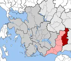 | |
| Coordinates: 38°36′N 21°56′E | |
| Country | Greece |
| Administrative region | West Greece |
| Regional unit | Aetolia-Acarnania |
| Municipality | Nafpaktia |
| • Municipal unit | 257.6 km2 (99.5 sq mi) |
| Population (2011)[1] | |
| • Municipal unit | 2,636 |
| • Municipal unit density | 10/km2 (27/sq mi) |
| Time zone | UTC+2 (EET) |
| • Summer (DST) | UTC+3 (EEST) |
| Postal code | 300 23 |
| Area code(s) | 26340 |
Subdivisions
The municipal unit Apodotia is subdivided into the following communities (constituent villages in brackets):
- Ano Chora
- Ampelakiotissa
- Anavryti
- Aspria
- Grammeni Oxya
- Grigori
- Elatovrysi
- Elatou
- Kalloni
- Katafygio (Katafygio, Golemi)
- Kato Chora
- Kentriki (Kentriki, Sellos)
- Kokkinochori (Kokkinochori, Sotiro, Chrisovo)
- Kryoneria
- Kydonea
- Lefka
- Limnitsa
- Mandrini
- Podos
- Terpsithea
References
- "Απογραφή Πληθυσμού - Κατοικιών 2011. ΜΟΝΙΜΟΣ Πληθυσμός" (in Greek). Hellenic Statistical Authority.
- Kallikratis law Greece Ministry of Interior (in Greek)
- "Population & housing census 2001 (incl. area and average elevation)" (PDF) (in Greek). National Statistical Service of Greece. Archived from the original (PDF) on 2015-09-21.
- "EETAA local government changes". Retrieved 29 June 2020.
This article is issued from Wikipedia. The text is licensed under Creative Commons - Attribution - Sharealike. Additional terms may apply for the media files.
