Apolima
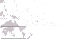
Apolima is the smallest of the four inhabited islands of Samoa. It lies in the Apolima Strait, between the country's two largest islands: Upolu to the east, and Savai'i to the west.
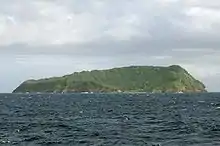 Apolima seen from the Upolu-Savai'i ferry | |
 | |
| Geography | |
|---|---|
| Location | Pacific Ocean |
| Coordinates | 13.824°S 172.151°W |
| Administration | |
Samoa | |
| Demographics | |
| Population | 75 (2006) |

The island has one village settlement, Apolima Tai, with a population of 75 (2006 Census).[1] The small settlement is situated in the interior's flat plateau, on the northern side.
Apolima is thr rim of an extinct volcanic crater with a maximum height of 165 m. Its area is slightly less than one square kilometer. The only access to the island is by boat.
The tiny island lies 2.4 kilometres (1.5 mi) northwest off the westernmost edge of Upolu Island’s fringing reef and 7 km (4 mi) southwest of the island of Savai'i. The island's shape is like an upturned bowl surrounded by steep cliffs. There is a broad opening to the sea on the northern side, which is the main entry point. Entry is only by boat.
There are two neighbouring islands in the strait, Manono Island, which has a small population, and the smaller, uninhabited islet of Nu'ulopa.
Apolima island is part of the political district of Aiga-i-le-Tai.[2]
Gallery
- Historical images of Apolima by Thomas Andrew (1855 - 1939)
 Entrance to Apolima, left side
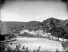 Apolima village, circa 1890 - 1910
 Interior of the island, 1904
See also
References
- "Population and Housing Census Report 2006" (PDF). Samoa Bureau of Statistics. July 2008. Archived from the original (PDF) on 21 July 2011. Retrieved 16 December 2009.
- "Samoa Territorial Constituencies Act 1963". Pacific Islands Legal Information Institute. Archived from the original on 5 June 2011. Retrieved 16 December 2009.
Traditional centre: Manono Island | ||
| Villages | 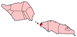 | |
| Islands |
| |
| Transportation |
| |
| Archaeology in Samoa |
| |
| Environment | ||
| Electoral constituency: Faipule District |
| |