Argens
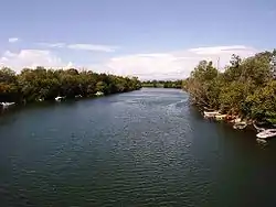
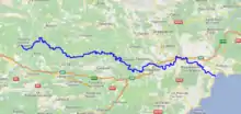
The Argens (French pronunciation: [aʁʒɛ̃(s)]; Occitan: Argens) is a 116 km long river of the French Riviera.[1] Its 2,734 km2 (1,056 sq mi) drainage basin is fully included in the Var department.[2]
| Argens | |
|---|---|
 | |
 | |
| Native name | L'Argens (m) (French) |
| Location | |
| Country | France |
| Physical characteristics | |
| Mouth | |
• location | Mediterranean Sea |
• coordinates | 43°24′36″N 6°44′14″E |
| Length | 116 km (72 mi) |
| Basin size | 2,734 km2 (1,056 sq mi) |
The river goes through Vidauban, Le Muy, Roquebrune-sur-Argens, Fréjus, then it flows into the Mediterranean Sea, near Fréjus.
Name
The river is attested as ad flumen Argenteum in the 1st century BC, Argenteus in the 1st century AD, and A̓rgentíou (Ἀργεντίου) in the 2nd century. It derives from the Latin or Celtic word for 'silver'.[3]
Rivers flowing into Argens
- Blavet
- Endre
- Bresque
- Caramy
- Issole
- Cassole
- Ribeirotte
- Florieye
- Aille
- Nartuby
- Reyran
References
- Sandre. "Fiche cours d'eau - L'Argens (Y5--0200)".
- Bassin versant : Argens (L'), Observatoire Régional Eau et Milieux Aquatiques en PACA
- Falileyev 2010, s.v. Argenteus.
- Bibliography
- Falileyev, Alexander (2010). Dictionary of Continental Celtic Place-names: A Celtic Companion to the Barrington Atlas of the Greek and Roman World. CMCS. ISBN 978-0955718236.
This article is issued from Wikipedia. The text is licensed under Creative Commons - Attribution - Sharealike. Additional terms may apply for the media files.
