Aripuanã River
Aripuanã River (Portuguese: Rio Aripuanã) is a river in the Mato Grosso and Amazonas states in north-western Brazil. It is a tributary of the Madeira River in the Amazon Basin. The town of Novo Aripuanã is located on its banks where it merges into the Madeira River. The town of Aripuanã is also on its banks, but on the upper (southern) section of the river.
| Aripuanã River | |
|---|---|
 The confluence of the Madeira River (brown) and Aripuanã River (dark) near the town of Novo Aripuanã. Despite its color on this photo, Aripuanã is clearwater rather than a blackwater. | |
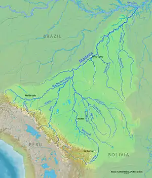 Madeira Basin with Aripuanã River above right. At the junction the right branch (opposite Roosevelt River) is a continuation of the Aripuanã. The uppermost (southern) section of the Aripuanã is not shown | |
| Location | |
| Country | Brazil |
| Physical characteristics | |
| Source | |
| • location | Mato Grosso, Brazil |
| Mouth | Madeira River |
• location | Novo Aripuanã, Amazonas, Brazil |
• coordinates | 5°7′7″S 60°22′55″W |
| Length | 870 km (540 mi)[1] |
| Discharge | |
| • average | 3,400 m3/s (120,000 cu ft/s) |
| Basin features | |
| Tributaries | |
| • left | Juma River, Roosevelt River, Guaribe River, Branco River |
| • right | Arauá River |
The Aripuanã is a clearwater river.[2][3]
Course
In Mato Grosso to the south of the border with Amazonas the river defines the western boundary of the 227,817 hectares (562,950 acres) Igarapés do Juruena State Park, created in 2002.[4] To the north of the Amazonas border it flows through the 224,291 hectares (554,240 acres) Aripuanã Sustainable Development Reserve, created in 2005.[5]
Further north in Amazonas the Trans-Amazonian Highway (BR-230) crosses the Aripuanã. North of the highway the river flows through the 751,302 hectares (1,856,510 acres) Aripuanã National Forest, a sustainable development unit created in 2016 in the last week before the provisional removal of president Dilma Rousseff. It then flows through the Juma Sustainable Development Reserve before meeting the Madeira.[6]
There are four dams on the river (Dardanelos Dam, Faxinal I and Faxinal II at Aripuanã town, and Juína Dam west of Juína) and a fifth is planned (Prainha Dam on the middle Aripuanã River). These have impacted the environment and caused conflicts with indigenous people.[7][8]
References
- Ziesler, R.; Ardizzone, G.D. (1979). "Amazon River System". The Inland waters of Latin America. Food and Agriculture Organization of the United Nations. ISBN 92-5-000780-9. Archived from the original on 21 October 2013.
- Goulding, M. (1981). Man and Fisheries on an Amazon Frontier. p. 15. ISBN 978-90-481-8520-7.
- Blum, M.D.; S.B. Marriott; S.F. Leclair, eds. (2005). Fluvial Sedimentology VII (Special Publication 35 of the IAS) (2nd ed.). p. 29. ISBN 978-90-481-8520-7.
- PES Igarapés do Juruena – ISA, Informações gerais (mapa).
- RDS Aripuanã – ISA, Informações gerais (mapa).
- FLONA do Aripuanã – ISA.
- Hurwitz, Z. (29 July 2010). Another Indigenous Tragedy Highlights the Inviability of Amazonian Dams. International Rivers. Retrieved 27 May 2014
- Ecolnews:Usina de Dardanelos, crime ambiental premeditado e consolidado. Archived 2014-05-27 at the Wayback Machine Retrieved 27 May 2014
Sources
- FLONA do Aripuanã (in Portuguese), ISA: Instituto Socioambiental, retrieved 2016-06-15
- PES Igarapés do Juruena (in Portuguese), ISA: Instituto Socioambiental, retrieved 2016-07-11
- RDS Aripuanã (in Portuguese), ISA: Instituto Socioambiental, retrieved 2016-07-12