Mato Grosso
Mato Grosso (Portuguese pronunciation: [ˈmatu ˈɡɾosu] – lit. "Thick Bush") is one of the states of Brazil, the third largest by area, located in the western part of the country.[3] The state has 1.66% of the Brazilian population and is responsible for 1.9% of the Brazilian GDP.
State of Mato Grosso
Estado de Mato Grosso | |
|---|---|
 Flag  Coat of arms | |
| Motto(s): Virtute Plusquam Auro ("By virtue more than by gold") | |
| Anthem: Hino de Mato Grosso | |
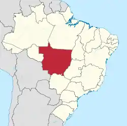 Location of Mato Grosso (in red) in Brazil | |
| Coordinates: 15°34′S 56°04′W | |
| Country | |
| Capital and largest city | Cuiabá |
| Government | |
| • Governor | Mauro Mendes (DEM) |
| • Vice Governor | Otaviano Pivetta (PDT) |
| • Senators | Carlos Fávaro (PSD) Jayme Campos (DEM) Wellington Fagundes (PL) |
| Area | |
| • Total | 903,357 km2 (348,788 sq mi) |
| Area rank | 3rd |
| Population (2010)[1] | |
| • Total | 3,035,122 |
| • Estimate (2019) | 3,484,466 |
| • Rank | 17th |
| • Density | 3.4/km2 (8.7/sq mi) |
| • Density rank | 25th |
| Demonym(s) | Mato-grossense |
| GDP | |
| • Year | 2014 estimate |
| • Total | R$ 101.235 billion (14th) |
| • Per capita | R$ 31,396,81 (8th) |
| HDI | |
| • Year | 2017 |
| • Category | 0.774[2] – high (8th) |
| Time zone | UTC-4 (BRT-1) |
| • Summer (DST) | UTC-3 (BRT-1) |
| Postal Code | 78000-000 to 78890-000 |
| ISO 3166 code | BR-MT |
| Website | mt.gov.br |
Neighboring states (from west clockwise) are: Rondônia, Amazonas, Pará, Tocantins, Goiás and Mato Grosso do Sul. The nation of Bolivia is located to the southwest. A state with a flat landscape that alternates between vast chapadas and plain areas, Mato Grosso contains three main ecosystems: the Cerrado, the Pantanal and the Amazon rainforest. Open pasture vegetation covers 40% of the state.
The Chapada dos Guimarães National Park, with caves, grottoes, tracks, and waterfalls, is one of its tourist attractions. In the north is the biodiverse Amazonian forest, which originally covered half of the state. Much of this has been disrupted and cleared for logging, agricultural purposes and pastures. The Xingu Indigenous Park and the Araguaia River are in Mato Grosso. Further south, the Pantanal, the world's largest wetland, is the habitat for nearly one thousand species of animals and many aquatic birds.
Geography
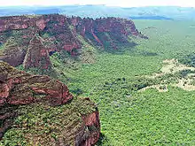
The terrain of Mato Grosso is varied and includes cliffs, canyons, and waterfalls. It is home to the Chapada dos Guimarães National Park, a unique environment of sandstone mountains that have eroded into amazingly varied terrain.
The biologically rich Pantanal, one of the world's largest wetland/prairie ecosystems, is also located within this state. Much environmental degradation has occurred to the Pantanal since the late 20th century because of development, and efforts to contain or slow it have had limited success. The Pantanal has a habitat similar to that of the Everglades in Florida in the United States, although the Pantanal is on a much larger scale.
History
- See also: History of Mato Grosso
The Bororo Indians live in the Mato Grosso area. As late as 1880, soldiers patrolled lands on the outskirts of Cuiabá, Mato Grosso's capital and largest city, to protect settlers from Bororo raids.
By the end of the 19th century, although severely reduced by disease and by warfare with explorers, slave traders, prospectors, settlers, and other indigenous groups, as many as five to ten thousand Bororo continued to occupy central and eastern Mato Grosso, as well as western Goiás.[4] The southwestern part of this state was ceded by Brazil to Bolivia in exchange for the then-Bolivian territory of Acre, according to the Treaty of Petrópolis in 1903.
This historically remote area attracted expeditions of exploration in the early 20th century that sought to find lost civilizations. A notable example was British Captain Percy Fawcett's expedition to find the Lost City of Z which he believed existed in the jungles of Brazil. Certain proponents of the Hollow Earth hypothesis speculated that the region had sites of access to the interior of the earth and its settlements.
In 1977, the state was split into two halves, and the neighboring state of Mato Grosso do Sul was created from the other part of its territory.
Demographics
Mato Grosso had a high rate of population growth in the 20th century due to timber, ranching and agricultural development. The state as a whole has one of the lowest population densities of any Brazilian state. According to the Brazilian Institute of Geography and Statistics (IBGE), 3,441,998 people resided in the state as of 2018. The population density was 3.8 inhabitants/km2.
- Urbanization: 76.6% (2006)
- Population growth: 2.4% (1991–2000)
- Houses: 836,000 (2006)[5]
Ethnically, the state includes a relatively high proportion of caboclos (persons of mixed European and Indian ancestry), as do other areas of interior Brazil. The last PNAD (National Research for Sample of Domiciles) census revealed the following numbers: 1,532,000 Brown (Mixed) people (50.92%); 1,179,000 White people (39.16%); 239,000 Black people (7.93%); 41,000 Amerindian people (1.37%); and 14,000 Asian people (0.45%).[6]
Largest cities
Economy
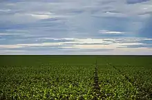
Agriculture is the largest component of the state's GDP at 40.8%, followed by the service sector at 40.2%. The industrial sector represents 19% of the GDP (2004). Mato Grosso's major exports include soybeans (83%), wood (5.6%), meats (4.8%), and cotton (3.3%) (2002).
The state's share of the Brazilian economy is 1.8% (2014).
In 2020, Mato Grosso was the leader in the national grain production, with 28.0%.[8] It's the largest producer of soy in Brazil, with 26.9% of the total produced in 2020 (33.0 million tons); the largest producer of maize in the country;[9] the largest producer of cotton in Brazil, with around 65% of national production (1.8 out of the 2.8 million tons harvested in the country).;[10][11] the 6th largest producer of sugarcane in the country, 16 million tons harvested in the 2019/20 harvest.;[12][8] and the 3rd largest producer of beans, with 10.5% of Brazilian production.[8] In sunflower, the state was the largest national producer in 2019, with 60 thousand tons.[13] In cassava production, Brazil produced a total of 17.6 million tons in 2018. Mato Grosso produced 287 thousand tons at this year.[14]
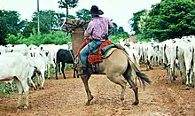
In 2019, the cattle herd from Mato Grosso reached the mark of thirty million cattle, the largest cattle herd in the country, representing almost 14% of national production alone. In 2018, Mato Grosso was the fifth largest pork producer in the country, with a herd of around 2.5 million animals.[15][16][17][18]
In 2017, Mato Grosso had 1.15% of the national mineral participation (5th place in the country). Mato Grosso had production of gold (8.3 tons at a value of R$1 billion) and tin (536 tons at a value of R$16 million).[19] In addition, in gemstones, the state is the 2nd largest national producer of diamond, having extracted 49 thousand carats in the year 2017. The city of Juína is the main one in this activity in the state. The state also has a small production of sapphire and jasper.[20][21]
Mato Grosso had an industrial GDP of R$17.0 billion in 2017, equivalent to 1.4% of the national industry. It employs 141,121 workers in the industry. The main industrial sectors are: Construction (32.0%), Food (27.9%), Industrial Services of Public Utility, such as Electricity and Water (18.6%), Beverages (4.5%) and Oil Products Oil and Biofuels (3.9%). These 5 sectors concentrate 86.9% of the state's industry.[22]
Statistics
- Vehicles: 1,614,797 (January 2015)
- Mobile phones: 4,500,000 (January 2015)
- Telephones: 527,000 (April 2007)
- Cities: 141 (2007)[23]
Education
Portuguese is the official national language and the primary language taught in schools. English and Spanish are also taught as part of the official high school curriculum.
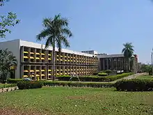
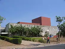
More than 58 universities are located in the state of Mato Grosso.[24]
Cuiabá is home to the following universities:
- Federal University of Mato Grosso (UFMT);
- Mato Grosso State University (Unemat);
- Universidade de Cuiabá (Unic).
Culture
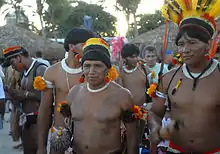
The local culture is very rich due to the influences of and encounters with various cultures, such as indigenous peoples, colonial Spanish and other European settlers, Africans enslaved and transported there in the Atlantic slave trade, originally by the Portuguese, and other Europeans; and immigrants and settlers since the late 19th century. Two long periods of isolation also contributed to its development along different lines than the coastal areas of Brazil. Recent immigration has brought many urban influences to the state. Cuiabá has a rich cuisine influenced by natives. They have maintained traditional dances, craftwork and music.
Dance and music were traditionally connected to the worship of Catholic saints and their festivals, Saint Benedict (the city's patron saint) being one of the favorites.
Carnival
The four-day period before Lent leading up to Ash Wednesday, known as Carnival, is well celebrated. As with every state in Brazil, Mato Grosso celebrates this holiday in a typical fashion - including parades, music, and dance - with wide participation.
Flag
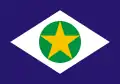
The state flag has similar colors to the flag of Brazil, with blue symbolizing the sky, green the vegetation, and white standing for peace. The star is yellow to symbolize the gold which attracted the first settlers. The flag was adopted by Decree No. 2 of January 31, 1890, just a few days after the adoption of the national flag. The Mato Grosso state flag was abolished by Law No. 1.046 of October 8, 1929, but reinstated by article 140 of the Constitution of the State of Mato Grosso on July 11, 1947.
Alta Floresta
Fishing in the Teles Pires, São Benedito and Azul rivers is productive practically all year long.
With more than 570 species of catalogued birds and new species being discovered every year, the region of Alta Floresta, Cristalino and the Azul River Basin receives constant visits from ornithologists and bird watchers.
Chapada dos Guimarães
The largest sandstone cavern in Brazil, Aroe Jari, extends nearly 1,550 metres (5,090 ft), and several prehistoric inscriptions can be found inside.
North Pantanal
The Pantanal's backbone is the Paraguay River, which cuts through the region from north to south. The Miranda, Aquidauna, Taquari and Cuiabá rivers flow into the Paraguay River. From October to April, the high waters reveal outsized lakes, bays, river branches and outlets.
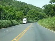
The Transpantaneira Highway connects the town of Poconé to Jofre Port, along the Cuiabá River bank. It is a dirt road with 126 wooden bridges, and extends for 149 kilometres (93 mi). On the way, it is possible to observe wild animals, especially alligators, capybaras and birds, among other wild animals.
SESC's Private Natural Heritage Reserve (RPPN) increases by one-third the total area of this preserved ecosystem in Mato Grosso.
Over 160 different species of birds have been observed in the Pantanal, and still many species in the area have not yet been identified.
Águas Quentes State Park
The 1,487 hectares (3,670 acres) Águas Quentes State Park, the first protected area in Mato Grosso, is known for the healing powers of its thermal waters.[25]
Lagoa Azul State Park
The Gruta da Lagoa Azul State Park (Portuguese: Parque Estadual Gruta da Lagoa Azul) is a state park in the municipality of Nobres, Mato Grosso, with an area of 12,513 hectares (30,920 acres).[26] Its primary attraction is a limestone cave with a pool of blue water and unusual cave formations. These have suffered from vandalism, causing the cave to be closed until measures to protect it could be implemented. The blue lagoon cave holds a pool of blue water formed from underground water of the Saloba River.[27] The main entrance is filled in part by the water. The hall contains columns over 5 metres (16 ft) in size and 1 metre (3 ft 3 in) in diameter. There may be archaeological remains in the cave. The park has several other limestone caves. It is covered with deciduous forests, and is home to howler monkeys, tapirs, jaguars and macaws.[28]
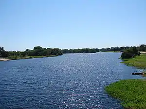
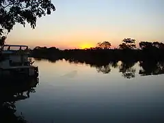 Paraguay River in Mato Grosso
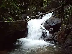 Salgadeira Waterfall
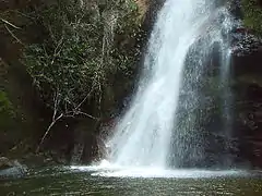 Andorinha Waterfall
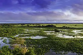 Pantanal in Mato Grosso
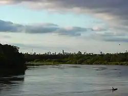
Infrastructure
International airport

The runway at Marechal Rondon International Airport was opened to traffic in 1956. In February 1975, Infraero took over the airport's administration and began various upgrades to meet the needs of the airport complex.
Marechal Rondon International Airport, located 10 kilometres (6.2 mi) from the city center, started receiving international flights in 1996. It now serves more than half a million passengers a year.
Sports
.jpg.webp)
Cuiabá was one of twelve cities chosen to host the games of the 2014 FIFA World Cup, which took place in Brazil.
See also
References
- "Projeção da população do Brasil e das Unidades da Federação" [Projected population of Brazil and the Federal States] (in Portuguese). Instituto Brasileiro de Geografia e Estatística. 1 March 2018. Archived (PDF) from the original on 18 September 2017. Retrieved 1 March 2018.
- "Radar IDHM: evolução do IDHM e de seus índices componentes no período de 2012 a 2017" (PDF) (in Portuguese). PNUD Brasil. Retrieved 18 April 2019.
- Note: also once spelled "Matto Grosso". The town of Matto Grosso was formerly called Villa Bella." Source: Exploration of the Valley of the Amazon, vol.2, by Lieut. USN. Lardner Gibbon 1853; chapter 11. p. 275
- "Myths of pacification: Brazilian frontier settlement and the subjugation of the Bororo Indians", Encyclopedia
- Source: PNAD.
- "Pesquisa Nacional por Amostra de Domicílios: Tabela 262 - População residente, por cor ou raça, situação e sexo" [National Household Sample Survey: Table 262 - Resident population, by color or race, situation and sex] (PDF) (in Portuguese). Mato Grosso, Brazil: IBGE. 2008. ISBN 85-240-3919-1. Retrieved 2010-01-18.
- "Estimativas da população residente nos municípios brasileiros com data de referência em 1º de julho de 2011" [Estimates of the Resident Population of Brazilian Municipalities as of July 1, 2011] (in Portuguese). Brazilian Institute of Geography and Statistics. 30 August 2011. Archived from the original (PDF) on 31 August 2011. Retrieved 31 August 2011.
- IBGE prevê safra recorde de grãos em 2020
- Quatro estados concentram quase 70% da produção de grãos do país
- Qualidade do algodão de MT é destaque em congresso nacional
- MT segue como líder isolado na produção de algodão e safra sobe para 65% em 2017/18
- Goiás é o segundo maior produtor de cana-de-açúcar do País
- MT é o maior produtor de girassol do país
- Produção brasileira de mandioca em 2018
- Rebanho bovino de Mato Grosso chega a 30.3 milhões de cabeças
- Mato Grosso tem o maior rebanho bovino do país e representa 13,8% da produção nacional
- Para suinocultores de MT, entrada da carne suína dos EUA no Brasil agravaria a crise do setor
- Mato Grosso prevê crescimento de 67% de sua produção de suínos nos próximos dez anos
- Anuário Mineral Brasileiro 2018
- Com produção de 49 mil quilates de diamante por ano, MT ocupa a 2ª colocação no ranking nacional
- Algumas Gemas Clássicas
- Industry Profile of Mato Grosso
- Source: IBGE.
- "Ser Universitário - Tudo sobre o mundo universitário e estudantil!".
- PES Águas Quentes (in Portuguese), ISA: Instituto Socioambiental, retrieved 2016-08-01
- PES Gruta da Lagoa Azul – ISA, Informações gerais.
- PES Gruta da Lagoa Azul – ISA, Características.
- Parque Estadual Gruta da Lagoa Azul – Via Rural.
External links
- (in Portuguese) Official website of Mato Grosso
| North | |
|---|---|
| Northeast | |
| Center-West | |
| Southeast | |
| South | |
| |
| Authority control |
|
|---|