Aritao
Aritao, officially the Municipality of Aritao (Gaddang: Ili na Aritao; Ilocano: Ili ti Aritao; Tagalog: Bayan ng Aritao), is a 2nd class municipality in the province of Nueva Vizcaya, Philippines. According to the 2015 census, it has a population of 37,225 people. [3]
Aritao | |
|---|---|
| Municipality of Aritao | |
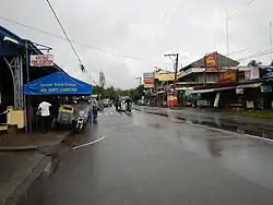 Maharlika Highway | |
 Seal | |
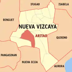 Map of Nueva Vizcaya with Aritao highlighted | |
OpenStreetMap 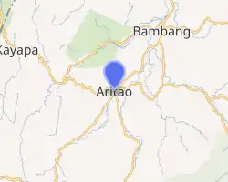
| |
.svg.png.webp) Aritao Location within the Philippines | |
| Coordinates: 16°17′50″N 121°02′02″E | |
| Country | |
| Region | Cagayan Valley (Region II) |
| Province | Nueva Vizcaya |
| District | Lone district |
| Barangays | 22 see Barangays) |
| Government | |
| • Type | Sangguniang Bayan |
| • Mayor | Remelina M. Peros |
| • Vice Mayor | Ruben M. Sayo |
| • Representative | Luisa L. Cuaresma |
| • Electorate | 23,405 voters (2019) |
| Area | |
| • Total | 265.60 km2 (102.55 sq mi) |
| Elevation | 476 m (1,562 ft) |
| Population | |
| • Total | 37,225 |
| • Density | 140/km2 (360/sq mi) |
| • Households | 8,501 |
| Economy | |
| • Income class | 2nd municipal income class |
| • Poverty incidence | 16.51% (2015)[4] |
| • Revenue | ₱138,114,145.29 (2016) |
| Time zone | UTC+8 (PST) |
| ZIP code | 3704 |
| PSGC | |
| IDD : area code | +63 (0)78 |
| Climate type | tropical rainforest climate |
| Native languages | Gaddang Ilocano Isinai Kallahan language Tagalog |
| Website | aritao |
The ethnic minority called Isinai (the same term for the local spoken dialect) were the original residents of this town.
Etymology
The name Aritao came from the Isinai phrase Ari Tau "which stands for "Our King" (ari=king and tau=our) which refers to the legendary Isinai Chieftain Mengal, a fierce and brave king who resisted Spanish conquest of the Isinai territories around Ajanas and Ynordenan (the areas comprising what is now most of Aritao).
History
The town of Aritao was previously called “Ajanas”. This name was later changed to Aritao, after an Isinay word “Ari-Tau”. In January 1767, the intrepid Fr. Manuel Corripio, a Spanish Missionary succeeded in persuading an Igorot King called Ari Mengal and his tribe to live in the lowland, which is the seat of the Municipality of Aritao. These people were later converted into Christianity by Fr. Tomas Gutierrez. In the year 1777, there was a merging of Aritao with the adjacent places into one pueblo under the name of Aritao, which was approved by the Manila Authorities. On 30 June 1917, through the initiative of Councilor Jose Aleman, the application for township of Aritao to higher authorities was finally approved by the Secretary of the Interior.
Barangays
Aritao is politically subdivided into 22 barangays.
- Banganan
- Beti
- Bone North
- Bone South
- Calitlitan
- Comon
- Cutar
- Darapidap
- Kirang
- Nagcuartelan
- Poblacion
- Santa Clara
- Tabueng
- Tucanon
- Anayo
- Baan
- Balite
- Canabuan
- Canarem
- Latar-Nocnoc-San Francisco
- Ocao-Capiniaan
- Yaway
History
In 1942, Japanese troops entered Aritao, Nueva Vizcaya.
A monument to the gallantry of the Japanese and Filipino soldiers during World War II, located at Barangay Kirang, municipality of Aritao, Nueva Vizcaya. Built in 1978 by the Rakunsankai Society of Japan, it was recently rebuilt using a black glazed stone, and a memorial was engraved in the tablet in Japanese and English. Also offers a scenic view of reforested mountains and hills.
Demographics
| Year | Pop. | ±% p.a. |
|---|---|---|
| 1903 | 477 | — |
| 1918 | 1,314 | +6.99% |
| 1939 | 6,208 | +7.67% |
| 1948 | 7,322 | +1.85% |
| 1960 | 11,209 | +3.61% |
| 1970 | 18,098 | +4.90% |
| 1975 | 19,075 | +1.06% |
| 1980 | 22,004 | +2.90% |
| 1990 | 25,942 | +1.66% |
| 1995 | 29,151 | +2.21% |
| 2000 | 31,705 | +1.82% |
| 2007 | 34,206 | +1.05% |
| 2010 | 37,115 | +3.01% |
| 2015 | 37,225 | +0.06% |
| Source: Philippine Statistics Authority [3] [5] [6][7] | ||
Schools
- Aritao National High School
- Immaculate Conception Academy
- Saint Teresita's Academy
- Nueva Vizcaya Institute
- Santa Clara High School
Aritao also has a lot of schools for primary (elementary education).
Images
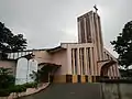
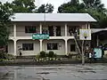 Nueva Vizcaya Institute
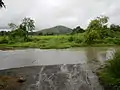 Twin (Skull and Salakot) mountains (visible from Aritao Townhall)
References
- Municipality of Aritao | (DILG)
- "Province: Nueva Vizcaya". PSGC Interactive. Quezon City, Philippines: Philippine Statistics Authority. Retrieved 12 November 2016.
- Census of Population (2015). "Region II (Cagayan Valley)". Total Population by Province, City, Municipality and Barangay. PSA. Retrieved 20 June 2016.
- "PSA releases the 2015 Municipal and City Level Poverty Estimates". Quezon City, Philippines. Retrieved 1 January 2020.
- Census of Population and Housing (2010). "Region II (Cagayan Valley)". Total Population by Province, City, Municipality and Barangay. NSO. Retrieved 29 June 2016.
- Censuses of Population (1903–2007). "Region II (Cagayan Valley)". Table 1. Population Enumerated in Various Censuses by Province/Highly Urbanized City: 1903 to 2007. NSO.
- "Province of Nueva Vizcaya". Municipality Population Data. Local Water Utilities Administration Research Division. Retrieved 17 December 2016.
External links
| Wikimedia Commons has media related to Aritao, Nueva Vizcaya. |
- Aritao Profile at PhilAtlas.com
- Philippine Standard Geographic Code
- Philippine Census Information
- Local Governance Performance Management System
Places adjacent to Aritao | |
|---|---|