Arivonimamo
Arivonimamo is a city (commune urbaine) in Itasy Region, in the Central Highlands of Madagascar.
Arivonimamo | |
|---|---|
commune urbaine | |
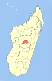
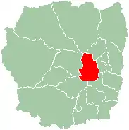 Map of former Antananarivo Province showing the location of Arivonimamo district (red). | |
| Country | Madagascar |
| Region | Itasy |
Arivonimamo is connected by the national road RN 1 to Antananarivo (east) and Tsiroanomandidy (west). The Antananarivo international airport was there until replaced by Ivato in 1967. Now it is an airbase.
Politics
During the 1980s, the IMF imposed harsh austerity measures across Madagascar, leading to the cutting of a mosquito net program which was linked to an outbreak of malaria which killed thousands of people.[1] As well as the withdrawal of police, soldiers and government bureaucrats from the region. Following this, an anarchist community formed which made decisions via consensus which David Graeber argues led to a very low crime rate.[2]
Climate
| Climate data for Arivonimamo | |||||||||||||
|---|---|---|---|---|---|---|---|---|---|---|---|---|---|
| Month | Jan | Feb | Mar | Apr | May | Jun | Jul | Aug | Sep | Oct | Nov | Dec | Year |
| Average high °C (°F) | 26 (79) |
26 (78) |
25 (77) |
25 (77) |
23 (73) |
21 (70) |
20 (68) |
22 (71) |
23 (74) |
26 (78) |
26 (79) |
26 (79) |
24 (75) |
| Average low °C (°F) | 15 (59) |
14 (58) |
15 (59) |
13 (55) |
11 (51) |
8 (47) |
8 (46) |
8 (46) |
9 (48) |
11 (52) |
13 (56) |
14 (58) |
12 (53) |
| Average precipitation mm (inches) | 330 (12.8) |
210 (8.2) |
220 (8.6) |
36 (1.4) |
18 (0.7) |
10 (0.4) |
5.1 (0.2) |
13 (0.5) |
5.1 (0.2) |
64 (2.5) |
130 (5.1) |
210 (8.3) |
1,240 (48.8) |
| Source: Weatherbase [3] | |||||||||||||
Sports
The soccer club of Arivonimamo is RDN Arivonimamo[4]
References
- Graeber, David (2011). Debt: The First 5000 Years.
- Graeber, David (2007). Possibilities: Essays on Hierarchy, Rebellion, and Desire. AK Press. pp. 157–180.
- "Weatherbase: Historical Weather for Arivonimamo, Madagascar". Weatherbase. 2011. Retrieved on November 24, 2011.
- fr.soccerway.com