Arizona State Route 210
State Route 210 (SR 210), also known as the Barraza-Aviation Parkway, is a state highway located in Tucson, Arizona, alongside the Union Pacific railroad. Most of it was opened around 1998.
| ||||
|---|---|---|---|---|
| Barraza-Aviation Parkway | ||||
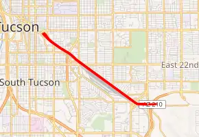
SR 210 highlighted in red | ||||
| Route information | ||||
| Maintained by ADOT | ||||
| Length | 3.96 mi[1] (6.37 km) | |||
| Existed | 1998–present | |||
| Major junctions | ||||
| West end | Broadway Boulevard in Tucson | |||
| East end | Golf Links Road in Tucson | |||
| Highway system | ||||
| ||||

Route description
Between its western terminus at Broadway Boulevard and Kino Parkway, SR 210 is a controlled-access expressway; farther east, it is a limited-access highway with at-grade intersections and traffic lights until its eastern terminus at Golf Links Road (at the western edge of Davis-Monthan Air Force Base).
SR 210 currently does not intersect any other state or national routes, but is planned to intersect Interstate 10 in the future.[1][2]
History
The initial section of SR 210 has a very long history in Tucson. Called the Barraza-Aviation Highway, all but the last few miles were completed in the 1990s. On July 8, 2008, the Mayor and Council voted 6–0 to approve Alignment 3.d., which would extend SR 210 to I-10 at the current St. Mary's Road overpass.[3][4]
According to historian David Leighton of the Arizona Daily Star newspaper, the name "Barraza" is named for union leader Maclovio R. Barraza and the word "Aviation" derives from the Aviation Field, now called Davis-Monthan Air Force Base.[5]
Future
After the passage of the Regional Transportation Authority plan, a portion of the sales tax increase will pay for an extension of the parkway from Broadway Blvd. to 6th Street. The plan is called Downtown Links. The road will go alongside the Union Pacific Railroad. Also, the railroad crossing on 6th St., west of Stone Avenue, will be improved, providing a new overpass above the railroad. This will allow direct access from I-10 to the new parkway via 6th Street.[6]
The parkway will be four lanes wide. Construction in the second phase of the RTA plan had been scheduled to start in 2020.[3]
ADOT is undergoing a study to connect SR 210 to I-10 at Alvernon Way, Valencia Road, or Wilmot Road in southeast Tucson.[7] The new roadway would be built to freeway standards from I-10 to the current terminus at Golf Links Road.[8]
Exit list
The entire route is in Tucson, Pima County.
| mi[1] | km | Exit | Destinations | Notes | |
|---|---|---|---|---|---|
| 0.00 | 0.00 | Future western terminus; roadway to continue west as St. Mary's Road | |||
| 1.00 | 1.61 | 2 | Broadway Boulevard | At-grade intersection; temporary west end | |
| 2.36 | 3.80 | 3 | South Kino Parkway | ||
| 2.88 | 4.63 | 4 | 22nd Street east | Interchange westbound, at-grade intersection eastbound; no eastbound entrance | |
| 4.78 | 7.69 | — | Alvernon Way | ||
| Golf Links Road | Interchange; eastern terminus | ||||
1.000 mi = 1.609 km; 1.000 km = 0.621 mi
| |||||
References
- Arizona Department of Transportation. "2013 ADOT Highway Log" (PDF). Retrieved December 23, 2015.
- Google (April 14, 2008). "overview map of SR 210" (Map). Google Maps. Google. Retrieved April 14, 2008.
- "Downtown Links Home".
- O'Dell, Rob (July 9, 2008). "Aviation Parkway extension route OK'd; Rio Nuevo is moving ahead". Arizona Daily Star. Lee Enterprises. Retrieved December 23, 2015.
- Leighton, David (August 10, 2015). "Street Smarts: Barraza worked to unify Arizona miners". Arizona Daily Star. Lee Enterprises.
- http://www.downtownlinks.info/wp-content/uploads/LINKS-PHASE-3-ROLL-PLOT_April-2017-1.pdf
- "Interstate 10 and State Route 210 Feasibility Study". Azdot.gov. October 6, 2011. Retrieved June 7, 2012.
- http://www.azdot.gov/highways/projects/I10_SR210_Study/PDF/I10_SR210_Feasibility_MeetingHandout_100611.pdf