List of Interstate Highways in Arizona
| Interstate Highways of the Arizona State Highway System | |
|---|---|
.svg.png.webp) .svg.png.webp)  Example signage from Arizona's Interstate System | |
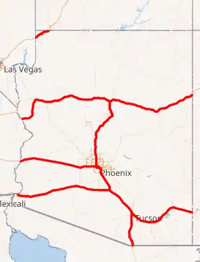
Interstate Highways highlighted in red | |
| System information | |
| Maintained by ADOT | |
| Length | 1,169.17 mi[1] (1,881.60 km) Interstate Business Routes not included |
| Formed | 1957 |
| Highway names | |
| Interstates | Interstate X (I-X) |
| US Highways | U.S. Route X (US X) |
| State | State Route X (SR X) |
| System links | |
The U.S. state of Arizona's Interstate Highways.
List
| Number | Length (mi)[1] | Length (km) | Southern or western terminus | Northern or eastern terminus | Formed | Removed | Notes | |
|---|---|---|---|---|---|---|---|---|
| 178.33 | 286.99 | I-8 at the California state line | I-10 in Casa Grande | 1962[2] | current | Replaced US 80 and SR 84 | ||
| 392.33 | 631.39 | I-10 at the California state line | I-10 at the New Mexico state line | 1960[3] | current | Replaced US 60, US 70, SR 93, SR 84, US 80 and SR 86 | ||
| — | — | I-19 BL in Nogales | I-11/US 93 at the Nevada state line | proposed | — | Will replace US 93 and I-19 | ||
| 29.39 | 47.30 | I-15 at the Nevada state line | I-15 at the Utah state line | 1962[4] | current | Replaced US 91 | ||
| 145.76 | 234.58 | I-10 / US 60 in Phoenix | I-40 in Flagstaff | 1957[5] | current | Replaced US 89, US 89A, SR 79 and SR 69 | ||
| 63.35 | 101.95 | I-19 Bus. in Nogales | I-10 at Tucson | 1963[6] | current | Replaced US 89 and SR 93 | ||
| 359.48 | 578.53 | I-40 at the California state line | I-40 at the New Mexico state line | 1962[6] | current | Replaces US 66 and US 89 | ||
| 0.65[7] | 1.05 | I-10 in Phoenix | Buckeye Road in Phoenix | 1969[8] | 1971[9] | Renumbered I-10; old route of I-10 became I-17 | ||
| 0.65[7] | 1.05 | I-10 in Phoenix | Buckeye Road in Phoenix | 1958[10] | 1969[8] | Inner Loop Freeway; only a small section was completed; renumbered I-410 | ||
| — | — | I-10 in Tucson | I-10 in Tucson | 1971 | 1982 | Proposed, but it never materialized. What would have been I-710 became today's Kino Parkway. | ||
| ||||||||
Business routes
All state designated Interstate Business Loops are internally designated as State Route Business Loops by ADOT, being referred to throughout ADOT ArcGIS data and state highway logs as such.[11] For example, all currently state designated I-10 Business Loops in Arizona are referred to as "SB010" which is the Arizona Transportation Information System (ATIS) code for "State Business Route 10" or "SR 10B" for short.[11][12]
| Number | Length (mi)[1] | Length (km) | Southern or western terminus | Northern or eastern terminus | Formed | Removed | Notes | |
|---|---|---|---|---|---|---|---|---|
| 12.23 | 19.68 | I-8 BL at the California state line | I-8 east of Yuma | 1966[13] | current | Former US 80[14] | ||
| 5.96 | 9.59 | I-8 west of Gila Bend | I-8 east of Gila Bend | 1973[15] | current | Former US 80 and SR 84[14] | ||
| 2.91 | 4.68 | I-10 west of Quartzsite | I-10 east of Quartzsite | 1974[16] | current | Former US 60/US 70[14] | ||
| — | — | I-10 at 27th Avenue in Phoenix | I-10 at 48th Street in Phoenix | — | 1990 | |||
| 5.75[6] | 9.25 | I-10 and Park Avenue in Tucson | I-10 east of Tucson | 1972[17] | 2001[18] | Former US 80/SR 86[14] | ||
| 3.51 | 5.65 | I-10 west of Benson | I-10 east of Benson | 1974[19] | current | Former US 80/SR 86[14] | ||
| 0.55[6] | 0.89 | I-10 north of Benson | I-10 BL in Benson | 1969[20] | 1999[21] | Ocotillo Road in Benson | ||
| 8.33 | 13.41 | I-10 west of Willcox | I-10 east of Willcox | 1974[22] | current | Former US 666/SR 86[14] | ||
| 4.41 | 7.10 | I-10 west of Bowie | I-10 east of Bowie | 1974[23] | current | Former SR 86[14] | ||
| 3.90 | 6.28 | I-10 west of San Simon | I-10 east of San Simon | 1974[24] | current | Former SR 86[14] | ||
| 17.06 | 27.46 | I-19 north of Nogales | Fed. 15 at the Mexican border | 1992[25] | current | Former US 89[14] | ||
| 20.24[6] | 32.57 | I-19 in Green Valley | I-10 in South Tucson | 1992[26] | 2004[27] | Former US 89/SR 93[14] | ||
| 0.55[lower-alpha 1] | 0.89 | I-40/US 93 west of Kingman | I-40/US 93 east of Kingman | 1984[28] | 2009[29] | Former US 66/US 93[14] | ||
| 4.25 | 6.84 | I-40 southwest of Seligman | I-40 southeast of Seligman | 1984[30] | current | Section of the route is former US 66.[14] | ||
| 1.49 | 2.40 | I-40 west of Ash Fork | I-40/SR 89 east of Ash Fork | 1984[31] | current | Former US 66/US 89.[14] | ||
| 24.08 | 38.75 | I-40 west of Flagstaff | I-40/US 180 east of Flagstaff | 1984[31] | current | Former US 66/US 89.[14] | ||
| 0.87[32] | 1.40 | I-40 BL/US 180 in Flagstaff | I-40/US 180 east of Flagstaff | 2002[33] | 2008[34] | Former US 66/US 180.[14] | ||
| 3.63[35] | 5.84 | I-40/US 180/SR 99 west of Winslow | I-40/US 180/SR 87 east of Winslow | 1980[36] | 2007[32] | Former US 66/US 180.[14] | ||
| 1.20 | 1.93 | SR 99 (3rd Street) in Winslow | Winslow Industrial Spur west of Winslow | 1974[37] | current | Former US 66/US 180.[14] | ||
| 6.83 | 10.99 | I-40/US 180 west of Joseph City | I-40/US 180 east of Joseph City | 1984 | current | Former US 66/US 180.[14] | ||
| 15.47 | 24.90 | I-40/US 180 west of Holbrook | I-40/SR 77 east of Holbrook | 1984 | current | Former US 66.[14] | ||
| ||||||||
See also
 Arizona portal
 U.S. roads portal
References
- Arizona Department of Transportation. "2008 ADOT Highway Log" (PDF). Arizona Department of Transportation. Retrieved April 30, 2008.
- Cole, Ben (May 1, 1963). "State Road Jobs Eyed by House". Arizona Republic. Phoenix. pp. 1, 4. Retrieved June 10, 2019 – via Newspapers.com.
- Harelson, Hugh (December 4, 1960). "$3 Million Road Budget Explained". Arizona Republic. Phoenix. p. 17. Retrieved October 6, 2018 – via Newspapers.com.

- Arizona Department of Transportation (February 28, 2015). "Arizona State Highway System Bridge Record" (PDF). Arizona Department of Transportation. Retrieved September 10, 2016.
- Nothaft, Mark (February 21, 2017). "Which freeway came first in the Valley?". Arizona Republic. Retrieved June 18, 2019 – via AZCentral.com.
- Arizona Department of Transportation (December 15, 1999). "1998 State Highway System Log" (PDF). Arizona Department of Transportation. Retrieved June 10, 2019.
- "NETRonline: Historic Aerials - Viewer". NETR Online. Tempe, Arizona: Nationwide Environmental Title Research, LLC. September 10, 2018. Retrieved September 10, 2018.
- Breyer, Joe. "Arizona DOT Right-of-Way Resolution 1962-151". Arizona Highway Data. Works Consulting, LLC. Retrieved March 6, 2016.
- Arizona Department of Transportation (1971). ADOT Road Map of Arizona (Map). No Scale Given. Phoenix: Arizona Highway Department. Phoenix inset. Retrieved August 24, 2018 – via AARoads.
- Breyer, Joe. "Arizona DOT Right-of-Way Resolution 1962-151". Arizona Highway Data. Works Consulting, LLC. Retrieved March 6, 2016.
- Arizona Department of Transportation, Multimodal Planning Division (2015). "State Highway System (ArcGIS)". Arizona Department of Transportation. Retrieved August 1, 2018.
- "ATIS Nomenclature" (PDF). GPS Tools for Arc View. Arizona Department of Transportation. August 2, 2000. pp. 57 to 64.
- Arizona Department of Transportation. "ADOT Right-of-Way Resolution 1966-P-075". Arizona Department of Transportation. Retrieved October 18, 2018.
- Arizona Highway Department; Rand McNally Company (1963). State Highway Department Road Map of Arizona (Map). 1:1,520,640. Phoenix: Arizona Highway Department. Retrieved August 24, 2018 – via AARoads.
- Arizona Department of Transportation. "ADOT Right-of-Way Resolution 1973-P-074". Arizona Department of Transportation. Retrieved October 18, 2018.
- Arizona Department of Transportation. "ADOT Right-of-Way Resolution 1974-P-056". Arizona Department of Transportation. Retrieved October 18, 2018.
- Arizona Department of Transportation. "ADOT Right-of-Way Resolution 1972-P-082". Arizona Department of Transportation. Retrieved October 18, 2018.
- Arizona Department of Transportation. "ADOT Right-of-Way Resolution 2001-8-A-060". Arizona Department of Transportation. Retrieved October 18, 2018.
- Arizona Department of Transportation. "ADOT Right-of-Way Resolution 1974-P-060". Arizona Department of Transportation. Retrieved October 18, 2018.
- Staff. "ADOT Right-of-Way Resolution 1969-P-063". Arizona Department of Transportation. Retrieved June 19, 2019.
- Staff. "ADOT Right-of-Way Resolution 1999-11-A-053". Arizona Department of Transportation. Retrieved June 19, 2019.
- Arizona Department of Transportation. "ADOT Right-of-Way Resolution 1974-P-059". Arizona Department of Transportation. Retrieved October 18, 2018.
- Arizona Department of Transportation. "ADOT Right-of-Way Resolution 1974-P-057". Arizona Department of Transportation. Retrieved October 18, 2018.
- Arizona Department of Transportation. "ADOT Right-of-Way Resolution 1974-P-058". Arizona Department of Transportation. Retrieved October 18, 2018.
- Arizona Department of Transportationg. "ADOT Right-of-Way Resolution 1992-08-A-056". Arizona Department of Transportation. Retrieved October 18, 2018.
- Arizona Department of Transportation. "ADOT Right-of-Way Resolution 1992-08-A-056". Arizona Department of Transportation. Retrieved October 18, 2018.
RENUMBER U.S. 89 FROM JCT WITH I-19 NEAR GREEN VALLEY TO I-10 IN TUCSON
- Arizona Department of Transportation. "ADOT Right-of-Way Resolution 2004-03-A-009". Arizona Department of Transportation. Retrieved October 18, 2018.
Abandon B-19 (old 89) from Duval Mine Road going north to Los Reales Road; Portion goes to Pima County, portion goes to the Town of Sahuarita; PR: 9-9-27, p. 26; + various; and 92-08-A-56.
- Arizona Department of Transportation. "ADOT Right-of-Way Resolution 1984-10-A-063". Arizona Department of Transportation. Retrieved June 5, 2019.
- Multimodal Planning Division, Roadway Inventory Staff (December 31, 2009). "2009 State Highway System Log" (PDF). Arizona Department of Transportation. Retrieved June 5, 2019.
- Arizona Department of Transportation. "ADOT Right-of-Way Resolution 1984-10-A-064". Arizona Department of Transportation. Retrieved June 5, 2019.
- Arizona Department of Transportation. "ADOT Right-of-Way Resolution 1984-10-A-064". Arizona Department of Transportation. Retrieved June 5, 2019.
- Arizona Department of Transportation (December 31, 2007). "2007 State Highway System Log" (PDF). Arizona Department of Transportation. Retrieved June 5, 2019.
- Arizona Department of Transportation (December 31, 2005). "2005 State Highway System Log" (PDF). Arizona Department of Transportation. Retrieved June 5, 2019.
- Multimodal Planning Division, Data Bureau Staff (December 31, 2008). "2008 State Highway System Log" (PDF). Arizona Department of Transportation. Retrieved June 5, 2019.
- Transportation Planning Division, Data Bureau Staff (December 31, 2006). "2006 State Highway System Log" (PDF). Arizona Department of Transportation. Retrieved June 5, 2019.
- Arizona Department of Transportation. "ADOT Right-of-Way Resolution 1980-10-A-040". Arizona Department of Transportation. Retrieved June 5, 2019.
- Arizona Department of Transportation. "ADOT Right-of-Way Resolution 1974-03-A-001". Arizona Department of Transportation. Retrieved June 5, 2019.
Notes
- Only the beginning and ending segments of BL 40 were maintained by ADOT at the very end of its existence, hence the low recorded mileage.
This article is issued from Wikipedia. The text is licensed under Creative Commons - Attribution - Sharealike. Additional terms may apply for the media files.