Arsky District
Arsky District (Russian: А́рский райо́н; Tatar: Арча районы) – is a territorial administrative unit and municipal district of the Republic of Tatarstan within the Russian Federation. The district is located in the northern part of the republic. The administrative center is the city of Arsk.[4]
Arsky District
Арский район | |
|---|---|
| Other transcription(s) | |
| • Tatar | Арча районы |
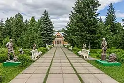 Forest Tukai-Kyrlay, Arsky District | |
 Flag | |
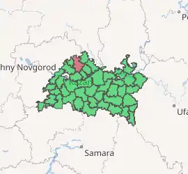
Location of Arsky District in the Republic of Tatarstan | |
| Coordinates: 56°12′N 49°51′E | |
| Country | Russia |
| Federal subject | Tatarstan |
| Established | September 10, 1930 |
| Administrative center | Arsk |
| Area | |
| • Total | 1,843.6 km2 (711.8 sq mi) |
| Population | |
| • Total | 51,667 |
| • Estimate (2018)[2] | 52,265 (+1.2%) |
| • Density | 28/km2 (73/sq mi) |
| • Urban | 35.1% |
| • Rural | 64.9% |
| Administrative structure | |
| • Inhabited localities | 1 Cities/towns, 127 Rural localities |
| Municipal structure | |
| • Municipally incorporated as | Arsky Municipal District |
| • Municipal divisions | 1 Urban settlements, 16 Rural settlements |
| Time zone | UTC+3 (MSK |
| OKTMO ID | 92612000 |
| Website | http://arsk.tatarstan.ru/ |
The district has several natural monuments, such as the source of the Kazanka river, Yanga-Salinsky slope, Korsin colony of grey heron, Tukai-kyrlay forest, Ayu Urmany, Kazanka and Shoshma rivers.[5]
Geography
The Arsk district is one of the largest districts of the Republic of Tatarstan with the total area of 1,843.7 km². Several highways connecting Kazan with the Kirov region, Udmurtia and Perm Oblast cross the district. The Arsky District borders the Baltasinsky, Sabinsky, Tyulyachinsky, Pestrechinsky, Vysokogorsky, Atninsky districts of Tatarstan and the Republic of Mari El (Mari-Tureksky District and Morkinsky District).[6][7]
The relief of the region is a hilly plain (height 170-266 m), dissected by the valleys of the Kazanka rivers (tributaries: Atynka, Verezinka, Oya, Kismes), Ashit, and Shoshma. Forests cover about 12% of the area.
The administrative center of the district is located in 60 km from Kazan.[4]
Coat of arms
The coat of arms of the Arsk district was approved at the meeting of the Arsk District Council on March 17, 2006. It is made in the form of a green shield with the image of a golden fortress, asters and ears of corn, symbolizing agricultural focus of the district. The flag of Arsk region is based on the image of the coat of arms and has a rectangular shape with the same embodiment depicted on it.[8]
History
Arsk has been known since the XII-XIII centuries as a Bulgar fortress. The first mention of the settlement was discovered in Russian chronicles describing the conquest of the Kazan throne by the Siberian Khan Mamuk in 1496-1497. In 1552, the troops of the governor Alexander Gorbatyi-Shuisky and Andrey Kurbsky burned the city. Three years later, a Russian fortress was erected in its place.[9][10]
In 1781-1796, Arsk had the status of a district town (or uyezd) of the Kazan governorship, then a provincial town of the Kazan district. In the 18th - early 19th centuries, its lands were inhabited by settlements of arable soldiers who engaged in agriculture, cattle breeding, blacksmith, brick and other trades.[9]
Until 1920, the territory of the modern Arsk district was part of the Kazan district of the Kazan Province. From 1920 to 1930, these territories belonged to the Arsk canton. Arsk district was formed on August 10, 1930. At that time, it included 64 villages and 113 settlements with overall amount of 64 136 residents.[4][11]
From 2006 to 2014 the head of the district was Almas Nazirov. Since 2015, this position has been held by Ilshtat Nuriev. The Executive Committee is headed by Rasul Mukharyamov[12][13]
Population
As of 2020, 51 291 people reside in the district. Ethnic compositon of the district is 92,8 % Tatars, Russians, and 0,5 % Mari people.[14]
Municipal-territorial structure
Arsk municipal district has one urban and 16 rural settlements and 128 settlements. In 2010, the Law of the Republic of Tatarstan No. 18-ZRT united the "city of Arsk" and "Tyubyak-Chekurchinskoe rural settlement" into the municipal formation "city of Arsk", and the villages of Ak-Chishma and Naratlyk, which were part of the Shushmabash rural settlement, and the village the adjacent territory was assigned to the Tashkichi rural settlement.[14]
Economy
State of the Art
For 2020, the Arsk district occupies the 35th position (out of 43) in the ranking evaluating the quality of life among Tatarstan municipalities. The district has a severe problem with infrastructure as around 127 settlements do not have sewerage while 59% of all roads are in poor condition.[15]
Agriculture constitutes the main part of the district economy. Residents are engaged in fish farming, meat and dairy cattle breeding, sheep breeding. Besides, peat, loose limestone and dolomite are mined in the area. Large enterprises include Arskiy kirpichniy zavod, Arskiy elevator, Arsknefteprodukt, Arskiy Rybkhoz, Arskiy Dairy Plant.[9][16]
Investment potential
In 2019 Arsk district attracted 404 mln rubbles of investment (in addition to budget funds and small business).[17] As of the first half of 2020, the region's investments in the fixed capital of the region for the full range of economic entities amount to 865 million rubles, or 0.4% of the total investment in the republic. In the first half of 2020, more than 7 000 m2 of housing were commissioned in the Arsk region. Most of the area is occupied by the population while commercial area constitutes only 402 m2.[18]
Since 2019, the Arsk agro-industrial park with an area of 21 hectares is being built in the district. The Sozidanie company is investing in the project; the volume of investments amounts to 140 million rubles. It is expected that the park will be equipped with shops for receiving and processing milk, processing vegetables and producing juices, a meat processing complex, and production of protein-vitamin mineral supplements. It is planned to attract five residents to the industrial park, which will create at least 300 jobs.[19][20]
Transport
The total length of roads in the region is 1101.2 km. The Kazan - Yekaterinburg railway, the Kazan - Perm, Bolshaya Atnya - Arsk and Arsk - Novy Kiner highways pass through its territory.[21]
Social area
As for 2020, there are 105 secondary schools, a children's art school, a children's and youth sports school "Archa", three libraries and a schoolchildren's palace operate in the Arsk district. In the sphere of culture, there are 78 recreational centers and other clubs, 57 libraries and eight museums. Among the regional newspapers "Archa khuburlure" ("Arskiy Vestnik"), which is published in Russian and Tatar languages.[9][22][4]
References
- Russian Federal State Statistics Service (2011). "Всероссийская перепись населения 2010 года. Том 1" [2010 All-Russian Population Census, vol. 1]. Всероссийская перепись населения 2010 года [2010 All-Russia Population Census] (in Russian). Federal State Statistics Service.
- "26. Численность постоянного населения Российской Федерации по муниципальным образованиям на 1 января 2018 года". Federal State Statistics Service. Retrieved January 23, 2019.
- "Об исчислении времени". Официальный интернет-портал правовой информации (in Russian). June 3, 2011. Retrieved January 19, 2019.
- Экологический гид 2015, p. 78.
- Экологический гид 2015, p. 78—80.
- "Арский район: знаменитые "университеты" и родина татарского капитализма". Реальное время. March 4, 2018. Retrieved November 17, 2020.
- Руденко 2013, p. 116.
- Историко-культурный атлас 2013, p. 43.
- "Арский район: деревни ханской даруги, место учебы Шаляпина и "дивный край"" [Arsky district: villages of the khan daruga, the place of study of Shalyapin and the "wonderful land".]. Реальное время. February 26, 2018. Retrieved November 17, 2020.
- Историко-культурный атлас 2013, p. 7.
- Историко-культурный атлас 2013, p. 4—5.
- "Назиров Алмас Аминович". Реальное время. Retrieved November 17, 2020.
- "Органы управления Арского муниципального района". Официальный сайт Арского район. Retrieved November 17, 2020.
- "Где в Татарстане жить хорошо: рейтинг районов республики по качеству жизни" [Where to live well in Tatarstan: the rating of regions of the republic in terms of quality of life]. Inkazan.ru. March 16, 2020. Retrieved November 17, 2020.
- Историко-культурный атлас 2013, p. 30.
- "Основные показатели инвестиционной и строительной деятельности в Республике Татарстан" (PDF). Территориальный орган Федеральной службы государственной статистики по Республике Татарстан. 2020. Retrieved December 9, 2020.
- "Основные показатели инвестиционной и строительной деятельности в Республике Татарстан" [Key indicators of investment and construction activities in the Republic of Tatarstan] (PDF). Территориальный орган Федеральной Службы государственной статистики по Республике Татарстан. 2020. Retrieved December 9, 2020.
- "В Татарстане достроят промпарки в Арске, Буинске и Уруссу в 2019 году" [Industrial parks to be completed in Tatarstan in Arsk, Buinsk and Urussa in 2019]. TatCenter.ru. January 28, 2019.
- "Промышленный парк "Арский" готовит рабочие места" [Industrial park "Arsky" prepares jobs]. Taтмедиа. September 20, 2020. Retrieved November 17, 2020.
- Историко-культурный атлас 2013, p. 34.
- "Арский район". TatCenter.ru. Retrieved November 17, 2020.
Sources
- Зиганшин И. И., Иванов Д. В., Томаева И. Ф. (2015). Д. В. Иванов (ed.). Экологический гид по зелёным уголкам Республики Татарстан. Казань: Фолиант.CS1 maint: multiple names: authors list (link)
- Руденко К. А., Шутова Н. И. (2013). "История археологического изучения Арского района республики Татарстан". 1 (21). Вестник Пермского университета. pp. 116–120.
- Салихов Р. Р. , Ногманов А. И., Каримов И. Р. (2013). Историко-культурный атлас Арского района Республики Татарстан. Пенза: ИП Рогожин И. В. p. 100.CS1 maint: multiple names: authors list (link)
External links
| Authority control |
|
|---|