Assab
Assab or Aseb is a port city in the Southern Red Sea Region of Eritrea. It is situated on the west coast of the Red Sea. Languages spoken in Assab are predominantly Afar, Tigrinya, and Arabic.[1] Assab is known for its large market, beaches and nightlife.
Assab
Assab | |
|---|---|
City | |
 Church of St.Michael, Assab | |
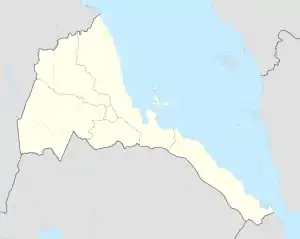 Assab Location in Eritrea | |
| Coordinates: 13°00′28″N 42°44′28″E | |
| Country | |
| Region | Southern Red Sea |
| District | Southern Denkalya |
| Elevation | 16 m (52 ft) |
| Population (2005) | |
| • Total | 20,222 |
| Climate | BWh |
History
The site of the ancient city of Arsinoe is near Assab.
On 15 November 1869 the port of Assab was bought by the Rubattino Shipping Company of Italy from the local Sultan.[2] After the Italian government took over control of the port in 5 July 1882 it laid the foundations for the formation of the colony of Italian Eritrea, which became the independent country of Eritrea.
Construction of an oil refinery began in 1964 and it opened in 1967. By 1989, Assab had a population of 39,600 inhabitants. The port facilities were greatly expanded in the early 1990s, with the construction of a new terminal. The oil refinery was shut down for economic reasons in 1997. Ethiopia used Assab as the port for two-thirds of its trade with the world until the Eritrean–Ethiopian War broke out in 1998. Borders between Eritrea and Ethiopia closed and trade with Ethiopia ceased. The port and the port town declined and by 2005 the population had dropped to an estimated 20,222 inhabitants.
21st Century
In 2008, following a border dispute with neighbouring Djibouti and consequently an unsafe border between the countries, which saw forces from Qatar acting as mediators in a buffer zone, the role of Assab diminished further.
During the 2020-2021 Tigray War, Assab was also involved. Offensives of joint ENDF-Amhara-Eritrean forces into Tigray were facilitated by the intervention of "Pterosaurus" drones, launched by the United Arab Emirates from its base in Assab. The chinese-made armed drones bombed Tigrayan towns and defence forces.[3] EEPA has provided a summarised translation of the Chinese article.[4] On 19 December 2020, an EEPA report mentioned that Egyptian officials and a European diplomat state that the UAE have used its base in Assab to launch armed drone strikes against Tigray. The investigative platform Bellingcat further confirmed the presence of Chinese-produced drones at the UAE’s military base in Assab.[5]
Infrastructure
Assab is served by Assab International Airport. The United Arab Emirates reportedly uses the port and airport for logistics, and as a detention center.[6][7]
Climate
Assab has the typical hot desert climate (Köppen climate classification BWh) of the Danakil Region. The city’s climate is arid and extremely hot, with an extremely low average annual rainfall of 40 mm (1.57 in). Assab experiences high temperatures during both the day and the night, with the annual mean average temperature approaching 31 °C (87.8 °F).
| Climate data for Assab (1961–1990, extremes 1937–1990) | |||||||||||||
|---|---|---|---|---|---|---|---|---|---|---|---|---|---|
| Month | Jan | Feb | Mar | Apr | May | Jun | Jul | Aug | Sep | Oct | Nov | Dec | Year |
| Record high °C (°F) | 37.0 (98.6) |
37.0 (98.6) |
40.0 (104.0) |
43.0 (109.4) |
43.2 (109.8) |
46.2 (115.2) |
49.0 (120.2) |
48.4 (119.1) |
46.8 (116.2) |
43.0 (109.4) |
39.0 (102.2) |
36.5 (97.7) |
49.0 (120.2) |
| Average high °C (°F) | 31.3 (88.3) |
31.7 (89.1) |
33.8 (92.8) |
36.0 (96.8) |
37.0 (98.6) |
38.5 (101.3) |
41.2 (106.2) |
40.9 (105.6) |
38.1 (100.6) |
36.5 (97.7) |
33.9 (93.0) |
31.6 (88.9) |
35.5 (95.9) |
| Daily mean °C (°F) | 26.3 (79.3) |
26.7 (80.1) |
28.5 (83.3) |
30.5 (86.9) |
32.0 (89.6) |
33.1 (91.6) |
35.0 (95.0) |
34.6 (94.3) |
32.9 (91.2) |
31.2 (88.2) |
28.8 (83.8) |
26.9 (80.4) |
30.5 (86.9) |
| Average low °C (°F) | 21.3 (70.3) |
21.7 (71.1) |
23.2 (73.8) |
25.1 (77.2) |
27.0 (80.6) |
28.5 (83.3) |
30.3 (86.5) |
29.9 (85.8) |
28.5 (83.3) |
26.0 (78.8) |
23.7 (74.7) |
22.2 (72.0) |
25.6 (78.1) |
| Record low °C (°F) | 11.9 (53.4) |
12.4 (54.3) |
13.7 (56.7) |
14.0 (57.2) |
14.4 (57.9) |
17.5 (63.5) |
19.6 (67.3) |
19.9 (67.8) |
16.0 (60.8) |
15.0 (59.0) |
14.5 (58.1) |
12.1 (53.8) |
11.9 (53.4) |
| Average rainfall mm (inches) | 4.0 (0.16) |
6.7 (0.26) |
1.8 (0.07) |
3.6 (0.14) |
1.7 (0.07) |
0.2 (0.01) |
6.9 (0.27) |
2.8 (0.11) |
1.1 (0.04) |
1.0 (0.04) |
4.5 (0.18) |
4.8 (0.19) |
39.1 (1.54) |
| Average rainy days (≥ 1.0 mm) | 1 | 1 | 0 | 0 | 0 | 0 | 1 | 0 | 0 | 0 | 0 | 0 | 3 |
| Average relative humidity (%) | 62 | 68 | 61 | 54 | 58 | 57 | 50 | 54 | 62 | 54 | 55 | 61 | 58 |
| Source 1: NOAA,[8] Deutscher Wetterdienst (humidity, 1937–1970)[9] | |||||||||||||
| Source 2: Meteo Climat (record highs and lows)[10] | |||||||||||||
References
- Falola, Toyin; Jean-Jacques, Daniel (14 December 2015). Africa: An Encyclopedia of Culture and Society [3 volumes]: An Encyclopedia of Culture and Society. ISBN 9781598846669.
- The Ethiopians: An Introduction to Country and People, second edition (London: Oxford University Press, 1965), p. 90. ISBN 0-19-285061-X.
- YouUAV.com, 4 December 2020
- Situation Report EEPA HORN No. 64 - 23 January 2021
- Situation Report EEPA HORN No. 31 - 20 December Europe External Programme with Africa
- "Has Eritrea's migration problem been exaggerated?". BBC.
- "Yemen: UAE Backs Abusive Local Forces". Human Rights Watch. June 22, 2017.
Human Rights Watch was not able to verify these claims, but according to lawyers and activists, as well as relatives of men who had been disappeared, the UAE was transferring high-level detainees outside of Yemen. According to one of the activists, about 15 people accused of being members of AQAP or IS-Y had been transferred to the base the UAE has been developing in Eritrea’s port city, Assab, over the past two years. A man whose relatives had been disappeared said at least five officials told him the UAE transferred the men outside of Yemen, including three who said the men were being held in Eritrea.
- "Assab Climate Normals 1961–1990". National Oceanic and Atmospheric Administration. Retrieved March 8, 2015.
- "Klimatafel von Assab (Aseb) / Eritrea" (PDF). Baseline climate means (1961-1990) from stations all over the world (in German). Deutscher Wetterdienst. Archived from the original (PDF) on August 31, 2019. Retrieved November 18, 2016.
- "Station Assab" (in French). Meteo Climat. Retrieved 22 October 2016.
External links
- . New International Encyclopedia. 1905.