Astoria–Megler Bridge
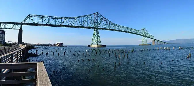
The Astoria–Megler Bridge is a steel cantilever through truss bridge in the northwest United States that spans the lower Columbia River, between Astoria, Oregon, and Point Ellice near Megler, Washington. Opened 55 years ago in 1966, it is the longest continuous truss bridge in North America.
Astoria–Megler Bridge | |
|---|---|
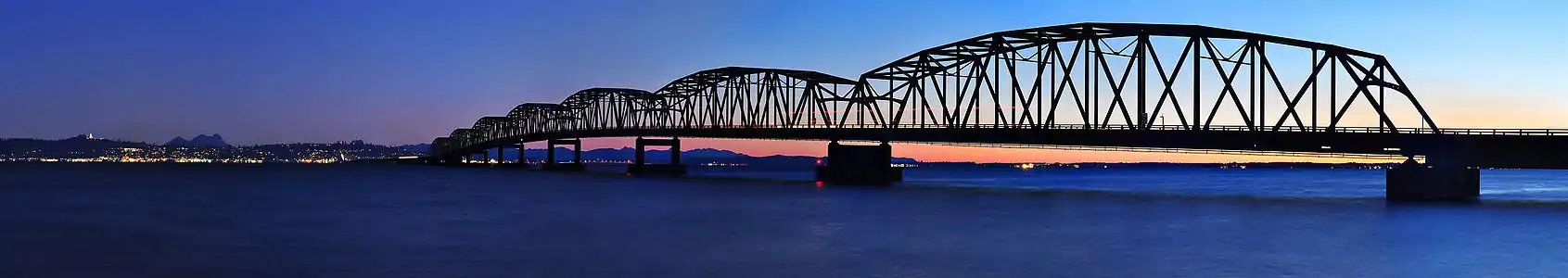
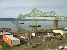 Viewed from the Astoria side of the Columbia River | |
| Coordinates | 46.217°N 123.863°W |
| Carries | 2 lanes of and bicycles |
| Crosses | Columbia River |
| Locale | Astoria, Oregon / Pacific County, Washington, USA |
| Maintained by | Oregon DOT |
| ID number | s0000548 |
| Characteristics | |
| Design | cantilever through-truss |
| Material | Steel |
| Total length | 4.067 miles (6.55 km) |
| Width | 28 feet (8.5 m) |
| Longest span | 1,233 feet (376 m)[1] |
| No. of spans | 8 (main) 33 (approach)[2] |
| Piers in water | 171 |
| Clearance below | 196 feet (60 m) at high tide |
| History | |
| Designer | Oregon and Washington transportation departments |
| Construction start | November 5, 1962 |
| Construction end | August 27, 1966 |
| Construction cost | $24 million |
| Opened | July 29, 1966 |
| Inaugurated | August 27, 1966 |
| Replaces | Astoria–Megler Ferry |
| Statistics | |
| Daily traffic | 7100 |
| Toll | none (since December 1993) |
| Location | |
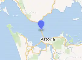
| |
Located fourteen miles (23 km) from the mouth of the river at the Pacific Ocean, the bridge is 4.067 miles (6.55 km) in length,[3] and was the final segment of U.S. Route 101 to be completed between Olympia, Washington, and Los Angeles, California.[4]
History

Ferry service between Astoria and the Washington side of the Columbia River began in 1926.[5] The Oregon Department of Transportation purchased the ferry service in 1946.[6] This ferry service did not operate during inclement weather and the half-hour travel time caused delays. In order to allow faster and more reliable crossings near the mouth of the river, a bridge was planned. The bridge was built jointly by the Oregon Department of Transportation and Washington State Department of Transportation.[7]
Construction on the structure began on November 5, 1962, and the concrete piers were cast at Tongue Point, four miles (6.5 km) upriver. The steel structure was built in segments at Vancouver, Washington, ninety miles (140 km) upriver, then barged downstream where hydraulic jacks lifted them into place.[8] The bridge opened to traffic on July 29, 1966, marking the completion of U.S. Route 101 and becoming the seventh major bridge built by Oregon in the 1950s–60s; ferry service ended the night before.[9] On August 27, 1966, Governors Mark Hatfield of Oregon and Dan Evans of Washington dedicated the bridge by cutting a ceremonial ribbon. The four-day ceremony was celebrated by 30,000 attendees who participated in parades, drives, and a marathon boat race from Portland to Astoria.[10] The cost of the project was $24 million, equivalent to $189 million today,[11] and was paid for by tolls that were removed on December 24, 1993, more than two years early.[3]
Details
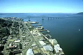
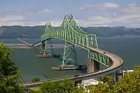
The bridge is 21,474 feet (4.0670 mi; 6.545 km) in length[12] and carries one lane of traffic in each direction. The cantilever-span section, which is closest to the Oregon side, is 2,468 feet (752 m) long,[12][13] and its main (central) span measures 1,233 feet (376 m).[1] It was built to withstand 150 mph (240 km/h) wind gusts and river water speeds of 9 mph (14 km/h).[4] As of 2004, an average of 7,100 vehicles per day use the Astoria–Megler Bridge.[14] Designed by William Adair Bugge (1900–1992), construction of the cantilever truss bridge was completed by the DeLong Corporation, the American Bridge Company, and Pomeroy Gerwick.[1]
The south end is located at 46.187°N 123.854°W beside what used to be the toll plaza, at the end of a 2,130-foot (650 m)[15] inclined ramp which goes through a full 360° loop while gaining elevation over land to provide almost 200 feet (61 m) of clearance over the shipping channel. The north end is at 46.241°N 123.875°W and connects directly to SR 401. Since most of the northern portion of the bridge is over shallow, non-navigable water, it is low to the water.
Repainting the bridge was planned for May 2009 through 2011 and budgeted at $20 million, to be shared by the states of Oregon and Washington.[16] A four-year planned paint stripping and repainting project was planned for March 2012 through December 2016.[17]
Pedestrians
Normally, only motor vehicles and bicycles are allowed on the bridge—not pedestrians.[18][19] There is no sidewalk and the shoulders are too narrow for pedestrians adjacent to 55 miles per hour (89 km/h) traffic. However, one day a year—usually in October—the bridge is host to the Great Columbia Crossing.[20][21] Participants are taken by shuttle to the Washington side, from where they run or walk to the Oregon side on a six miles (10 km) route across the bridge. Motor traffic is allowed to use only one lane (of two lanes) and is advised to expect delays during the two-hour event. For the first time, during the 2018 event, the Oregon Department of Transportation announced that the bridge would be closed to motor traffic.[22]
Popular culture
The bridge itself is featured prominently in the movies Short Circuit, Kindergarten Cop, Free Willy, Free Willy 2, and The Goonies. It stands in for the doomed fictional Madison Bridge in Irwin Allen's 1979 made-for-TV disaster movie The Night the Bridge Fell Down. Songwriter Sufjan Stevens most likely references the bridge in his song "Should Have Known Better" off his 2015 album Carrie & Lowell as a metaphor for dealing with his grief from the death of his mother.
Images
 View of the bridge from Astoria neighborhood.
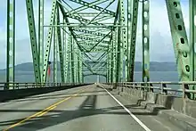 On the bridge, heading north.
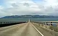 On the bridge, heading north.
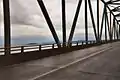 Astoria Bridge. Close up view of the through-truss section of the bridge.
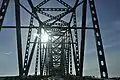 A close up view of the through-truss section of the bridge.
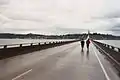 A view of the flat, continuous truss section of the bridge.
.jpg.webp) A workman's view from high on the bridge.
A workman's view from high on the bridge.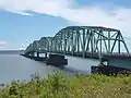 Washington end of the bridge.
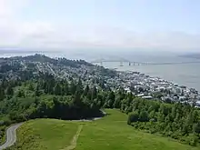 A view of the bridge from the Astoria Column.
 A cargo ship passing under the bridge.
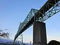 Looking up from beneath the bridge.
 Multiple cargo ships with the bridge in the background.
See also
 Transport portal
 Engineering portal
 Oregon portal
 United States portal
- List of bridges on U.S. Route 101 in Oregon
References
- Astoria Bridge. Structurae. Retrieved on July 5, 2015.
- "National Bridge Inventory Database". Retrieved July 5, 2015.
- "Lewis & Clark's Columbia River – 200 Years Later: Astoria–Megler Bridge". Retrieved January 25, 2013.
- Holstine, Craig E.; Hobbs, Richard (2005). Spanning Washington: Historic Highway Bridges of the Evergreen State. Washington State University Press. p. 100. ISBN 0-87422-281-8.
- Astoria–Megler Bridge. Archived June 11, 2008, at the Wayback Machine Astoria & Warrenton Area Chamber of Commerce. Retrieved on May 14, 2008.
- Vickers, Marques (2018). The Coastal River Bridges of Oregon. Marquis Publishing. p. 12.
- Smith, Dwight A.; Norman, James B.; Dykman, Pieter T. (1989). Historic Highway Bridges of Oregon. Oregon Historical Society Press. p. 299. ISBN 0-87595-205-4.
- "Last link". Lewiston Morning Tribune. (Idaho). (AP wirephoto). December 10, 1965. p. 1.
- "Astoria Bridge Over Columbia in Service". Statesman Journal. July 30, 1966. p. 3. Retrieved June 23, 2018 – via Newspapers.com.

- "Two Governors Officiate At Astoria Bridge Dedication". The Oregonian. August 28, 1966. p. 1.
- Federal Reserve Bank of Minneapolis. "Consumer Price Index (estimate) 1800–". Retrieved January 1, 2020.
- "Oregon Coastal Highway Bridges". Oregon Department of Transportation. Archived from the original on July 16, 2012. Retrieved July 5, 2015.
- "Big bridge ends high over water". Lewiston Morning Tribune. (Idaho). Associated Press (& photo). October 30, 1964. p. 16.
- NBI Structure Number: 07949C009 00241. Nationalbridges.com. Retrieved on May 14, 2008.
- "Google Maps route". Retrieved November 17, 2011.
- "Astoria–Megler Bridge Painting". Archived from the original on September 29, 2011. Retrieved November 17, 2011.
- "Astoria Megler Bridge Painting - Phase 2". Archived from the original on December 14, 2012. Retrieved November 17, 2011.
- Oregon Department of Transportation: Oregon Coast Bike Route Archived May 3, 2008, at the Wayback Machine
- "Cool Ship Watching Spots On the Lower Columbia". Archived from the original on December 23, 2007. Retrieved April 20, 2008.
- passport2oregon.com: Astoria
- http://www.greatcolumbiacrossing.com/
- Bridge closure for Great Columbia Crossing: Daily Astorian
External links
| Wikimedia Commons has media related to Astoria-Megler Bridge. |
- Historic American Engineering Record (HAER) No. OR-50, "Columbia River Gorge Bridge at Astoria, Spanning Columbia River at Oregon Coast Highway (U.S. Route 101), Astoria, Clatsop County, OR", 3 photos, 1 color transparency, 2 photo caption pages
- funbeach.com: Astoria–Megler Bridge
- oldoregon.com: Astoria–Megler Bridge
- Great Columbia Crossing
Crossings of the Columbia River | ||||
|---|---|---|---|---|
| ||||