Attavyros (municipality)
Attavyros (Greek: Αττάβυρος) is a former municipality on the island of Rhodes, in the Dodecanese, Greece. Since the 2011 local government reform it is part of the municipality Rhodes, of which it is a municipal unit.[2]
Attavyros
Αττάβυρος | |
|---|---|
 Attavyros Location within Rhodes 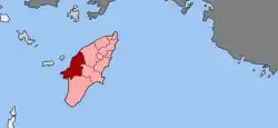 | |
| Coordinates: 36°14′N 27°51′E | |
| Country | Greece |
| Administrative region | South Aegean |
| Regional unit | Rhodes |
| Municipality | Rhodes |
| • Municipal unit | 234.4 km2 (90.5 sq mi) |
| Population (2011)[1] | |
| • Municipal unit | 2,433 |
| • Municipal unit density | 10/km2 (27/sq mi) |
| Time zone | UTC+2 (EET) |
| • Summer (DST) | UTC+3 (EEST) |
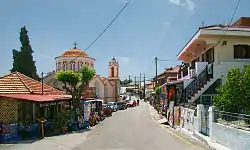
View of Siana
Geography
The population is 2,433 (2011 census); the land area is 234.350 km².[3] It is the westernmost municipal unit on the island, occupying the central portion of its western coast. The seat of the municipality was in Emponas (pop. 1,061). Its largest other towns are Ágios Isídoros (355) and Kritinia (454). In land area it is the second-largest municipal unit on Rhodes and the second-least densely populated, after South Rhodes (Notia Rodos).
The municipal unit is composed by five communities:
| Community | Population (2011) | Localities (main locality shown in italics) |
|---|---|---|
| Agios Isidoros (Άγιος Ισίδωρος) |
355 |
Agios Isidoros (355 inh.) |
| Emponas (Έμπωνας) |
1,242 |
Emponas (1,061 inh.) Mandriko (Μανδρικό, 181 inh.) |
| Kritinia (Κρητηνία) |
503 |
Kritinia (454 inh.) Kameiros Skala (Κάμειρος Σκάλα, 49 inh.) |
| Monolithos (Μονόλιθος) |
181 |
Monolithos (181 inh.) |
| Siana (Σιάνα) |
152 |
Siana (151 inh.) Lakki (Λακκί, 1 inh.) |
Gallery
 Aerial view of Attavyros mountain and municipal unit
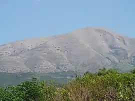 Attavyros mountain
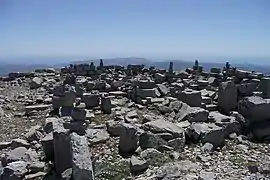 Temple of Zeus at the top of Attavyros Mountain
References
- "Απογραφή Πληθυσμού - Κατοικιών 2011. ΜΟΝΙΜΟΣ Πληθυσμός" (in Greek). Hellenic Statistical Authority.
- Kallikratis law Greece Ministry of Interior (in Greek)
- "Population & housing census 2001 (incl. area and average elevation)" (PDF) (in Greek). National Statistical Service of Greece. Archived from the original (PDF) on 2015-09-21.
External links
This article is issued from Wikipedia. The text is licensed under Creative Commons - Attribution - Sharealike. Additional terms may apply for the media files.