Atwood, Colorado
Atwood is an unincorporated town, a post office, and a census-designated place (CDP) located in and governed by Logan County, Colorado, United States. The CDP is a part of the Sterling, CO Micropolitan Statistical Area. The Atwood post office has the ZIP Code 80722.[3] At the United States Census 2010, the population of the Atwood CDP was 133, while the population of the 80722 ZIP Code Tabulation Area was 349 including adjacent areas.[4]
Atwood, Colorado | |
|---|---|
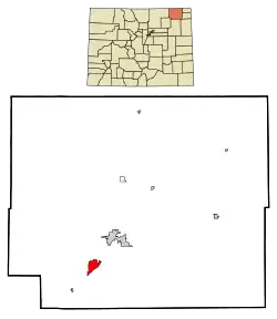 Location of the Atwood CDP in Logan County, Colorado. | |
 Atwood Location of the Atwood CDP in the United States. | |
| Coordinates: 40°33′02″N 103°16′29″W[1] | |
| Country | |
| State | |
| County | Logan County |
| Government | |
| • Type | unincorporated town |
| Area | |
| • Total | 1.034 sq mi (2.678 km2) |
| • Land | 1.034 sq mi (2.678 km2) |
| • Water | 0.000 sq mi (0.000 km2) |
| Elevation | 4,003 ft (1,220 m) |
| Population (2010) | |
| • Total | 133 |
| • Density | 129/sq mi (50/km2) |
| Time zone | UTC-7 (MST) |
| • Summer (DST) | UTC-6 (MDT) |
| ZIP Code[3] | 80722 |
| Area code(s) | 970 |
| GNIS feature[2] | Atwood CDP |
History
The Atwood post office has been in operation since 1885.[5] The community was named after John Atwood, a Unitarian minister.[6][7]
Geography
Atwood is located in southwestern Logan County. U.S. Route 6 passes through the community, leading northeast 7 miles (11 km) to Sterling, the county seat, and southwest 6 miles (10 km) to Merino. Colorado State Highway 63 leads south from Atwood 3 miles (5 km) to Exit 115 on Interstate 76 and 27 miles (43 km) to Akron.
The Atwood CDP has an area of 662 acres (2.678 km2), all land.[1]
Climate
This climate type occurs mostly on the outsides of the true deserts, in low-latitude semi-arid steppe regions. The Köppen Climate Classification subtype for this climate is "BSk". (Tropical and Subtropical Steppe Climate).[8]
| Climate data for Atwood, Colorado | |||||||||||||
|---|---|---|---|---|---|---|---|---|---|---|---|---|---|
| Month | Jan | Feb | Mar | Apr | May | Jun | Jul | Aug | Sep | Oct | Nov | Dec | Year |
| Average high °C (°F) | 4 (39) |
6 (43) |
11 (51) |
16 (60) |
21 (70) |
27 (81) |
31 (88) |
31 (87) |
26 (78) |
18 (65) |
10 (50) |
4 (40) |
17 (63) |
| Average low °C (°F) | −10 (14) |
−8 (17) |
−4 (24) |
1 (33) |
6 (43) |
11 (52) |
14 (58) |
14 (57) |
9 (48) |
2 (36) |
−4 (24) |
−9 (16) |
2 (35) |
| Average precipitation mm (inches) | 10 (0.4) |
13 (0.5) |
28 (1.1) |
51 (2) |
71 (2.8) |
66 (2.6) |
66 (2.6) |
53 (2.1) |
30 (1.2) |
25 (1) |
15 (0.6) |
13 (0.5) |
440 (17.4) |
| Source: Weatherbase[9] | |||||||||||||
Demographics
The United States Census Bureau initially defined the Atwood CDP for the United States Census 2000.
| Year | Pop. | ±% |
|---|---|---|
| 2000 | 195 | — |
| 2010 | 133 | −31.8% |
| 2020 | — | |
| Source: United States Census Bureau | ||
See also
- Outline of Colorado
- State of Colorado
- Colorado cities and towns
- Colorado counties
- Colorado metropolitan areas
References
- "State of Colorado Census Designated Places - BAS20 - Data as of January 1, 2020". United States Census Bureau. Retrieved December 23, 2020.
- "U.S. Board on Geographic Names: Domestic Names". United States Geological Survey. Retrieved December 23, 2020.
- "Look Up a ZIP Code". United States Postal Service. Retrieved December 23, 2020.
- "2010: DEC Summary File 1". United States Census Bureau. Retrieved December 23, 2020.
- "Post offices". Jim Forte Postal History. Archived from the original on 6 March 2016. Retrieved 22 June 2016.
- Exploring Colorado Highways: Trip Trivia. Exploring America's Highway. 2007. p. 109. ISBN 978-0-9777301-0-0.
- Dawson, John Frank (1954). Place names in Colorado: why 700 communities were so named, 150 of Spanish or Indian origin. Denver, CO: The J. Frank Dawson Publishing Co. p. 7.
- Climate Summary for Atwood, Colorado
- "Weatherbase.com". Weatherbase. 2013. Retrieved on May 8, 2013.
External links
Municipalities and communities of Logan County, Colorado, United States | ||
|---|---|---|
| City | 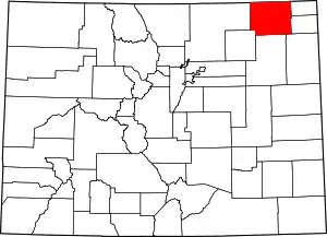 Map of Colorado highlighting Logan County | |
| Towns | ||
| CDPs | ||
| Unincorporated communities |
| |
| ||