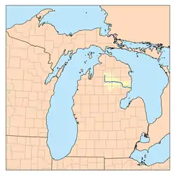
Au Sable River (Michigan)
The Au Sable River in Michigan, United States runs approximately 138 miles (222 km)[2] through the northern Lower Peninsula, through the towns of Grayling and Mio, and enters Lake Huron at the town of Oscoda. It is considered one of the best brown trout fisheries east of the Rockies[3] and has been designated a blue ribbon trout stream by the Michigan Department of Natural Resources.[4] French Rivière au sable means "Sand River." A 1795 map calls it the Beauais River.
| Au Sable River | |
|---|---|
 Map of the Au Sable River | |
| Location | |
| Country | United States |
| Physical characteristics | |
| Source | |
| • location | Frederic Township, Crawford County, Michigan |
| Mouth | |
• location | Lake Huron at Au Sable, Michigan |
• elevation | 581 ft (177 m)[1] |
| Length | 138 miles (222 km) |
| Type | Scenic |
| Designated | October 4, 1984 |
.jpg.webp)
Description
The Au Sable has a drainage basin of 1,932 square miles (5,000 km2)[5] and an average flow of 1,100 ft3/s (31 m3/s) at its mouth.[6] The river drops 650 feet (200 m) from its source at the junction of Kolka and Bradford Creeks.[6]
The main stream of the river is formed at 44°48′21″N 84°45′29″W[1] in Frederic Township in Crawford County by the confluence of Kolke[7] and Bradford Creeks,[8] which both rise in Otsego County. The river flows south then turns east through Grayling, where it is joined by the East Branch Au Sable River at 44°39′55″N 84°42′13″W. The East Branch rises in Lovells Township, Crawford County at 44°49′46″N 84°35′59″W.[9]
The Au Sable continues eastward and is joined by the South Branch Au Sable River at 44°39′23″N 84°28′06″W in South Branch Township. The South Branch rises out of Lake St. Helen in Richfield Township, Roscommon County at 44°22′54″N 84°26′38″W[10] and flows northwest into Roscommon then northeast to the main branch of the Au Sable. The North Branch Au Sable River joins within approximately 5 miles (8.0 km) in eastern Crawford County at 44°40′14″N 84°22′51″W near the boundary with Oscoda County. The North Branch rises in Bagley Township, Otsego County, near Lake Otsego.[11]
The Au Sable then flows mostly east through Oscoda County, then south and east through Alcona County and Iosco County. The river's watershed also drains portions of Montmorency County and Ogemaw County.
Most of the main branch of the Au Sable flows through or adjacent to the Huron-Manistee National Forest. 23 miles (37 km) of the river, from the Mio Pond downstream to the Alcona Pond, was designated as a National Wild and Scenic River on October 4, 1984. The watershed provides habitat for bald eagles and the endangered Kirtland's warbler. Five percent of the land in the watershed is National Forest and 29% is state forest.
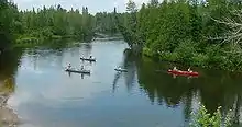
It is a designated trout stream, and many canoe liveries exist along the river, which offer canoe trips from a few hours to as long as a week. The river was originally a grayling fishery with brook trout being released in the 1880s. By 1908 the grayling were gone although they were reintroduced in 1987. (See Grayling, Michigan for more information on the Grayling and the fish hatchery.) Brown trout is the current main catch. The Lumberman's Monument, in honor of the lumberjacks that first populated the area, is located on the river about 15 miles (24 km) west of Oscoda. Lumbering along the river began in the 1860s and was finished by the 1910s.
The Au Sable River is also the site of a yearly 120-mile (190 km) pro-am canoe race, the Au Sable River Canoe Marathon, which begins at 9:00 p.m. and runs through the night into the next day. Winning times have ranged from 14 to 21 hours. The race was first run in 1947.
River Road, running parallel with the Au Sable River, is a designated National Scenic Byway.
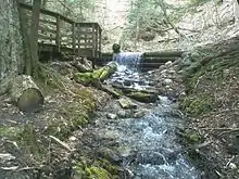
There are six hydro-electric power plants in the Au Sable River basin, with a total installed capacity of 41 MW and an average annual energy output of 500 GJ. The six reservoirs were constructed between 1911 and 1924.
The Au Sable has about 350 miles (560 km) of tributary streams including the Pine River.
Towns along river
River dams
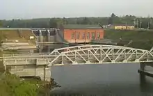
Ordered from upriver to downriver, all belonging to the power company Consumers Energy:
Historical markers
.jpg.webp)
The river has five historical markers on it:
- Cooke Hydroelectric Plant
- Five Channels Dam Workers Camp
- The Louis Chevalier Claim
- Mio Hydroelectric Plant[13]
- Chief Shoppenagon
River valley attractions and events
- The Michigan AuSable Valley Railroad is located in Fairview. It is a 1/4 scale, 16 in (406 mm) gauge ridable miniature railway, which offers rides on a passenger train through the scenic Northern Michigan landscape. It operates in jack pine country during the summer months. Riders travel through parts of the Huron National Forest and overlook the beautiful Comins Creek Valley.[14]
- Au Sable River Canoe Marathon, starts in Grayling and ends in Oscoda 120 miles (190 km) down the river. It is one of three marathon races that constitute canoe racing's Triple Crown. The race is always held the last full weekend in July.[15]
- First Dam Canoe Race (MCRA - Canoe Race) is a yearly event.[16]
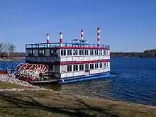
- Six miles west of Oscoda, on River Road Scenic Byway, the Au Sable River Queen offers paddle boat excursions.[17]
- Within this area is Kirtland's warbler habitat, so it is an important center for bird watchers.
- The Lumberman's Monument is adjacent to the river.
- River Road, running parallel with the river, is a designated National Scenic Byway for the 23 miles that go into Oscoda.[18]
- Canoer's Memorial
- Iargo Springs
See also
- Ausable River (Lake Huron), an Ontario tributary of Lake Huron
Notes
- "Au Sable River". Geographic Names Information System. United States Geological Survey.
- U.S. Geological Survey. National Hydrography Dataset high-resolution flowline data. The National Map Archived 2012-03-29 at the Wayback Machine, accessed November 7, 2011
- Card, James (January 24, 2017). "In Michigan, a Fight Over the Future of a Fabled Trout River". The New York Times. Retrieved January 28, 2017.
- "Blue Ribbon Trout Streams".
- Au Sable River, Michigan Department of Natural Resources
- Au Sable River Natural River Plan, Fisheries Division, Michigan Department of Natural Resources
- U.S. Geological Survey Geographic Names Information System: Kolke Creek
- "Bradford Creek". Geographic Names Information System. United States Geological Survey.
- "East Branch Au Sable River". Geographic Names Information System. United States Geological Survey.
- "South Branch Au Sable River". Geographic Names Information System. United States Geological Survey.
- "North Branch Au Sable River". Geographic Names Information System. United States Geological Survey.
- "AuSable River Tour". Archived from the original on 2013-10-22. Retrieved 2011-08-09.
- "Mio electric Plant historical marker". Archived from the original on 2014-07-17. Retrieved 2008-01-13.
- "MAVRR". mavrailroad.com.
- "AuSable River Canoe Marathon | World's Toughest Spectator Race".
- "Mio Race Info". www.miracing.com.
- "Au Sable River Queen". Archived from the original on 2008-05-14. Retrieved 2008-01-13.
- "River Road Scenic Byway at America's Byways". Archived from the original on 2007-02-03. Retrieved 2007-12-06.
External links
| Wikimedia Commons has media related to Au Sable River (Michigan). |
- Map of Au Sable River watershed
- Anglers of the Au Sable
- Au Sable Canoe Marathon
- Huron-Manistee National Forest
- Lumberman's Monument
- Lumberman's Monument at the U.S. Forest Service
- River Road Scenic Byway at America's Byways.
| Authority control |
|
|---|