Roscommon County, Michigan
Roscommon County is a county located in the U.S. state of Michigan. As of the 2010 census, the population was 24,449.[2] The county seat is Roscommon.[3] The county was founded in 1840 and organized in 1875.[1]
Roscommon County | |
|---|---|
.jpg.webp) Roscommon County Building in Roscommon | |
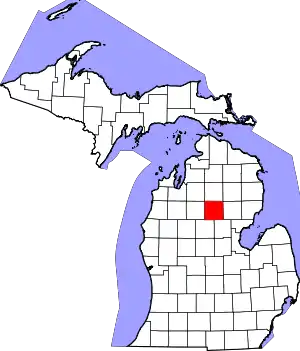 Location within the U.S. state of Michigan | |
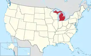 Michigan's location within the U.S. | |
| Coordinates: 44°20′N 84°37′W | |
| Country | |
| State | |
| Founded | 1840 (created) 1875 (organized)[1] |
| Named for | County Roscommon, Ireland |
| Seat | Roscommon |
| Largest settlement | Houghton Lake Roscommon (incorporated) |
| Area | |
| • Total | 580 sq mi (1,500 km2) |
| • Land | 520 sq mi (1,300 km2) |
| • Water | 60 sq mi (200 km2) 10%% |
| Population | |
| • Estimate (2018) | 23,884 |
| • Density | 47/sq mi (18/km2) |
| Time zone | UTC−5 (Eastern) |
| • Summer (DST) | UTC−4 (EDT) |
| Congressional district | 4th |
History
The county was formed by the Michigan Legislature in 1840 as Mikenauk County, then renamed Roscommon County in 1843. It was administered by Michilimackinac (Mackinac), Cheboygan, and Midland counties, in succession, prior to the organization of county government in 1875.[4] Roscommon County was named after County Roscommon, Ireland.[1][5]
There are three official Michigan historical markers in the county:[6]
- Gerrish
- Pioneer House
- Terney House[7]
Geography
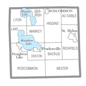
According to the US Census Bureau, the county has a total area of 580 square miles (1,500 km2), of which 520 square miles (1,300 km2) is land and 60 square miles (160 km2) (10%) is water.[8] Roscommon County is considered to be part of Northern Michigan. Part of Michigan's Au Sable State Forest falls within the county. The US Forest Service's Roscoe Fire Management Unit includes Ogemaw and Roscommon Counties.
Geographic features
During prehistoric times, glacial action helped shape the Michigan-area terrain. A large portion of the area is the Grayling outwash plain, which includes sandy ice-disintegration ridges; jack pine barrens, white pine-red pine forest, and northern hardwood forest. Large lakes were created by glacial action.[9]
Prominent geographic features include:
- Au Sable River
- Backus Creek
- Cut River
- Dead Stream Flooding
- Higgins Lake
- Houghton Lake
- Houghton Lake Flats
- Lake St. Helen
- Marl Lake
- Roscommon Virgin Pine Stand – a 160-acre (650,000 m2) parcel within the Au Sable State Forest, 8 miles (13 km) north of St. Helen, Michigan, and 8 miles east of Roscommon. An old-growth stand of red pine, which includes a former national champion red pine.[10]
- Underground oil deposits
Major highways
 I-73 (future)
 I-75 – runs south, SE, and east through the NE middle portion of county.
 US 127 – runs north–south through west portion of county. Passes on west side of Higgins and Houghton Lakes.
 M-18 – runs north–south through center of county. Passes Roscommon and Prudenville. Leaving Roscommon, runs east along north line of county for 5.6 miles (9 km) before turning to NE.
 M-55 – runs east–west through center of county to intersection with I75, 7 miles (11 km) west of east line of county.
 M-157 – short (1.1 mile/1.8 km) north-south spur connecting M18 to M55, east of Houghton Lake.
 F-18 – runs south from Prudenville. Exits the county on the line between Clare and Gladwin counties.[11]
Airports
- Houghton Lake State Airport is located in Roscommon Township.
- Roscommon County–Blodgett Memorial Airport is located in Markey Township.
Adjacent counties
- Crawford County – north
- Oscoda County – northeast
- Ogemaw County – east
- Gladwin County – southeast
- Clare County – southwest
- Missaukee County – west
- Kalkaska County – northwest
Demographics
| Historical population | |||
|---|---|---|---|
| Census | Pop. | %± | |
| 1880 | 1,459 | — | |
| 1890 | 2,033 | 39.3% | |
| 1900 | 1,787 | −12.1% | |
| 1910 | 2,274 | 27.3% | |
| 1920 | 2,032 | −10.6% | |
| 1930 | 2,055 | 1.1% | |
| 1940 | 3,668 | 78.5% | |
| 1950 | 5,916 | 61.3% | |
| 1960 | 7,200 | 21.7% | |
| 1970 | 9,892 | 37.4% | |
| 1980 | 16,374 | 65.5% | |
| 1990 | 19,776 | 20.8% | |
| 2000 | 25,469 | 28.8% | |
| 2010 | 24,449 | −4.0% | |
| 2018 (est.) | 23,884 | [12] | −2.3% |
| US Decennial Census[13] 1790-1960[14] 1900-1990[15] 1990-2000[16] 2010-2018[2] | |||
As of the 2000 United States Census,[17] there were 25,469 people, 11,250 households, and 7,616 families residing in the county. The population density was 49 people per square mile (19/km2). There were 23,109 housing units at an average density of 44 per square mile (17/km2). The racial makeup of the county was 97.99% White, 0.32% Black or African American, 0.64% Native American, 0.19% Asian, 0.04% Pacific Islander, 0.10% from other races, and 0.72% from two or more races. 0.80% of the population were Hispanic or Latino of any race. 24.4% were of German, 12.7% English, 9.9% Irish, 9.2% Polish, 9.2% American and 6.7% French ancestry. 97.2% spoke English as their first language. Those citing "American" ancestry in Roscommon County are of overwhelmingly English extraction, however most English Americans identify simply as having American ancestry because their roots have been in North America for so long, in some cases since the 1600s.[18][19][20][21][22]
There were 11,250 households, out of which 21.90% had children under the age of 18 living with them, 56.70% were married couples living together, 7.70% had a female householder with no husband present, and 32.30% were non-families. 28.10% of all households were made up of individuals, and 14.00% had someone living alone who was 65 years of age or older. The average household size was 2.23 and the average family size was 2.69.
The county population contained 20.00% under the age of 18, 5.50% from 18 to 24, 21.40% from 25 to 44, 29.30% from 45 to 64, and 23.80% who were 65 years of age or older. The median age was 47 years. For every 100 females there were 96.90 males. For every 100 females age 18 and over, there were 94.30 males.
The median income for a household in the county was $30,029, and the median income for a family was $35,757. Males had a median income of $31,878 versus $20,549 for females. The per capita income for the county was $17,837. About 8.60% of families and 12.40% of the population were below the poverty line, including 18.90% of those under age 18 and 6.50% of those age 65 or over.
Religion
- Roscommon County is part of the Roman Catholic Diocese of Gaylord.[23]
- The Church of Jesus Christ of Latter-day Saints has one meetinghouse in the county, in Houghton Lake.[24]
Government
Roscommon County voters tend to vote Republican; they have selected the Republican Party nominee in 74% of national elections (25 of 34).
| Year | Republican | Democratic | Third Parties |
|---|---|---|---|
| 2020 | 64.3% 9,670 | 34.4% 5,166 | 1.3% 198 |
| 2016 | 62.2% 8,141 | 32.7% 4,287 | 5.1% 668 |
| 2012 | 51.2% 6,701 | 47.4% 6,198 | 1.4% 178 |
| 2008 | 47.7% 6,727 | 50.2% 7,082 | 2.0% 287 |
| 2004 | 51.3% 7,364 | 47.4% 6,810 | 1.3% 185 |
| 2000 | 47.9% 6,190 | 49.8% 6,433 | 2.4% 305 |
| 1996 | 34.9% 4,135 | 51.5% 6,092 | 13.6% 1,607 |
| 1992 | 34.7% 4,170 | 43.7% 5,243 | 21.6% 2,594 |
| 1988 | 56.9% 5,866 | 42.7% 4,394 | 0.4% 43 |
| 1984 | 65.4% 6,419 | 34.2% 3,359 | 0.5% 45 |
| 1980 | 54.7% 5,280 | 39.0% 3,763 | 6.4% 616 |
| 1976 | 54.9% 4,608 | 43.9% 3,691 | 1.2% 102 |
| 1972 | 64.2% 4,136 | 33.9% 2,187 | 1.9% 122 |
| 1968 | 55.9% 2,635 | 34.8% 1,639 | 9.3% 439 |
| 1964 | 42.3% 1,722 | 57.6% 2,345 | 0.2% 7 |
| 1960 | 68.9% 2,731 | 30.9% 1,226 | 0.1% 5 |
| 1956 | 76.2% 2,674 | 23.6% 827 | 0.2% 8 |
| 1952 | 78.6% 2,547 | 20.9% 676 | 0.5% 16 |
| 1948 | 73.9% 2,055 | 24.7% 687 | 1.4% 39 |
| 1944 | 72.2% 1,292 | 27.1% 484 | 0.7% 13 |
| 1940 | 64.2% 1,360 | 34.9% 739 | 0.9% 19 |
| 1936 | 49.6% 836 | 46.4% 782 | 3.9% 66 |
| 1932 | 42.6% 601 | 53.7% 757 | 3.7% 52 |
| 1928 | 76.3% 780 | 23.1% 236 | 0.7% 7 |
| 1924 | 69.6% 484 | 14.2% 99 | 16.1% 112 |
| 1920 | 75.3% 652 | 21.0% 182 | 3.7% 32 |
| 1916 | 53.4% 311 | 41.1% 239 | 5.5% 32 |
| 1912 | 22.6% 134 | 25.3% 150 | 52.1% 309 |
| 1908 | 69.4% 427 | 23.9% 147 | 6.7% 41 |
| 1904 | 71.5% 373 | 22.2% 116 | 6.3% 33 |
| 1900 | 64.5% 327 | 34.5% 175 | 1.0% 5 |
| 1896 | 65.4% 282 | 32.7% 141 | 1.9% 8 |
| 1892 | 44.3% 239 | 53.0% 286 | 2.8% 15 |
| 1888 | 50.0% 360 | 49.7% 358 | 0.3% 2 |
| 1884 | 48.8% 427 | 49.7% 435 | 1.5% 13 |
The county government operates the jail, maintains rural roads, operates the major local courts, records deeds, mortgages, and vital records, administers public health regulations, and participates with the state in the provision of social services. The county board of commissioners controls the budget and has limited authority to make laws or ordinances. In Michigan, most local government functions — police and fire, building and zoning, tax assessment, street maintenance, etc. — are the responsibility of individual cities and townships.
Elected officials
- Prosecuting Attorney: Mary Beebe
- Sheriff: Ed Stern
- County Clerk/Register of Deeds: Michelle Stevenson
- County Treasurer: Rebecca A. Ragan
- Drain Commissioner: Rex Wolfsen
(information as of January 2021)
Attractions and events
The community is centered in the area of two very large lakes, in the middle of large state forests. Wildlife are nearby, including bear, deer, eagles, Kirtland's warblers, and turkeys. Local attractions and activities include:
- Birding
- Bluegill Festival each summer in St. Helen
- Boating, paddling (canoe and kayak)
- Firemen's Memorial Festival, an annual event (September) since 1979.[26]
- Fishing
- Golf
- Hiking
- Hunting
- Kirtland Warbler Habitat and Festival is an annual (held in May) event hosted by Kirtland Community College.[27]
- Michigan Shore-to-Shore Trail, a 500-mile (800 km) system of interconnected trails, passes through the area. It runs from Empire to Oscoda, and points beyond.[28]
- Nordic skiing
- ORV and groomed snowmobile trails
- Sailing
- Tip-up-town winter festival, Houghton Lake, an annual event (held in January).[29]
Education
Some popular schools in Roscommon County is the Charlton Heston Academy, Roscommon Area School District, Houghton Lake Community Schools, and Kirtland Community College.[30]
Communities
Village
- Roscommon (county seat)
Civil townships
Census-designated places
Other unincorporated communities
See also
References
- "Bibliography on Roscommon County". Clarke Historical Library, Central Michigan University. Retrieved January 29, 2013.
- "State & County QuickFacts". US Census Bureau. Retrieved August 29, 2013.
- "Find a County". National Association of Counties. Retrieved June 7, 2011.
- Newberry Library. "Michigan: Individual County Chronologies". Atlas of County Historical Boundaries. Retrieved November 4, 2016.
- Michigan History, Arts and Libraries on sources of County names.
- "Michigan Historical Markers". michmarkers.com.
- "Terney House".
- "2010 Census GazetteerFiles". US Census Bureau. August 22, 2012. Archived from the original on November 13, 2013. Retrieved September 28, 2014.
- "Archived copy". Archived from the original on June 25, 2013. Retrieved December 12, 2014.CS1 maint: archived copy as title (link) Michigan regional geology
- "Roscommon Red Pines". Michigan Department of Natural Resources. Retrieved December 26, 2012.
- Roscommon County MI Google Maps (accessed 6 September 2018)
- "Population and Housing Unit Estimates". Retrieved May 17, 2019.
- "US Decennial Census". US Census Bureau. Retrieved September 28, 2014.
- "Historical Census Browser". University of Virginia Library. Retrieved September 28, 2014.
- "Population of Counties by Decennial Census: 1900 to 1990". US Census Bureau. Retrieved September 28, 2014.
- "Census 2000 PHC-T-4. Ranking Tables for Counties: 1990 and 2000" (PDF). US Census Bureau. Retrieved September 28, 2014.
- "U.S. Census website". US Census Bureau. Retrieved January 31, 2008.
- "Ancestry of the Population by State: 1980 - Table 3" (PDF). Retrieved February 10, 2012.
- Sharing the Dream: White Males in a Multicultural America By Dominic J. Pulera.
- Reynolds Farley, 'The New Census Question about Ancestry: What Did It Tell Us?', Demography, Vol. 28, No. 3 (August 1991), pp. 414, 421.
- Stanley Lieberson and Lawrence Santi, 'The Use of Nativity Data to Estimate Ethnic Characteristics and Patterns', Social Science Research, Vol. 14, No. 1 (1985), pp. 44-6.
- Stanley Lieberson and Mary C. Waters, 'Ethnic Groups in Flux: The Changing Ethnic Responses of American Whites', Annals of the American Academy of Political and Social Science, Vol. 487, No. 79 (September 1986), pp. 82-86.
- "The Diocese of Gaylord, Michigan : A Diocese of the Roman Catholic Church - Diocese of Gaylord".
- Worship With Us: Church Locator ComeUntoChrist.org (accessed 6 September 2018)
- US Election Atlas
- Firemen's Memorial Festival
- "Kirtland". kirtland.edu. May 13, 2014. Archived from the original on January 2, 2008.
- Michigan Shore to Shore Riding and Hiking Trail.
- Tip-up-town. Archived December 7, 2006, at the Wayback Machine
- Schools Roscommon County website
External links
| Wikimedia Commons has media related to Roscommon County, Michigan. |
- Roscommon County
- Higgins Lake/Roscommon Chamber of Commerce
- Houghton Lake/Roscommon Chamber of Commerce
- "Bibliography on Roscommon County". Clarke Historical Library, Central Michigan University.
- A history of northern Michigan and its people Powers, Perry Francis. Chicago: Lewis Publishing Co., 1912. pp. 554–5
- History of Michigan. Moore, Charles. Chicago: Lewis Publishing Co., 1915. p. 709
Places adjacent to Roscommon County, Michigan | ||||||||||
|---|---|---|---|---|---|---|---|---|---|---|
| ||||||||||
Municipalities and communities of Roscommon County, Michigan, United States | ||
|---|---|---|
| Village | Map of Michigan highlighting Roscommon County | |
| Civil townships | ||
| CDPs | ||
| Other unincorporated communities | ||
| ||
| Central cities | |
|---|---|
| Counties | |
| Geography | |
| Transportation | |
| Economy | |
| Authority control |
|---|