Aughinish, County Clare
Aughinish (sometimes written as Aughnish) (Eachinis in Irish) is a small island and townland located in Oughtmama Parish of the Barony of Burren in north County Clare, in Ireland on the south shore of Galway Bay.[1] By road it is 10.9 kilometres (6.8 mi) northwest of Kinvarra.[2] The island is approximately two miles (3 km) wide and a mile (1.6 km) from the northernmost tip to the southernmost point and has approximately fifty inhabitants.
Aughinish
Eachinis | |
|---|---|
Island and village | |
 | |
 Aughinish Location in Ireland | |
| Coordinates: 53°09′47″N 9°04′18″W | |
| Country | Ireland |
| County | County Clare |
| Elevation | 0 m (0 ft) |
| Time zone | UTC+0 (WET) |
| • Summer (DST) | UTC-1 (IST (WEST)) |
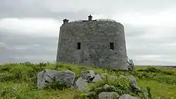
The island was originally connected to County Clare, but in 1755 that connection was lost due to the tsunami effect of the massive Portuguese earthquake.[3] The British built the existing 0.5 miles (0.80 km)[4] causeway to County Galway to service their troops in the Martello Tower constructed on the island after 1811.[5] So to this day, land access to Aughinish, County Clare is still only through County Galway.
References
- "Clare Library: Map of Oughtmama Parish showing Townlands". Clare Library. Retrieved 7 January 2014.
- Google (9 February 2014). "Aughinish, County Clare" (Map). Google Maps. Google. Retrieved 9 February 2014.
- Extreme wave events in Ireland: 14 680 BP–2012 p. 634
- Spellissy, Sean (1 January 1999). The History of Galway. Celtic Bookshop. ISBN 978-0-9534683-3-1.
- Sheerin, Norbert (2000). Renmore and Its Environs: An Historical Perspective. Renmore Residents Association. p. 14. ISBN 978-0-9538591-0-8.
External links
Further reading
- Glynn, Rose: The Story of Aughinish, 2002. (self-published)
Places in County Clare | ||
|---|---|---|
| Towns | 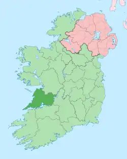 | |
| Villages |
| |
| Regions | ||
| Islands | ||
| ||