Ay (river)
The Ay (Bashkir: Әй, Russian: Ай) is a river in Bashkortostan and Chelyabinsk Oblast in Russia, a left tributary of the Ufa. The river is 549 kilometres (341 mi) long, and its drainage basin covers 15,000 square kilometres (5,800 sq mi).[1] The Ay freezes up in late October or early November and remains icebound until mid-April. The cities of Zlatoust and Kusa are along the river Ay. Along the banks of the river, there are many steep cliff sides and caves.[2] The current of the river has been used for hydroelectric power. It is also possible to fish for pike, bleak, and carp, to name a few species.[3]
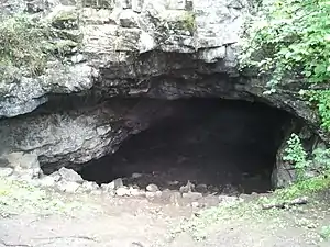
Kurgazak cave off the coast of the river Ay
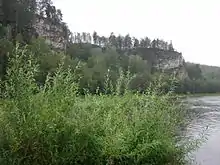
Rocky ledge near the river Ay
| Ay | |
|---|---|
 View from the bank of the river | |
| Etymology | "month" or "moon" in Bashkir language |
| Native name | Әй (Bashkir) |
| Location | |
| Country | Russia |
| Oblasts | Chelyabinsk Oblast, Republic of Bashkortostan |
| Cities | Zlatoust, Kusa |
| Physical characteristics | |
| Source | |
| • location | Uraltau range |
| Mouth | Ufa |
• coordinates | 54°39′11″N 59°06′41″E |
• elevation | 525 ft |
| Length | 549 km (341 mi) |
| Basin size | 15,000 km2 (5,800 sq mi) |
| Basin features | |
| Progression | Ufa→ Belaya→ Kama→ Volga→ Caspian Sea |
References
- «Река АЙ», Russian State Water Registry
- "Река Ай — Наш Урал". Наш Урал (in Russian). 2016-01-09. Retrieved 2018-02-22.
- "Ай, река - КАРТА74.РФ". www.xn--74-6kca2cwbo.xn--p1ai. Retrieved 2018-02-22.
This article includes content derived from the Great Soviet Encyclopedia, 1969–1978, which is partially in the public domain.
This article is issued from Wikipedia. The text is licensed under Creative Commons - Attribution - Sharealike. Additional terms may apply for the media files.