Bátorliget
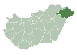
Bátorliget (before 1975: Aporliget)[1] is a village in Szabolcs-Szatmár-Bereg county, in the Northern Great Plain region of eastern Hungary.
Bátorliget | |
|---|---|
 Coat of arms | |
 Bátorliget Bátorliget | |
| Coordinates: 47°45′45″N 22°16′21″E | |
| Country | |
| County | Szabolcs-Szatmár-Bereg |
| Area | |
| • Total | 33.30 km2 (12.86 sq mi) |
| Population (2015) | |
| • Total | 669 |
| • Density | 20/km2 (52/sq mi) |
| Time zone | UTC+1 (CET) |
| • Summer (DST) | UTC+2 (CEST) |
| Postal code | 4343 |
| Area code(s) | 42 |
Geography
It covers an area of 33.30 km2 (13 sq mi) and has a population of 669 people (2015).
Nearby is Bátorliget Pasture NCA (Nature Conservation Area).[2]
References
- Bátorliget (in Hungarian)
- "Bátorliget Pasture NCA". hnp.hu. Retrieved 26 August 2015.
| Authority control |
|
|---|
This article is issued from Wikipedia. The text is licensed under Creative Commons - Attribution - Sharealike. Additional terms may apply for the media files.