Březová nad Svitavou
Březová nad Svitavou (until 1949 Březová; German: Brüsau)[2] is a small town in Svitavy District in the Pardubice Region of the Czech Republic. It has about 1,600 inhabitants. It is on the stretch of the Svitava river which historically marked the border between Bohemia and Moravia.
Březová nad Svitavou | |
|---|---|
Town | |
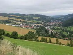 General view of the town | |
 Flag  Coat of arms | |
 Březová nad Svitavou Location in the Czech Republic | |
| Coordinates: 49°39′8″N 16°30′51″E | |
| Country | |
| Region | Pardubice |
| District | Svitavy |
| First mentioned | 1295 |
| Government | |
| • Mayor | Karel Adámek |
| Area | |
| • Total | 12.70 km2 (4.90 sq mi) |
| Elevation | 383 m (1,257 ft) |
| Population (2020-01-01[1]) | |
| • Total | 1,644 |
| • Density | 130/km2 (340/sq mi) |
| Time zone | UTC+1 (CET) |
| • Summer (DST) | UTC+2 (CEST) |
| Postal code | 569 02 |
| Website | www |
Notable people
- Karl Kořistka (1825–1906), geographer, cartographer and mathematician
References
- "Population of Municipalities – 1 January 2020". Czech Statistical Office. 2020-04-30.
- "Brüsau bei Zwittau (German)". zwittau.de.
External links
 Media related to Březová nad Svitavou at Wikimedia Commons
- Official website
| Authority control |
|
|---|
This article is issued from Wikipedia. The text is licensed under Creative Commons - Attribution - Sharealike. Additional terms may apply for the media files.