B1354 road
The B1354 is a secondary road in England. It runs east–west for about 8.2 miles (13.2 km)[1] between the A148 at Thursford[2] and the B1149 at Saxthorpe,[3] and is entirely within the county of Norfolk.[4] The road is the main route of access to Norwich and to Fakenham for the large villages of Melton Constable and Briston. Another section of road, with the same number, about 10 km long and also running east–west, runs from the A140 in Hainford via Coltishall to Hoveton ending at a junction with the A1151 and the A1062.
| B1354 | |
|---|---|
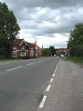 Approaching Melton Constable on B1354 Briston Road. | |
| Route information | |
| Length | 8.2 mi (13.2 km) |
| Major junctions | |
| West-north-west end | A148 Thursford |
| A148 B1110 B1149 | |
| East-south-east end | B1149 Saxthorpe |
| Road network | |
Thursford to Corpusty and Saxthorpe
The route of this old thoroughfare can be clearly made out on William Faden's map of Norfolk[5] which was surveyed between 1790 and 1794. This map, the first large-scale map (at one inch to the mile) of the whole county, is a record of the landscape and transport system of the county of Norfolk in the late 18th century, and shows that despite the Parliamentary Enclosure of the early 19th century the route has changed very little. Much of the route on the map is highlighted in a pale pink which marks it out as an important artery of the time. In the late 20th century the route has been redirected from its junction with the A148 at Thursford for a distance of 1.7 miles (2.7 km) and now takes the route of a new road constructed on the old track bed of the Midland and Great Northern Joint Railway[6] route between Melton Constable and Fakenham.
Hainford to Hoveton
A second section of the route exists, running from near the village of Hainford, at a junction with the A140. The road continues through the Waterloo area of Hainford before reaching the Buxton-Horstead road and then a mini roundabout in the village of Horstead. Here the road multiplexes with the B1150, passes over the Coltishall Bridge into the village of Coltishall. The road leaves the B1150 at 'Coltishall Island' (where there is a petrol station) before continuing past Coltishall Common into the village of Belaugh before reaching the large commercial village of Hoveton where the road ends at the A1151.
Points of interest
At the point on the route were the road leaves the old track bed and returns to its original course the road passes the old Gunthorpe level crossing gatehouse and signal box on the Midland and Great Northern Joint Railway, which has been restored to its former glory and is now a tea room.
Heading from the West-north-west end, 3 miles (4.8 km) on the road reaches Melton Constable and on the south side of the road there is an industrial area that was once the site of the busy junction of four railway lines. The lines which came from Cromer, North Walsham, King's Lynn and Norwich and linked Norfolk to the Midlands. There was once a station with a platform 800 feet (240 m) long and Midland and Great Northern Joint Railway's main workshops and factory were also situated here. This made this road a busy and important part of Norfolk's transport infrastructure.
Declassified section
The middle section of the B1354 was declassified in the 2000s, hence the route now being in two separate sections. The route continued after Saxthorpe through Blickling, the town of Aylsham and Buxton, to reach Horstead. As part of the declassification of this section, the road that connects the A140 with Horstead via Waterloo was newly classified as the B1354.[7]
Gallery
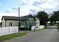 The gatehouse and Signal box with the B1345 passing beyond
Destinations
Travelling from West-north-west East-south-east the road passes through :
References
- Calculation Gathered using Google Pedometer
- OS Explorer Map 24 - Norfolk Coast Central. ISBN 0-319-21726-4.
- OS Explorer Map 252 - Norfolk Coast East. ISBN 978-0-319-23815-8.
- County A to Z Atlas, Street & Road maps Norfolk, ISBN 978-1-84348-614-5
- Faden’s Map of Norfolk 1797, Digitally redrawn in 2005 by Andrew Macnair. North Central Map ISBN 978-0-9550398-2-9
- Bartholomew's Gazetteer of the British Isles, 1914 edition
- SABRE