Bad Essen
Bad Essen is a small municipality and health resort in the district of Osnabrück, in Lower Saxony. Bad Essen with its historical centre is located on the German Timber-Frame Road.
Bad Essen | |
|---|---|
 Bad Essen | |
 Coat of arms | |
Location of Bad Essen within Osnabrück district 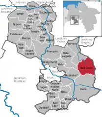 | |
 Bad Essen 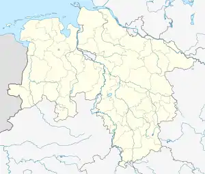 Bad Essen | |
| Coordinates: 52°19′17″N 8°20′24″E | |
| Country | Germany |
| State | Lower Saxony |
| District | Osnabrück |
| Government | |
| • Mayor | Timo Natemeyer (Ind.) |
| Area | |
| • Total | 103.31 km2 (39.89 sq mi) |
| Elevation | 113 m (371 ft) |
| Population (2019-12-31)[1] | |
| • Total | 15,738 |
| • Density | 150/km2 (390/sq mi) |
| Time zone | UTC+01:00 (CET) |
| • Summer (DST) | UTC+02:00 (CEST) |
| Postal codes | 49152 |
| Dialling codes | 05472 |
| Vehicle registration | OS |
| Website | www.badessen.de |

Bad Essen, church: die Sankt Nikolauskirche
Geography
The town of Bad Essen is on the North German Plains, because of the transition of the low mountain range to the plains. The Wiehengebirge Range covers approximately the southern third of the town and reaches an altitude of 211m above sea level. The highest point of the Wiehengebirge Range is on the black Brink in Lintorf. The northern part of the town is flat, with an average altitude of 50m above sea level. The Hunte flows through the eastern part of Bad Essen northwards and crosses the Midland Canal in Wittlage.
External links
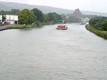
Midland Canal in Bad Essen
| Authority control |
|---|
This article is issued from Wikipedia. The text is licensed under Creative Commons - Attribution - Sharealike. Additional terms may apply for the media files.
