Bahia mangroves
The Bahia Mangroves is a tropical ecoregion of the mangroves biome, and the South American Atlantic Forest biome, located in Northeastern Brazil.
| Bahia mangroves | |
|---|---|
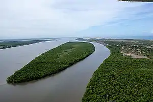 A mangrove forest of Mangue Seco, Bahia. | |
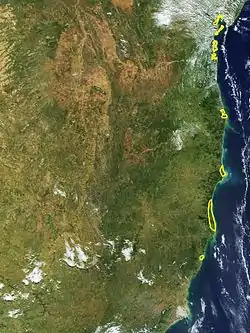 map of the Bahia mangroves ecoregion (outlined in yellow). | |
| Ecology | |
| Realm | Neotropical |
| Biome | mangroves |
| Borders | Bahia coastal forests and Atlantic Coast restingas |
| Geography | |
| Area | 2,100 km2 (810 sq mi) |
| Country | Brazil |
| States | Bahia and Espírito Santo |
| Conservation | |
| Conservation status | Critical/endangered |
Geography
The Bahia mangrove habitats occupy minor bays, estuaries, and river inlets along the coast from Recôncavo on Todos os Santos Bay in Bahia State; north to the Doce River in Espírito Santo State.
The total ecoregion comprises 2,100 square kilometers (800 square miles)) of shallow coastal waters and land.
Flora
Mangrove tree species include typical Atlantic Ocean tropical mangrove species, the red mangrove (Rhizophora mangle) of the Rhizophoraceae, the black mangrove (Avicennia germinans) of the Acanthaceae, and the white mangrove (Laguncularia racemosa) of the Combretaceae family.
Conservation
Clearing the mangrove forests for development is the greatest conservation threat currently. The mangroves are threatened by coastal urban sprawl, and by managed aquiculture enterprises, such as shrimp farms in Salinas da Margaridas.
Rising sea level from global climate change is of concern for the future of the Bahia mangroves.
See also
- List of plants of Atlantic Forest vegetation of Brazil — flora of its diverse ecoregions.
- Ecoregions in the Atlantic Forest biome
- Mangrove ecoregions
- List of ecoregions in Brazil