Baierbrunn
Baierbrunn is a municipality in the district of Munich in the south-German state Bavaria. It is located between Schäftlarn and Pullach on the Bundesstraße 11 and consists of the two villages Baierbrunn and Buchenhain. Baierbrunn has a stop on the S7 of the Munich S-Bahn.
Baierbrunn | |
|---|---|
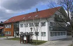 Town hall | |
 Coat of arms | |
Location of Baierbrunn within Munich district 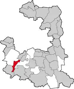 | |
 Baierbrunn  Baierbrunn | |
| Coordinates: 48°1′N 11°29′E | |
| Country | Germany |
| State | Bavaria |
| Admin. region | Oberbayern |
| District | Munich |
| Government | |
| • Mayor | Wolfgang Jirschik (ÜWG) |
| Area | |
| • Total | 7.21 km2 (2.78 sq mi) |
| Elevation | 626 m (2,054 ft) |
| Population (2019-12-31)[1] | |
| • Total | 3,269 |
| • Density | 450/km2 (1,200/sq mi) |
| Time zone | UTC+01:00 (CET) |
| • Summer (DST) | UTC+02:00 (CEST) |
| Postal codes | 82065 |
| Dialling codes | 089 |
| Vehicle registration | M |
| Website | www.baierbrunn.de |
History
Some remains of a hillfort from the Early Middle Ages, called Birg, can be found on the area of the municipality of Baierbrunn. The earliest known mentioning of Baierbrunn was in 776 on a deed of gift from Kloster Schäftlarn. It became an independent municipality in 1818. The village of Buchenhain started 1900 with an inn called "Waldgasthof".
References
- "Tabellenblatt "Daten 2", Statistischer Bericht A1200C 202041 Einwohnerzahlen der Gemeinden, Kreise und Regierungsbezirke". Bayerisches Landesamt für Statistik und Datenverarbeitung (in German). July 2020.
Sources
- Alfred Hutterer: Am Brunnen der Baiern. Baierbrunn 1985
| Authority control |
|---|
This article is issued from Wikipedia. The text is licensed under Creative Commons - Attribution - Sharealike. Additional terms may apply for the media files.