Baldramsdorf
Baldramsdorf is a municipality in the district of Spittal an der Drau in the Austrian state of Carinthia.
Baldramsdorf | |
|---|---|
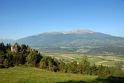 View from Mt Goldeck | |
 Coat of arms | |
 Baldramsdorf Location within Austria | |
| Coordinates: 46°48′N 13°27′E | |
| Country | Austria |
| State | Carinthia |
| District | Spittal an der Drau |
| Government | |
| • Mayor | Heinrich Gerber (SPÖ) |
| Area | |
| • Total | 37.94 km2 (14.65 sq mi) |
| Elevation | 584 m (1,916 ft) |
| Population (2018-01-01)[2] | |
| • Total | 1,866 |
| • Density | 49/km2 (130/sq mi) |
| Time zone | UTC+1 (CET) |
| • Summer (DST) | UTC+2 (CEST) |
| Postal code | 9805 |
| Area code | 04762 |
| Website | www.baldramsdorf.at |
Geography
The municipal area stretches west of Spittal an der Drau in the southern part of the Lurnfeld valley between the Drava river and the slopes of the Goldeck mountain, part of the Gailtal Alps. The municipality comprises the cadastral communities of Baldramsdorf and Gschieß.
History
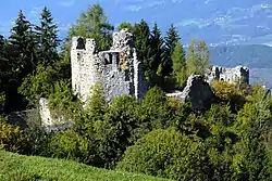
Both Baldramsdorf and Gschieß were first mentioned in an 1166 deed. Ortenburg Castle, located on a rock above the Unterhaus settlement, was already documented in the 11th century; it was probably erected from about 1090 onwards and finished in 1140. The former seat of the Counts of Ortenburg, who also founded the neighbouring town of Spittal in 1191, decayed after the extinction of the line in 1418. Today only ruins remain.
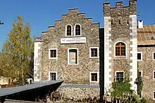
The Habsburg emperor Frederick III, having seized the former Ortenburg estates, had Unterhaus Castle (Paternschloss) erected below the medieval fortress, it was rebuilt from 1710 onwards as a Hieronymite monastery at the behest of the local Porcia princes, in order to encounter crypto-protestant practises in the area. The convent was dissolved in the course of the Josephinist reforms; the building today houses the First Carinthian Handicraft Museum.
Politics
Seats in the municipal assembly (Gemeinderat) as of 2015 local elections:
- Social Democratic Party of Austria (SPÖ): 8
- Liste für Baldramsdorf (Independent): 4
- Freedom Party of Austria (FPÖ): 3
References
- "Dauersiedlungsraum der Gemeinden Politischen Bezirke und Bundesländer - Gebietsstand 1.1.2018". Statistics Austria. Retrieved 10 March 2019.
- "Einwohnerzahl 1.1.2018 nach Gemeinden mit Status, Gebietsstand 1.1.2018". Statistics Austria. Retrieved 9 March 2019.
External links
| Wikimedia Commons has media related to Baldramsdorf. |
- Municipal site (in German)
- Handicraft Museum (in German)