Banat Military Frontier
The Banat Military Frontier or simply Banat Frontier (Serbian: Банатска крајина/Banatska krajina) was a district of the Habsburg Monarchy's Military Frontier located in the Banat region. It was formed out of territories of the Banat of Temeswar. Today, the territory is split between Hungary, Serbia and Romania.
| Banat Military Frontier | |||||||
|---|---|---|---|---|---|---|---|
| district of the Military Frontier, Habsburg Monarchy | |||||||
| 1751–1873 | |||||||
.png.webp) 1849–60 political map | |||||||
| History | |||||||
• Established | 1751 | ||||||
• Disestablished | 1873 | ||||||
| |||||||
| Today part of | Hungary, Serbia, Romania | ||||||
Geography
The Frontier was divided into Serb (Illyrian), German (Danube Swabian) and Romanian (Vlach) sections. It included parts of modern-day Banat and the south-eastern part of Bačka region, known as Šajkaška. Some of the important cities and places were: Pančevo, Bela Crkva, Titel, Žabalj, Alibunar, Kovin, and Caransebeş.
History
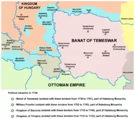
The military province of Habsburg Monarchy known as the Banat of Temeswar was created in 1718. In 1751, Maria Theresa introduced a civil administration for the northern part of the province. The southern part remained under military administration and was organized as the Banat Military Frontier. In 1849, this part of the Military Frontier bordered the Principality of Serbia to the south, Voivodeship of Serbia and Banat of Temeschwar to the north, Transylvania and Wallachia to the east, and the Slavonian Military Frontier to the west. It remained a part of the Habsburg Military Frontier until it was abolished in 1871.
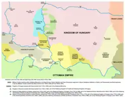
 Map of Military Frontier sections in Syrmia, Bačka, and Pomorišje in 1718–44
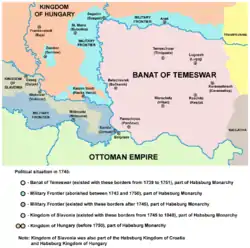 Map of Military Frontier sections in Syrmia, Bačka, and Pomorišje in 1744–50
 Map of Military Frontier sections in Syrmia, Bačka, and Banat in 1751–1778
Administration
| Division | Seat | Notes |
|---|---|---|
| German | Pančevo | |
| Romanian (Vlach) | Caransebeș | |
| Serbian (Illyrian) | Bela Crkva | |
Demographics
1857
Total of 386,255 people:[1]
- 314,514 (81,43%) Eastern Orthodox
- 51,860 (13,43%) Roman Catholics
- 19,418 (5,03%) Evangelists
- 393 (0,1%) Jews
- 70 (0,01%) others
References
- Bundesministerium für Inneres (1859). Statistische Übersichten Über Die Bevölkerung und Den Viehstand Von Österreich. Nach Der Zählung Vom 31. October 1857. p. 176.