Bangar, Temburong
Bangar is a mukim in the Temburong District of Brunei. It is located in the north-west of the Temburong District bordering Mukim Labu to the north, Mukim Batu Apoi to the east, Mukim Amo to the south-east, Mukim Bokok to the south-west and Limbang, Sarawak (Malaysia) to the west and north. Mukim Bangar has one island within its vicinity which is Pulau Kibi. Bangar has a total area of 113 square kilometres (44 sq mi);[1] as 2016, it had a total population of 2,696.[2]
Bangar
Mukim Bangar | |
|---|---|
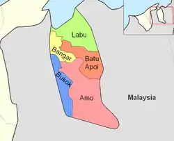 Mukim location | |
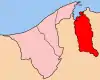 Temburong District in Brunei | |
| Country | Brunei |
| District | Temburong |
| Government | |
| • Penghulu | Abdul Rahman bin Merusin |
| Area | |
| • Total | 113 km2 (44 sq mi) |
| Population (2016)[2] | |
| • Total | 2,696 |
| • Density | 24/km2 (62/sq mi) |
| Time zone | UTC+8 (Brunei Standard Time) |
Administration
Bangar is administered as a mukim or subdistrict, the second-level administrative division of Brunei. It is one of the five mukim subdivisions of Temburong District.[3] As a mukim, Bangar is headed by a penghulu, and the incumbent is Abdul Rahman bin Merusin, which took the office since 2015.[1]
Areas and divisions
Mukim Bangar includes these following areas:
- Pekan Bangar Lama
- Pekan Bangar Baru
- Perkemahan Bangar
- Kampong Menengah
- Kampong Sungai Sulok
- Kampong Sungai Tanit
- Kampong Sungai Tanam
- Kampong Balayang
- Kampong Semamang
- Kampong Buang Bulan
- Kampong Belingus
- Kampong Batang Tuau
- Kampong Seri Tanjong Belayang
- Kampong Puni
- Kampong Ujong Jalan
Other locations
Other locations within the mukim include:
- Pulau Kibi
Border crossings
There is a road border crossing into Malaysia's Sarawak state at Kampung Ujung Jalan, 5km from Bangar town. Previously the crossing had to be done by vehicular ferry across the Pandaruan River which forms the Brunei-Malaysia border. However, a Malaysia-Brunei Friendship Bridge had been constructed and opened to vehicular traffic on 8 December 2013.
Both Brunei and Malaysia have constructed new customs, immigration and quarantine checkpoints at the location of the crossing. The Brunei checkpoint is called the Ujung Jalan Immigration Checkpoint. Before the construction of the bridge, the Brunei customs, immigration and quarantine checkpoint was housed in a wooden building in Kampung Puni, 500m from the ferry landing towards Bangar, while Malaysian customs and immigration procedures had to be carried out at Limbang wharf in Limbang, 15km away as there was no checkpoint at Pandaruan.
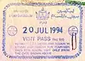 Old Brunei entry stamp from the Puni border checkpoint before the opening of the Ujung Jalan checkpoint.
 Ujung Jalan checkpoint exit stamp.
References
- "Jabatan Daerah Temburong, Kementerian Hal Ehwal Dalam Negeri - MUKIM BANGAR". temburong.gov.bn (in Malay). Retrieved 2018-01-09.
- "Data Set Population Temburong Population by Mukims" (XLSX). www.data.gov.bn. Retrieved 2018-01-08.
- "Jabatan Daerah Temburong, Kementerian Hal Ehwal Dalam Negeri - Profil Mukim". temburong.gov.bn (in Malay). Retrieved 2018-01-09.
