Barbaria (East Africa)
Barbaria was the name used by the ancient Greeks for a region along Northeast Africa containing several city-states. That would dominate trading in the Red Sea and the Indian Ocean.The corresponding Arabic term, bilad al-Barbar (land of the Barbar), was in use in the Middle Ages.[1]
Etymology
The exact etymology and origins of Barbaria/Berber is uncertain a number of theories have been put forward.
One theory is that the toponym originates from the Greek 'barbaroi,' meaning 'babblers,' used to mean non-Greeks, i.e., people who didn't speak Greek; from the sound that the Greeks thought they were making: 'bar bar bar bar...'[2]
Another theory is that according to early hieroglypical records the toponym may have originated as an ethnonym for the ancient Puntites under brbrta employed by the Ancient Egyptians [3][4]
The name of Barbaria is preserved today in the name of the Somali city of Berbera, [1] the city known to the Greeks as Malao.[5] It is also preserved in the market town Berber, Sudan [6]
Geography
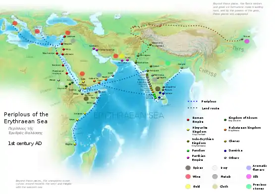
According to the Periplus of the Erythraean Sea, a 1st-century travelogue written by a Greek merchant based in Alexandria, Barbaria extended from the border of Egypt just south of Berenice Troglodytica to just north of Ptolemais Theron. From there to the Bab-el-Mandeb was the kingdom ruled by Zoskales (possibly Aksum), after which the "rest of Barbaria" extended to Opone. This second Barbaria was the location of the so-called "far-side" ports. In the Geography of Ptolemy (2nd century), Barbaria is said to extend even further, as far south as Zanzibar, although the land south of Opone is called Azania in the Periplus.[7][8]
The barbary cities of Nikon, Malao, Damo, and Mosylon thrived along the Indian Ocean of the Somali coast in antiquity, the names of these urban areas and their areas were accounted for in the periplus of the Erythraean ocean a travelog of a Greek merchant.[9]
The northern shorelines of Somalia were for the most part level and desolate and past the waterfront fields, there were bone-dry mountains and an enormous inland level. Many different types of colorful fragrant trees developed wild in the good country zone, including some old types of wiped out cinnamon.[10]
The Monumentum Adulitanum, a 3rd-century bilingual Greek–Ge'ez inscription from Adulis, describes how the King of Aksum "subjugated the peoples of Rauso who live in the midst of incense-gathering Barbarians between great waterless plains". In context, the term Barbarians must refer to the inhabitants of the Barbaria of the Greek sources, which is implied to be a land south of the Aksumite kingdom. The reference to incense suggests that it contains the Land of Incense mentioned later in the same inscription, which is identifiable with the Aromata of the Greek sources. According to Glen W. Bowersock, ancient Barbaria may be safely identified with Somalia.[11]
Political structure
The Periplus states that barbaria was not governed by an individual ruler however each port was administrated by a chief. The vast majority of the settlements were found inshore, each port city had its own unmistakable character some were unwelcoming to the Romans others welcoming and often depended on the conditions and perspectives of the locals.[10]
The periplus described Barbarias method of governance as decentralized and consisting of a number of autonomous city-states, these city-states would be governed by their respective local chief or tyrannida.[12] Some cities the berbers living in them were described as very unruly an apparent reference to their independent streak. Whereas others port cities like Malao the natives were described to be peaceable.[13][14]
Market Towns
The ports in the Northern Somali coast specifically Mosylon, Mundus, Opone, Malao, and Avalites were trading commodities, for instance, incenses frankincense myrrh and cassia which would all be conveyed to The Roman domain explicitly Roman Egypt, the Somali ports would also likewise trade with the ports in southern Arabia. The Somali coast formed a section of the greater incense trade alongside Southeast Asia, South Asia, and southern Arabia on the Red Sea. Incense was mainstream in the Mediterranean region and in Europe, where the products would be consistently used in strict religious purposes and for other everyday uses, this has made incense a noteworthy commodity in the Indian Ocean trade.[15]
The Somalis would manufacture the city-states of Opone, Sarapion, Mundus Mosylon, these urban areas gave a market to products rolling in from the ancient world. They would utilize a boat called Beden as their main vessel exchange vessel, the boat was dependable for its speed and solidness and was held together by coconut strands. While the Nabateans of northern Arabia were kept from exchanging with India the Somalis from headquartered in their city-states proceeded with their exchange with India for a considerable length of time to come.[16]
The port of Avalites would export out items, such as spices, ivory, and small amounts of myrrh, the myrrh in Avalites was supposed to be of acceptable quality then those discovered elsewhere in the ancient world at that point. the method used in sending out these commodities would come in the form of rafts navigated by the people of Avalites which would then be sold to the Roman World.[17]
The port of Malao was centered in the modern-day city of Berbera, Malao was known to have traded items, such as, Myrrh frankincense and spices which were sent out to Arabia and the Roman world.[18]
The port town of Opone in present-day Hafun situated on the Hafun peninsula would be a focal point of trade for traders rolling in from Phoenicia Egypt Greece Persia, Yemen, Nabatia as well as the Roman realm. Among the commodities exchanged in Opone included spices silks and different goods, Opone was likewise at the core of the ancient cinnamon exchange.[18]
The Barbaria had no central authority but was ruled by local chieftains. Barbaria would include the African side of the Bab el Mandeb the northern bank of Somalia directly towards Cape Guardafui and a short stretch south of the cape towards Ras Hafun.[19]
See also
References
- Michael Peppard, "A Letter Concerning Boats in Berenike and Trade on the Red Sea", Zeitschrift für Papyrologie und Epigraphik 171 (2009), pp. 193–198.
- http://lancsngfl.ac.uk/curriculum/literacy/lit_site/html/fiction/herakles/dictionary/dictionary.htm
- Palmyre, Bilan et perspectives: Colloque de Strasbourg (18-20 Octobre 1973) Page 114
- Geographia Rabbinica: The Toponym Barbaria: DAVID M. GOLDENBERG: University of Pennsylvania
- David M. Goldenberg, "Geographia Rabbinica: The Toponym Barbaria", Journal of Jewish Studies 50, 1 (1999), pp. 67–69.
- . Encyclopædia Britannica. 03 (11th ed.). 1911. p. 764.
- Lionel Casson (ed.), The Periplus Maris Erythraei: Text with Introduction, Translation, and Commentary (Princeton University Press, 1989), p. 45.
- Lionel Casson, "Barbaria", in Glen W. Bowersock, Peter Brown and Oleg Grabar (eds.), Late Antiquity: A Guide to the Postclassical World (Belknap Press of Harvard University Press, 1999), p. 334.
- Abdullahi, Abdurahman. Making Sense of Somali History: Volume 1 By Abdullahi, Abdurahman.
- McLaughlin, Raoul (11 September 2014). The Roman Empire and the Indian Ocean: The Ancient World Economy and the Kingdoms of Africa, Arabia and India. ISBN 9781783463817.
- Glen W. Bowersock, The Throne of Adulis: Red Sea Wars on the Eve of Islam (Oxford University Press, 2013), pp. 47, 51–53.
- Mohamed Diriye Abdullahi, Culture and Customs of Somalia, (Greenwood Press, 2001), pp.13–14
- Schoff, Wilfred Harvey (1912). The Periplus of the Erythraean Sea: Travel and Trade in the Indian Ocean by a Merchant of the First Century. London, Bombay & Calcutta. Retrieved 7 June 2016.
- Periplus of the Erythraean Sea, Schoff's 1912 translation
- Chew, Sing C (2010-05-06). The Southeast Asia Connection: Trade and Polities in the Eurasian World Economy, 500 BC–AD 500. Berghahn Books. ISBN 978-1785337888.
- kete, Molefi (2010-05-06). The History of Africa: The Quest for Eternal Harmony. ISBN 9781351685153.
- Lunde, Paul (2004). https://books.google.com/books?id=e8. Missing or empty
|title=(help) - Chandra, S. (2004). https://books.google.com/books?id=ZD. Missing or empty
|title=(help) - Casson, Lionel (2010-05-06). The Periplus Maris Erythraei: Text with Introduction, Translation. Princeton University Press. ISBN 978-0691040608.