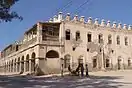
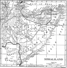
Berbera
Berbera (Somali: Barbara, Arabic: بربرة) is the capital of the Sahil region of Somaliland and is the main sea port of the country. Berbera is a coastal city and was the former capital of the British Somaliland protectorate before Hargeisa.[3][4]
Berbera
Barbara بربرة | |
|---|---|
City | |
   | |
Local council seal of Berbera | |
.svg.png.webp) Berbera Location in Somaliland 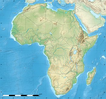 Berbera Berbera (Africa) | |
| Coordinates: 10°26′08″N 045°00′59″E | |
| Country | |
| Region | Sahil |
| District | Berbera |
| Government | |
| • Mayor | Abdishakur Iddin[1] |
| Elevation | 3 m (10 ft) |
| Population (2005)[2] | |
| • Total | 60,753 |
| Demonym(s) | Berberawi |
| Time zone | UTC+3 (EAT) |
In antiquity, Berbera was part of a chain of commercial port cities along the Somali seaboard. During the early modern period, Berbera was the most important place of trade in the Somali Peninsula.[5] It later served as the capital of the British Somaliland protectorate from 1884 to 1941, when it was replaced by Hargeisa. In 1960, the British Somaliland protectorate gained independence as the State of Somaliland and united five days later with the Trust Territory of Somalia (the former Italian Somalia) to form the Somali Republic.[6][7] Located strategically on the oil route, the city has a deep seaport, which serves as the region's main commercial harbour.
History
Antiquity
Berbera was part of the classical Somali city-states that engaged in a lucrative trade network connecting Somali merchants with Phoenicia, Ptolemic Egypt, Ancient Greece, Parthian Persia, Saba, Nabataea and the Roman Empire. Somali sailors used the ancient Somali maritime vessel known as the beden to transport their cargo.[8]
Berbera preserves the ancient name of the coast along the southern shore of the Gulf of Aden. It is believed to be the ancient port of Malao (Ancient Greek: Μαλαὼ) described as 800 stadia beyond the city of the Avalites, described in the eighth chapter of the Periplus of the Erythraean Sea, which was written by a Greek merchant in the first century AD. In the Periplus it is described as:
"After Avalites there is another market-town, better than this, called Malao, distant a sail of about eight hundred stadia. The anchorage is an open roadstead, sheltered by a spit running out from the east. Here the natives are more peaceable. There are imported into this place the things already mentioned, and many tunics, cloaks from Arsinoe, dressed and dyed; drinking-cups, sheets of soft copper in small quantity, iron, and gold and silver coin, but not much. There are exported from these places myrrh, a little frankincense, (that known as far-side), the harder cinnamon, duaca, Indian copal and macir, which are imported into Arabia; and slaves, but rarely."
— Chap.8.[9]
Middle Ages
Duan Chengshi, a Chinese Tang dynasty scholar, described in his written work of AD 863 the slave trade, ivory trade, and ambergris trade of Bobali, which is thought to be Berbera. The great city was also later mentioned by the Islamic traveller Ibn Sa'id as well as Ibn Battuta in the thirteenth century.[10]
In Abu'l-Fida's, A Sketch of the Countries (Arabic: تقويم البلدان), the present-day Gulf of Aden was called the Gulf of Berbera, which shows how important Berbera was in both regional and international trade during the medieval period.[11][12]
Legendary Arab explorer Ahmad ibn Mājid wrote of Berbera and a few other notable landmarks and ports of the northern Somali coast and referred to what is now the Gulf of Aden as the Gulf of Berbera. He also included Zeila and it's archipelago, Siyara, Heis, Alula, Ruguda, Maydh, El-Sheikh and El-Darad.[13]
Berbera was an important and well built settlement that served as a major harbor port for several successive Somali Kingdoms in the Middle Ages like the early Adal Kingdom, Ifat Sultanate and Adal Sultanate.[14]
Berbera, along with Zeila, were the two most important ports situated inside the Adal Sultanate, and they provided vital political and commercial links with the wider Islamic World:
Original Text:
To Adea belongs a very good Port, call’d Barraboa, whofe chief City is Arat, obeys a King, who is an enemy to the Abiffines. Barraboa and Zeila are places of great Trade, by reafon of the conveniency of their Ports, towards the entry into the Red-Sea.
Modern English:
To Adel belongs a very good port, called Barbara, whose chief city is Harar, obeys a King, who is an enemy to the Abyssinians. Barbara and Zeila are places of great trade, by reason of the conveniency of their ports, towards the entry into the Red Sea.[15]
Along with other ports and settlements in East Africa and the Horn, explorers Duarte Barbosa and Leo Africanus wrote brief accounts of the port town of Berbera in the early sixteenth century, detailing her historic trading links with Aden and Khambat (Cambay):
Further on, on the same coast, is a town of the Moors [Muslims] called Barbara; it has a port, at which many ships of Adeni and Cambay touch with their merchandise, and from there those of Cambay carry away much gold, and ivory, and other things, and those of Aden take many provisions, meat, honey, and wax, because, as they say, it is a very abundant country.[16]
At Barbara many ships of Aden and Cambay arrive with their merchandize for exchange; from whence they receive much flesh, honey, wax and victuals for Aden; and gold, ivory and other things for Cambay.[17]
According to Selman Reis, an ambitious Ottoman Red Sea admiral, Berbera was rich with pearls, and the amount of merchandise and trade consisting of "gold, musk and ivory" present at Berbera, on the Somali coast, was described by Selman as "limitless".[18]
Early Modern to Pre-Colonial
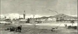
One certainty about Berbera over the following centuries was that it was the site of an annual fair, held between October and April, which Mordechai Abir describes as "among the most important commercial events of the east coast of Africa."[19] The major Somali sub-clans of the Isaaq in Somaliland, caravans from Harar and the interior, and Banyan merchants from Porbandar, Mangalore and Mumbai gathered to trade. All of this was kept secret from European merchants.[20] Lieutenant C. J. Cruttenden, who wrote a memoir describing this portion of the Somali coast dated 12 May 1848, provided an account of the Berbera fair and an account of the historic environs of the town: "an aqueduct of stone and chunam, some nine miles [15 km] in length", which had once emptied into a presently dry reservoir adjacent to the ruins of a mosque. He explored part of its course from the reservoir past a number of tombs built of stones taken from the aqueduct to reach a spring, above which lay "the remains of a small fort or tower of chunam and stone ... on the hill-side immediately over the spring." Cruttenden noted that in "style it was different to any houses now found on the Somali coast", and concluded with noting the presence in "the neighbourhood of the fort above mentioned [an] abundance of broken glass and pottery ... from which I infer that it was a place of considerable antiquity; but, though diligent search was made, no traces of inscriptions could be discovered."[21]
Berbera was the most important port in the Somali Peninsula between the 18th–19th centuries. For centuries, Berbera had extensive trade relations with several historic ports in Arabia and the Indian subcontinent. Additionally, the Somali and Ethiopian interiors were very dependent on Berbera for trade, where most of the goods for export arrived from.[22]
One of the earliest pre colonial accounts comes from Ibrahim Punkar who wrote a memoir in 1801 and letter in 1809 to the Governor of Bombay John Duncan. Noting that Berbera had 5-6 towers with armed guards, he would go to describe the trade and general outlook of the city. Noting the Somali inhabitants adhering to the Shafi'i school of Sunni Islam significant trade came from Harar in the interior alongside Gondar and Shewa. Cloth, rice and tobacco came from Kutch in Gujarat and Muscat with Mocha, Jeddah and Al Mukalla being the source of dates and tin. Punkar stated that the Somalis of the area were skilled musketeers and possessed powerful cavalry and knowledge of archery but were often internally divided but united against common enemies. All foreigners including Arabs and Indians who often frequented Berbera were prohibited from venturing further inland, lest they access the lucrative trade of Harar directly and bypass the Somalis.[23]
During the 1833 trading season, the port town swelled up to 70,000 people, and upwards of 6,000 camels laden with goods arrived from the interior within a single day. Berbera was the main marketplace in the entire Somali seaboard for various goods procured from the interior, such as livestock, coffee, frankincense, myrrh, acacia gum, saffron, feathers, wax, ghee, hide (skin), gold and ivory.[24] In the trading season of 1840, French explorer Charles-Xavier Rochet d'Héricourt visited Berbera and estimated the total exports of the season to be around thirteen times greater than that of Massawa.[25]
According to a trade journal published in 1856, Berbera was described as “the freest port in the world, and the most important trading place on the whole Arabian Gulf.”:
“The only seaports of importance on this coast are Feyla [Zeila] and Berbera; the former is an Arabian colony, dependent of Mocha, but Berbera is independent of any foreign power. It is, without having the name, the freest port in the world, and the most important trading place on the whole Arabian Gulf. From the beginning of November to the end of April, a large fair assembles in Berbera, and caravans of 6,000 camels at a time come from the interior loaded with coffee, (considered superior to Mocha in Bombay), gum, ivory, hides, skins, grain, cattle, and sour milk, the substitute of fermented drinks in these regions; also much cattle is brought there for the Aden market.”[26]
Historically, the port of Berbera was controlled indigenously between the mercantile Reer Ahmed Nur (Ayyal Ahmed) and Reer Yunis Nuh (Ayyal Yunis) sub-clans of the Sa'ad Musa, Habr Awal. These two sub-clans effectively administered the trade of the town, especially in the dealings of all transactions and brokerage between various parties to issuing protection agreements towards the foreign Arab and Indian traders. In the year 1845, the two sub-clans had a dissension over the control of the trade of Berbera, which lead to a wider altercation where each side sought outside support. With the backing of Haji Sharmarke Ali Saleh, the Reer Ahmed Nuh drove out their kinsmen and declared themselves the sole commercial masters of Berbera. The defeated Reer Yunis Nuh moved westwards and established the port of Bulhar which later, for a brief period, became a trading rival to nearby Berbera.[27][28]
Before this, and prior to the British settlement at Aden in 1839, the Ayyal Yunis and Ayyal Ahmed lineages of the Habr Awal clan had held Berbera and jointly managed its trade, sharing in the profits on all commercial transactions as ‘protectors’ (abans) of foreign merchants from Arabia and India. When under the stimulus of developments at Aden the port’s prosperity markedly increased, the numerically dominant Ayyal Yunis drove out their rival kinsmen and declared themselves commercial masters of Berbera. This led to a feud in which each side sought outside help; the defeated Ayyal Ahmed turned to Haji Shirmarke ‘Ali and his Habr Yunis clansmen for support. With this backing, they were then able to re-establish themselves and to expel the Ayyal Yunis who moved to the small roadstead of Bulhar, some miles to the west of Berbera.[29]
However, Sharmarke's actions was ultimately a political ruse to control Berbera for himself, which he ultimately achieved for several years.[30] Berbera commanded most of the trade traffic with the Somali and Ethiopian interiors. The two main caravan trade routes from Berbera extended to Harar and Shewa in the west, and to the Shebelle basin in the south (although some caravans traveled to/from as far as the Jubba River).[31]
Moreover, the inland caravan trade routes were also concurrently used as pilgrim routes during the trading season by Somali Hajj pilgrims who resided in the deep interior:
“The two routes to East Africa mentioned, namely that by the sea-board, and the second by way of Berbera, through Somali-land, are essentially trade routes, and are only subordinately and accidentally pilgrim routes. The Berbera route is that usually taken advantage of by the Somali pilgrims (except those living near the coast); and when the season of the pilgrimage agrees with the period when the annual caravans depart for Berbera, as it did in 1865, this route is always preferred; but when the seasons do not agree, the pilgrims strike off from the caravan route, and make their way direct to Mussuah, their course being to the east of Abyssinia.”[32]
Mocha, Aden, Jeddah and several other ports in Arabia had constant contact with Berbera in regard to general trade and commerce:
Berbera was a major port of considerable antiquity which traded, with Shoa, Harar and the country of the interior, as well as with Jeddah, Mocha, Aden and other ports of Arabia and lands to the east even further afield.[33]
In the early years of the nineteenth century, the Somalis of Berbera had a navigation act where they excluded Arab vessels and brought the goods and produce of the interior in their own ships to the Arabian ports:
Berbera held an annual fair during the cool rain-free months between October and April. This long drawn out market handled immense quantities of coffee, gum Arabic, myrrh and other commodities. These goods in the early nineteenth century were almost exclusively handled by Somalis who, Salt says, had "a kind of navigation act by which they exclude the Arab vessels from their ports and bring the produce of their country either to Aden or Mocha in their own dows."[34]
In much of the 19th century, the trade between Berbera and Aden was so important to the later that when disturbances effected the Berbera trading season, Aden too suffered as a result. According to Captain Haines, who was then the colonial administrator of Aden (1839-1854), 80% of Aden's revenue in 1848 was derived from duties charged on imported goods from Berbera. Additionally, most of the coffee imported by Mocha (centre of the coffee trade in early modern times) arrived from Habr Awal Somali merchants from Berbera, who procured the coffee beans from the environs of Harar. Although the coffee beans were grown in Harar (present-day Ethiopia), the coffee was named Berbera Coffee in the international market, and the beans were considered superior to the locally grown varieties in Yemen.[26]
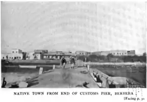
.jpg.webp)
Among the exports which went out from Berbera and other similar fairs on the Somali coast was coffee which came from far inland at Harrar. Haines claimed that two thirds of the coffee shipped at Mocha came from this source. There was also a rising export of gum arabic which was much in demand in Europe and the United States. There were small quantities of those ancient and still valuable products, myrrh and frankincense. And there were hides and skins and flocks of sheep and goats for which the Aden garrison created a substantial demand. In the 1840s this trade was so important to Aden that when disturbances in Somaliland on occasion delayed the closing of the Berbera fair until after the end of Aden’s financial year, Haines regarded the trade figures for that year as totally unreal. And well he might, for no less than 80% of Aden’s revenue as late as 1848 came from duties charged on products brought in from Berbera.[35]
According to Richard Francis Burton, who visited both Berbera and Harar during his travels, he repeated a famous Harari saying he heard in 1854:
"He who commands at Berbera, holds the beard of Harar in his hands."[36]
The British explorer Richard Burton made two visits to this port, and his second visit was marred by an attack on his camp by a group of local Somali warriors, and although Burton was able to escape to Aden, one of his companions was killed.[37] Burton, recognizing the importance of the port city wrote:
In the first place, Berberah is the true key of the Red Sea, the centre of East African traffic, and the only safe place for shipping upon the western Erythraean shore, from Suez to Guardafui. Backed by lands capable of cultivation, and by hills covered with pine and other valuable trees, enjoying a comparatively temperate climate, with a regular although thin monsoon, this harbour has been coveted by many a foreign conqueror. Circumstances have thrown it as it were into our arms, and, if we refuse the chance, another and a rival nation will not be so blind.[38]
British Somaliland
After signing successive treaties with the various clans of the northern Somali coast between 1884–1886, the British established a protectorate in the region referred to as British Somaliland.[39] The British garrisoned the protectorate from Aden and administered it from their British India colony until 1898. British Somaliland was then administered by the Foreign Office until 1905 and afterwards by the Colonial Office.
Despite Berbera's strategic location, being the only port with a sheltered harbor on the southern side of the Gulf of Aden (the gateway to the Suez Canal), the British later came to regret their nominal control of the region. In fact, Winston Churchill once visited Berbera in 1907 when he was Under-Secretary of State for the Colonies, and he noted the protectorate be abandoned, since it was "unproductive, inhospitable, and the people are very hostile to occupation."[40] The stated purposes of the establishment of the protectorate were to "secure a supply market and to exclude the interference of foreign powers."[41] The British principally viewed the protectorate as a source for supplies of meat for their British Indian outpost in Aden through the maintenance of order in the coastal areas and protection of the caravan routes from the interior.[42][43] Colonial administration during this period did not extend infrastructure beyond the coast (which left the Somali clans within the protectorate with greater autonomy),[44] and contrasted with the more interventionist colonial experience of Italian Somalia.[45] However, there were plans in the early days of the protectorate to invest in major infrastructure projects such as the abandoned Berbera-Harar Railway initiative, which was vetoed by parliament on the grounds that it would harm the cordial agreement (entente cordiale) between France and Britain.[46]
A railway from Berbera to Harrar in Abyssinia was suggested as a means of bringing the interior of the protectorate within easy access, and at the same time of catering for the trade of Abyssinia; but it was vetoed on the ground that to compete with the French railway from Jibouti to Adis Ababa would be poor policy at a time when the entente cordiale had just been firmly cemented.[47]
In August 1940, during the East African Campaign, British Somaliland was briefly occupied by Italy after a large invasion force defeated British colonial troops at the Battle of Tug Argan. During this period, the British rounded up soldiers and governmental officials to evacuate them from the territory through Berbera. In total, 7,000 people, including civilians, were evacuated.[48] The Somalis serving in the Somaliland Camel Corps were given the choice of evacuation or disbandment; the majority chose to remain and were allowed to retain their arms.[49] In March 1941, the British forces recaptured the protectorate during Operation Appearance after a six-month occupation. The first WW2 Australian POWs were taken hostage here in 1940.
The British Somaliland protectorate gained its independence on 26 June 1960 as the State of Somaliland,[50][51] before uniting as planned five days later with the Trust Territory of Somalia (the former Italian Somalia) to form the Somali Republic.[7][50]
Modern
In the post-independence period, Berbera was administered as the part of the North-Western province of the Somali Republic. It served as the main livestock port of the republic and in the 1970s and 1980s, nearly all of the livestock exports went out through the port of Berbera via Isaaq livestock traders. The entire livestock exports accounted to upwards of 90% of the Somali Republic's entire export figures in a given year, and Berbera's exports alone provided over 75% of the nation's recorded foreign currency income at the time.[52][53] The main consumers were the wealthy gulf states and Saudi Arabia in particular.
As early as 1962, The Soviet Union agreed to assist the nascent Somali Republic towards the construction of modern port facilities and a military base, which was completed in 1969 and was called on by sixteen Soviet Ships in 1971.[54]Coinciding with the Ogaden War between The Somali Republic and Ethiopia in 1977, the Soviets left Berbera and the nation as a whole due to a disagreement, leaving the United States to arrive with a $40 million investment and new health facilities in 1980. By 1985, the city had an estimated population of 70,000, with the outbreak of the Somali Civil War the Somali National Movement (SNM) ousted government troops from the city following aerial bombardments and extrajudicial killings inflicted on the population by the government. With the downfall of General Siad Barre in 1991, the Northern region of the Somali Republic, declared the national independence of the Republic of Somaliland. A slow process of infrastructural reconstruction subsequently began in Berbera and other towns in the region.[55]
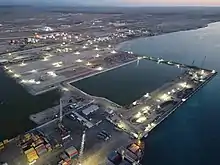
The city remains a competitive regional port and in 2016 a US$442 million agreement was reached between DP World and the government of Somaliland.[56] The deal involves enhancing and operating the regional trade and logistics hub at the Port of Berbera.[57] The project, which will be phased in, will also involve the setting up of a free zone.
On 1 March 2018, Ethiopia became a major shareholder following an agreement with DP World and the Somaliland Port Authority. DP World holds a 51% stake in the project, Somaliland 30% and Ethiopia the remaining 19%. As part of the agreement, the government of Ethiopia will invest in infrastructure to develop the Berbera Corridor as a trade gateway for the inland country, which is one of the fastest growing countries in the world. There are also plans to construct an additional berth at the Port of Berbera, in line with the Berbera master plan, which DP World has started implementing, while adding new equipment to further improve efficiencies and productivity of the port.[58]
The agreement comes as part of a larger government-to-government Memorandum of understanding between Government of the United Arab Emirates and the Government of Somaliland to further strengthen their strategic ties.[59] Somalia's attempts to obstruct and block the deal were frustrated and failed to stop the project from commencing.[60]
A rail link to Addis Ababa the capital of Ethiopia has remained a point of discussion and may materialize [61]
Geography
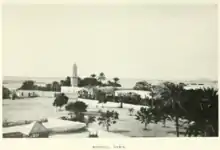
Location and habitat
_(2).jpg.webp)
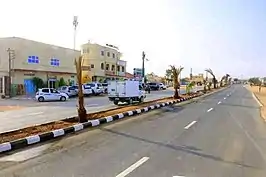
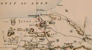
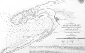
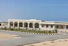
Berbera is located in coastal region of Somaliland Republic. An old port city, it has the only sheltered harbour on the southern side of the Gulf of Aden. The landscape around town, along with Somaliland's coastal lowlands, is semi-arid land.
Popular local beaches, such as Bathela and Batalale, have earned the city the nickname Beach City.
Climate
Berbera features a hot desert climate (Köppen climate classification BWh). It has long, very hot summers and short, hot winters, as well as very little rainfall. Average high temperatures consistently exceed 40 °C (104 °F) (104 °F) during nearly four months of summertime (June, July, August and September). Daytime heat on summer nights is high, with average low temperatures of around 30 °C (86 °F) (86 °F). During the coolest months of the year, average high temperatures remain above 29 °C (84 °F) (84.2 °F) and average low temperatures also surpass 20 °C (68 °F) (68 °F). Although precipitation is low, the relative humidity is very high throughout the year and the atmosphere is simultaneously moist. The combination of the desert heat and the excessive moisture make apparent temperatures reach extremely high levels. Annual average rainfall is minimal, with only 52 millimetres (2.0 inches) (2.05 in) of precipitation. There are between 5 and 8 rainy days on average annually. Bright sunshine likely occur during about 84% of the total daytime hours and average annual cloudiness is very low.
| Climate data for Berbera | |||||||||||||
|---|---|---|---|---|---|---|---|---|---|---|---|---|---|
| Month | Jan | Feb | Mar | Apr | May | Jun | Jul | Aug | Sep | Oct | Nov | Dec | Year |
| Record high °C (°F) | 35.3 (95.5) |
35.0 (95.0) |
35.0 (95.0) |
42.2 (108.0) |
47.3 (117.1) |
49.1 (120.4) |
47.7 (117.9) |
46.7 (116.1) |
46.0 (114.8) |
41.7 (107.1) |
36.7 (98.1) |
36.1 (97.0) |
49.1 (120.4) |
| Average high °C (°F) | 27.9 (82.2) |
29.2 (84.6) |
30.7 (87.3) |
31.0 (87.8) |
35.7 (96.3) |
42.8 (109.0) |
42.9 (109.2) |
41.9 (107.4) |
39.7 (103.5) |
33.1 (91.6) |
30.0 (86.0) |
28.6 (83.5) |
34.5 (94.1) |
| Daily mean °C (°F) | 25.0 (77.0) |
25.0 (77.0) |
26.1 (79.0) |
28.3 (82.9) |
31.1 (88.0) |
33.5 (92.3) |
36.1 (97.0) |
35.6 (96.1) |
33.3 (91.9) |
28.8 (83.8) |
26.7 (80.1) |
26.7 (80.1) |
30.0 (86.0) |
| Average low °C (°F) | 21.3 (70.3) |
21.6 (70.9) |
23.3 (73.9) |
25.2 (77.4) |
27.7 (81.9) |
31.0 (87.8) |
31.8 (89.2) |
31.1 (88.0) |
29.3 (84.7) |
24.0 (75.2) |
22.2 (72.0) |
21.6 (70.9) |
25.8 (78.4) |
| Record low °C (°F) | 14.4 (57.9) |
15.6 (60.1) |
16.7 (62.1) |
18.9 (66.0) |
20.6 (69.1) |
22.2 (72.0) |
20.6 (69.1) |
20.0 (68.0) |
17.8 (64.0) |
16.7 (62.1) |
16.1 (61.0) |
15.0 (59.0) |
14.4 (57.9) |
| Average precipitation mm (inches) | 8 (0.3) |
2 (0.1) |
5 (0.2) |
12 (0.5) |
8 (0.3) |
1 (0.0) |
1 (0.0) |
2 (0.1) |
1 (0.0) |
2 (0.1) |
5 (0.2) |
5 (0.2) |
52 (2.0) |
| Average precipitation days (≥ 1.0 mm) | 0.6 | 0.6 | 0.5 | 0.7 | 0.8 | 0.1 | 0.3 | 0.5 | 0.4 | 0.2 | 0.3 | 0.4 | 5.2 |
| Average relative humidity (%) | 78 | 79 | 79 | 81 | 73 | 49 | 44 | 45 | 51 | 72 | 74 | 76 | 67 |
| Percent possible sunshine | 80 | 80 | 80 | 83 | 83 | 87 | 80 | 87 | 87 | 87 | 87 | 80 | 83 |
| Source 1: Arab Meteorology Book (average temperatures, humidity and precipitation),[62] Deutscher Wetterdienst (precipitation days, 1908–1950 and extremes)[63] | |||||||||||||
| Source 2: Food and Agriculture Organization: Somalia Water and Land Management (percent sunshine)[64] | |||||||||||||
Demographics
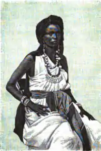
Historically, Berbera was inhabited by the Reer Ahmed Nuh and Yunis Nuh lineages of the Sa'ad Musa, Habr Awal.[65]
In more recent times, however, the Issa Musa sub-clan of the Habr Awal have come to make up the majority of the town's inhabitants, as well as a significant Habr Yunis minority belonging to the Musa Abdallah branch.[66]
Education
There are 30 primary schools operating in Berbera city totaling 63,641 students. The broader Berbera district has 49 schools serving 90,310 students.[67]
Economy
A number of products are exported through the Port of Berbera, including livestock, gum arabic, frankincense, and myrrh. Its seaborne trade is chiefly with Jeddah in Saudi Arabia, and Aden in Yemen, 240 kilometres (150 miles) to the north.[68] Additionally, goods from Ethiopia are also exported through the facility.[69] The seaside boasts watersport tourist activity such as scuba diving, snorkeling, surfing and coral reefs.[70]
Transportation
Berbera is the terminus of roads from Hargeisa and Burco. The city has one of Somaliland's major class seaports, the Port of Berbera.[71] It historically served as a naval and missile base for the Somali government. Following an agreement between the Somali Republic and the USSR in 1962, the port's facilities were patronized by the Soviets and was later significantly upgraded in 1969.[72] The Berbera seaport was later expanded for U.S. military use, after the Somali authorities strengthened ties with the American government.[73]
For air transportation, the city is served by the Berbera Airport. It has an extensive 4,140-metre (13,580-foot) runway.[74]
References
- "Somaliland and DP World celebrate 30-year concession for $442 million Port of Berbera (Somaliland) – Asoko Insight". Asoko Insight. Retrieved 2017-06-19.
- "Population data" (PDF). docs.unocha.org. 2005.
- "Issue 270". Archived from the original on 21 March 2016. Retrieved 28 March 2016.
- "The Transitional Federal Charter of the Somali Republic" (PDF). University of Pretoria. 1 February 2004. Archived from the original (PDF) on 25 March 2009. Retrieved 2 February 2010.
- Prichard, J. C. (1837). Researches Into the Physical History of Mankind: Ethnography of the African races. Sherwood, Gilbert & Piper. pp. 160.
- Cahoon, Ben. "Somalia". www.worldstatesmen.org.
- Encyclopædia Britannica, The New Encyclopædia Britannica, (Encyclopædia Britannica: 2002), p.835
- Journal of African History pg.50 by John Donnelly Fage and Roland Anthony Oliver
- Periplus of the Erythraean Sea, Schoff's 1912 translation
- I.M. Lewis, "The Somali Conquest of the Horn of Africa", Journal of African History, 1 (1960), p. 217
- Identifiants et Référentiels Sudoc Pour L'Enseignement Supérieur et la Recherche - Abū al-Fidā (1273-1331) (in French)
- Lewicki, Tadeusz (1974). Arabic External Sources for the History of Africa to the South of Sahara. Curzon Press. p. 33.
- "Ibn Majid". Medieval Science, Technology, and Medicine: An Encyclopedia. Routledge. 2005. ISBN 978-1-135-45932-1.
- I.M. Lewis, A Modern History of the Somali, fourth edition (Oxford: James Currey, 2002), p. 21
- Geography Rectified: or, a Description of the World in all its Kingdoms, Provinces, Countries, …, 1688, p. 528
- Barbosa, Duarte (1866). A Description of the Coasts of East Africa and Malabar in the Beginning of the Sixteenth Century (translated). Hakluyt Society. p. 17.
Note: The use of “Moor” in this context bares no relevance to the Moors of North Africa and the Iberian Peninsula. Rather, this naming is used to describe the local Muslim inhabitants of the settlement.
- Leo, Africanus (2010). The history and description of Africa and of the notable things therein contained (translated). Cambridge: Cambridge University Press. ISBN 1108012906.
- Özbaran, Salih (1994). The Ottoman response to European expansion: studies on Ottoman-Portuguese relations in the Indian Ocean and Ottoman administration in the Arab lands during the sixteenth century. Istanbul: Isis Press. pp. 108–109. ISBN 9754280665.
- w. Abir, Mordechai (1968). Ethiopia: The Era of the Princes; The Challenge of Islam and the Re-unification of the Christian Empire (1769-1855). London: Longmans. p. 16.
- Abir, Era of the Princes, p. 17
- C. J. Cruttenden, "Memoir on the Western or Edoor Tribes, Inhabiting the Somali Coast of N.-E. Africa, with the Southern Branches of the Family of Darrood, Resident on the Banks of the Webbe Shebeyli, Commonly Called the River Webbe," Journal of the Royal Geographical Society of London, 19 (1849), pp. 54, 56
- Prichard, J. C. (1837). Researches Into the Physical History of Mankind: Ethnography of the African races. Sherwood, Gilbert & Piper. pp. 160.
- British East India Company (1811). Survey of the East Coast of Africa British Library: India Office Records and Private Papers. National Archives. p. 40-50.
- The Colonial Magazine and Commercial-maritime Journal, Volume 2. 1840. p. 22.
- Pankhurst, R. (1965). Journal of Ethiopian Studies Vol. 3, No. 1. Institute of Ethiopian Studies. p. 51.
- Hunt, Freeman (1856). The Merchants' Magazine and Commercial Review, Volume 34. p. 694.
- Transactions of the Bombay Geographical Society, 1849, Volume 8, p. 185.
- Z. H., Kour (1981). The History of Aden, 1839-72. Cass. p. 72.
- Lewis, I.M. (1965). The Modern History of Somaliland: from Nation to State. Praeger. p. 35.
- Africa in the Nineteenth Century Until the 1880s. Unesco. 1989. pp. 386.
- Christie (M.D.), James (1876). Cholera Epidemics in East Africa. Macmillan Publishers. pp. 133, 137.
- Christie (M.D.), James (1876). Cholera Epidemics in East Africa. Macmillan Publishers. p. 145.
- Pankhurst, R. (1965). Journal of Ethiopian Studies Vol. 3, No. 1. Institute of Ethiopian Studies. p. 44.
- Pankhurst, R. (1965). Journal of Ethiopian Studies Vol. 3, No. 1. Institute of Ethiopian Studies. p. 45.
- R. J., Gavin (1975). Aden Under British Rule, 1839-1967. C. Hurst & Co. Publishers. p. 53.
- Jonas, Raymond (2011). The Battle of Adwa. Harvard University Press. p. 74.
- Lewis, A Modern History, p. 36
- Richard Burton, First Footsteps in East Africa, Preface
- Hugh Chisholm (ed.), The encyclopædia britannica: a dictionary of arts, sciences, literature and general information, Volume 25, (At the University press: 1911), p.383.
- Samatar, Abdi Ismail The state and rural transformation in Northern Somalia, 1884–1986, Madison: 1989, University of Wisconsin Press, p. 31
- Samatar p. 31
- Samatar, p. 32
- Samatar, Unhappy masses and the challenge of political Islam in the Horn of Africa, Somalia Online retrieved 10-03-27
- Samatar, The state and rural transformation in Northern Somalia, p. 42
- McConnell, Tristan (15 January 2009). "The Invisible Country". Virginia Quarterly Review. Archived from the original on 13 June 2010. Retrieved 27 March 2010.
- "Berbera-Harrar Railway Survey Vol. 1".
- The Navy Everywhere, 1919. p. 244
- Playfair (1954), p. 178
- Wavell, p. 2724
- "Somaliland Marks Independence After 73 Years of British Rule" (fee required). The New York Times. 1960-06-26. p. 6. Retrieved 2008-06-20.
- "How Britain said farewell to its Empire". BBC News. 2010-07-23.
- de Waal, Alex. "CLASS AND POWER IN A STATELESS SOMALIA". ResearchGate.
- Somalia: A Government at War with Its Own People (PDF). Human Rights Watch. 1990. p. 213. Archived (PDF) from the original on 17 February 2017. Retrieved 25 November 2020.
- Yordanov, Radoslav A. (2016). The Soviet Union and the Horn of Africa during the Cold War: Between Ideology and Pragmatism. p. 103. ISBN 1498529100.
- Cities of the Middle East and North Africa: A Historical Encyclopedia edited by Michael Dumper, Bruce E. Stanley Page 93
- "Somaliland and DP World celebrate 30-year concession for $442 million Port of Berbera (Somaliland) – Asoko Insight". Asoko Insight. Retrieved 2017-06-19.
- "Somalia project opens up Africa for DP World". thenational.ae. 30 May 2016. Retrieved 30 May 2016.
- "Ethiopia acquires 19% stake in DP World Berbera Port" (PDF). Retrieved 21 May 2018.
- "Dubai's DP World Agrees to Manage Port in Somaliland for 30 Years". Wall Street Journal. 30 May 2016. Retrieved 30 May 2016.
- Reuters (2018-04-20). "DP World Should Rethink Port Deals in Somalia-Foreign Minister". The New York Times. ISSN 0362-4331. Retrieved 2018-04-22.
- "Can Ethiopia's railway bring peace to Somalia?". BBC. Retrieved 23 November 2015.
- "Appendix I: Meteorological Data" (PDF). Springer. Retrieved 22 October 2016.
- "Klimatafel von Berbera / Somalia" (PDF). Baseline climate means (1961–1990) from stations all over the world (in German). Deutscher Wetterdienst. Retrieved 22 October 2016.
- "Long term mean monthly sunshine fraction in Somalia". Food and Agriculture Organization. Archived from the original on 2016-10-05. Retrieved 4 November 2011.
- Lewis, I.M. (1965). The Modern History of Somaliland: from Nation to State. Praeger. pp. 35.
Before this, and prior to the British settlement at Aden in 1839, the Ayyal Yunis and Ayyal Ahmed lineages of the Habr Awal clan had held Berbera and jointly managed its trade, sharing in the profits on all commercial transactions as ‘protectors’ (abans) of foreign merchants from Arabia and India.
- Center for Creative Solutions (May 31, 2004), Ruin and Renewal: The Story of Somaliland, Hargeisa: Center for Creative Solutions, archived from the original on April 8, 2011, retrieved September 21, 2010,
The ‘Iise Muuse clan for whom Berbera and its environs are their traditional area of settlement saw it differently. Retrieved on 2011-12-15.
- "2011/2 Primary School Census Statistics Yearbook" (PDF).
- United States. Congress. House. Committee on Armed Services. Special Subcommittee to Inspect Facilities at Berbera, Somalia. (1975). Report of the Special Subcommittee to Inspect Facilities at Berbera, Somalia, to the Committee on Armed Services, House of Representatives, Ninety-fourth Congress, first session, July 15, 1975. Washington, D.C.: US Government Printing Office.
- "Ethiopia, Somaliland envisage exploiting Barbara port", Ethiopian News Agency, 29 July 2009 (accessed 1 November 2009)
- Somalia attractions, Berbera Seaside retrieved 29 November 2013
- "Istanbul conference on Somalia 21 – 23 May 2010 - Draft discussion paper for Round Table "Transport infrastructure"" (PDF). Government of Somalia. Retrieved 31 August 2013.
- Hanhimäki, Jussi M. (2013). The Rise and Fall of Détente: American Foreign Policy and the Transformation of the Cold War. Potomac Books, Inc. ISBN 978-1612345864.
- Intercontinental Press Combined with Inprecor, Volume 20, Issues 25-37. Intercontinental Press. 1982. p. 674.
- Schmitz, Sebastain (2007). "By Ilyushin 18 to Mogadishu". Airways. 14 (7): 12–17. ISSN 1074-4320.
External links
| Wikivoyage has a travel guide for Berbera. |
| Wikimedia Commons has media related to Berbera. |