Bardera
Bardera (Arabic: بااردىرآ, Somali: Baardheere) is an important agricultural city in Bardhere District, Gedo region of Somalia. It is the second most populous town in the Juba Valley, with Kismayo being the largest and most densely populated city in the region, and Garbahaarreey serving as Gedo's capital.[2] Bardera sits on the Jubba River around 250 km west of the city of Baidoa and is in a highland area. The city experiences extremely hot temperatures from December to April. Formerly known as the "Onion capital of the World" for its production of the vegetable, the name Bardera means tall palm trees. The palms were cut to construct native homes or midille. The trees are disappearing rapidly as locals make a unique drink from the oil of the palms.[3]
Bardera
بااردىرآ Baardheere | |
|---|---|
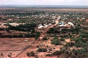 View over Bardera 1993 | |
| Nickname(s): Baladka raaxada | |
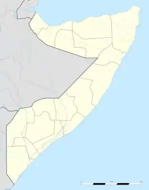 Bardera بااردىرآ Location in Somalia | |
| Coordinates: 2°20′N 42°17′E | |
| Country | |
| State | |
| Region | Gedo |
| District | District |
| Government | |
| • Bardera District Commissioner | [Mohamedkadar loslos] |
| Population | |
| • Estimate (2018) | 270,000 |
| Time zone | UTC+3 (EAT) |
History
Medieval
During the Middle Ages, Bardera and its surrounding area was part of the Ajuran Empire that governed much of southern Somalia and eastern Ethiopia, with its domain extending from Hobyo in the north, to Qelafo in the west, to Kismayo in the south.[4] Bardera was one of the most important cities in the Jubba river during the Ajuran period. It was an agricultural and commercial center. It had roads that connected the Benadir ports built by Ajuran. Bardhere provided many goods to the coastal provinces and many merchants across the region came to Bardera for trade..[5]
Early Modern
Bardera continued its agricultural and commercial legacy under Geledi Sultanate rule where it was surrounded by a citadel and with increased link between the coast and interior, both the Benadir ports and Bardera flourished with the city serving as the key ivory hub in the southern part of the Horn.[6][7]
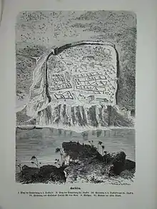
In the 1830s, a new militant extremist group rose in the citadel of Bardera, overlooking the Jubba River, and began imposing their interpretation of Islam on the surrounding regions, including the coastal city of Barawa, which they subdued and captured in 1840. In response, Sultan Yusuf Mahamud gathered his armies into a coalition and marched towards Bardera. The citadel was besieged and then burned to the ground, solidifying Sultan Yusuf's paramount authority in southern Somalia following his Conquest of Bardera.[8] Following the defeat of the Bardera recovered and remained relatively quiet until the eventual end of the Geledi Sultanate and subsequent incorporation into Italian Somaliland.[9]
Modern
After independence in 1960, the city was made the center of the official Bardera District. Bardera became the first place in Somalia were onions were grown commercially. This production began to increase rapidly but eventually fell off in the 1980s due to failed agricultural policies of the Somali government. The actual quality soil is in a narrow strip on either side of the river where pumps can feed private farms. Other produce such as sorghum can be found in Markabley/Hayranta although still in the district. German Explorer Carl Von Der Decken was killed at this same site in 1860, remnants of his wrecked ship remain.[10]
Health
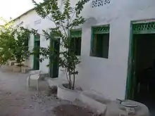
Bardera's main district hospital has been closed due to disrepair and neglect since November 1995. Functioning health centers include Somali Red Crescent MCH, HIRDA MCH, West Bardera Maternity Unit and East Bardera Mothers and Children's Hospital, now Bardera Maternity Hospital.[11]
Climate
Bardera has a hot semi-arid climate (Köppen climate classification BSh).
| Climate data for Bardera | |||||||||||||
|---|---|---|---|---|---|---|---|---|---|---|---|---|---|
| Month | Jan | Feb | Mar | Apr | May | Jun | Jul | Aug | Sep | Oct | Nov | Dec | Year |
| Record high °C (°F) | 45.0 (113.0) |
45.0 (113.0) |
49.0 (120.2) |
46.0 (114.8) |
45.0 (113.0) |
46.0 (114.8) |
42.0 (107.6) |
39.0 (102.2) |
43.0 (109.4) |
44.0 (111.2) |
43.0 (109.4) |
43.0 (109.4) |
49.0 (120.2) |
| Average high °C (°F) | 38.2 (100.8) |
39.3 (102.7) |
41.4 (106.5) |
38.0 (100.4) |
35.6 (96.1) |
34.0 (93.2) |
32.5 (90.5) |
33.1 (91.6) |
34.9 (94.8) |
36.1 (97.0) |
35.9 (96.6) |
36.7 (98.1) |
36.3 (97.3) |
| Daily mean °C (°F) | 29.7 (85.5) |
30.6 (87.1) |
31.5 (88.7) |
30.4 (86.7) |
29.0 (84.2) |
27.7 (81.9) |
26.2 (79.2) |
26.8 (80.2) |
28.2 (82.8) |
29.1 (84.4) |
28.8 (83.8) |
29.1 (84.4) |
29.0 (84.2) |
| Average low °C (°F) | 21.4 (70.5) |
22.0 (71.6) |
22.9 (73.2) |
22.9 (73.2) |
22.6 (72.7) |
21.3 (70.3) |
20.4 (68.7) |
20.9 (69.6) |
21.5 (70.7) |
22.1 (71.8) |
21.7 (71.1) |
21.6 (70.9) |
21.8 (71.2) |
| Record low °C (°F) | 16.0 (60.8) |
17.0 (62.6) |
18.0 (64.4) |
18.0 (64.4) |
18.0 (64.4) |
16.5 (61.7) |
15.0 (59.0) |
12.0 (53.6) |
16.0 (60.8) |
18.5 (65.3) |
14.0 (57.2) |
16.0 (60.8) |
12.0 (53.6) |
| Average precipitation mm (inches) | 6 (0.2) |
6 (0.2) |
22 (0.9) |
93 (3.7) |
55 (2.2) |
15 (0.6) |
25 (1.0) |
7 (0.3) |
6 (0.2) |
63 (2.5) |
57 (2.2) |
29 (1.1) |
384 (15.1) |
| Average precipitation days (≥ 0.1 mm) | 1 | 1 | 3 | 8 | 5 | 3 | 4 | 2 | 1 | 5 | 6 | 4 | 43 |
| Average relative humidity (%) | 63 | 61 | 61 | 69 | 72 | 71 | 69 | 70 | 69 | 73 | 72 | 69 | 68 |
| Mean monthly sunshine hours | 285.2 | 262.7 | 291.4 | 228.0 | 235.6 | 207.0 | 186.0 | 226.3 | 231.0 | 213.9 | 219.0 | 254.2 | 2,840.3 |
| Mean daily sunshine hours | 9.2 | 9.3 | 9.4 | 7.6 | 7.6 | 6.9 | 6.0 | 7.3 | 7.7 | 6.9 | 7.3 | 8.2 | 7.8 |
| Percent possible sunshine | 80 | 80 | 73 | 55 | 55 | 55 | 55 | 55 | 64 | 55 | 64 | 73 | 64 |
| Source 1: Deutscher Wetterdienst[12] | |||||||||||||
| Source 2: Food and Agriculture Organization: Somalia Water and Land Management (percent sunshine)[13] | |||||||||||||
Notes
- "Archived copy". Archived from the original on 2011-07-08. Retrieved 2011-01-22.CS1 maint: archived copy as title (link)
- Jones, Seth (2016). Counterterrorism and Counterinsurgency in Somalia Assessing the Campaign Against Al Shabaab. RAND corporation. p. 44. ISBN 9780833094841.
- Mukhtar, Mohamed Haji (25 February 2003). Historical Dictionary of Somalia. p. 53. ISBN 9780810866041. Retrieved 2014-02-15.
- Lee V. Cassanelli, The shaping of Somali society: reconstructing the history of a pastoral people, 1600-1900, (University of Pennsylvania Press: 1982), p.102.
- Obba, Gufu (2014). Climate Change Adaptation in Africa. Routledge. ISBN 9781317745914.
- Loimeier, Roman (2013). Muslim Societies in Africa. p. 199. ISBN 978-0-253-00788-9. Retrieved 2014-02-15.
- Obba, Gufu (2014). Climate Change Adaptation in Africa. Routledge. ISBN 9781317745914.
- Africa in the Nineteenth Century Until the 1880s edited by J. F. Ade Ajayi Page 387
- Cassanelli, Lee Vincent (1973). The Benaadir Past: Essays in Southern Somali History. University Microfilms International. p. 149.
- Mukhtar, Mohamed Haji (25 February 2003). Historical Dictionary of Somalia. p. 53. ISBN 9780810866041. Retrieved 2014-02-15.
- Bardera Maternity Hospital Archived 2010-01-02 at the Wayback Machine
- "Klimatafel von Bardera / Somalia" (PDF). Baseline climate means (1961-1990) from stations all over the world (in German). Deutscher Wetterdienst. Retrieved 22 October 2016.
- "Long term mean monthly sunshine fraction in Somalia". Food and Agriculture Organization. Retrieved 4 November 2016.
References
- February 12, 2007 New Commissioner for Bardera
- Ethiopian Army Invaides Bardera Somalia
External links
| Wikimedia Commons has media related to Bardera. |
- Baardheere city portal (in Somali)
- Baardheere at Google Maps