Battagram
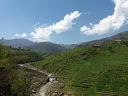
Battagram (Urdu: بٹگرام, Pashto: بټګرام) is the capital city of Battagram District in Khyber Pakhtunkhwa Province of Pakistan. It is located at 34°41'N 73°1'E and has an altitude of 1038 metres (3408 feet).[2]
Battagram | |
|---|---|
 Battagram | |
| Coordinates: 34°41′N 73°1′E | |
| Country | |
| Province | Khyber Pakhtunkhwa |
| District | Battagram |
| Elevation | 1,038 m (3,406 ft) |
| Population | |
| • Total | 27,083 |
Climate
With a mild and generally warm and temperate climate, Battagram features a humid subtropical climate (Cfa) under the Köppen climate classification. The average temperature in Battagram is 18.5 °C, while the annual precipitation averages 1218 mm. Even in the driest months, there is a lot of precipitation. November is the driest month with 28 mm of precipitation, while July, the wettest month, has an average precipitation of 229 mm.
June is the hottest month of the year with an average temperature of 27.9 °C. The coldest month, January, has an average temperature of 7.6 °C.
| Climate data for Battagram | |||||||||||||
|---|---|---|---|---|---|---|---|---|---|---|---|---|---|
| Month | Jan | Feb | Mar | Apr | May | Jun | Jul | Aug | Sep | Oct | Nov | Dec | Year |
| Average high °C (°F) | 12.8 (55.0) |
14.8 (58.6) |
19.6 (67.3) |
24.6 (76.3) |
30.0 (86.0) |
35.1 (95.2) |
33.3 (91.9) |
31.5 (88.7) |
30.6 (87.1) |
27.0 (80.6) |
21.6 (70.9) |
15.2 (59.4) |
24.7 (76.4) |
| Daily mean °C (°F) | 7.6 (45.7) |
9.4 (48.9) |
13.8 (56.8) |
18.5 (65.3) |
23.1 (73.6) |
27.9 (82.2) |
27.2 (81.0) |
26.0 (78.8) |
24.4 (75.9) |
19.8 (67.6) |
14.7 (58.5) |
9.5 (49.1) |
18.5 (65.3) |
| Average low °C (°F) | 2.4 (36.3) |
4.1 (39.4) |
8.0 (46.4) |
12.4 (54.3) |
16.3 (61.3) |
20.8 (69.4) |
21.2 (70.2) |
20.5 (68.9) |
17.8 (64.0) |
12.7 (54.9) |
7.8 (46.0) |
3.8 (38.8) |
12.3 (54.2) |
| Source: Climate-Data.org[3] | |||||||||||||
Education
| Schools of Batagram | Location | Colleges of Battagram | Location |
|---|---|---|---|
| Al-Ezzah Academy Battagram | Karakoram highway, near Tamai road BattagramBold text | Zahid Public High School & College | Banya Road, Kuzabanda Mira |
| Young Muslim Public High School and College | Near Karakoram Highway Battagram | Young Muslim Public School & College Battagram | Located in the heart of Battagram |
| The Rising Star Public College | N/A | ||
| Al Syed Garden Public High School and College Battagram | Near Vagon Adda Battagram | Sir Syed Institute of Learning and Motivation Battagram | Near Sub-Jail Battagram |
The schools are being built with the help of several NGOs and foreign funds to improve the literacy rate of the people.[4]
2005 earthquake
Battagram was among the areas affected by the earthquake of 8 October 2005, when more than 4,500 people were killed and approximately 35,000 were injured.[5]
Administration
Battagram District is divided into two tehsils, the proper Battagram and Allai (which are Banna, Bateela, Batkul, Biari, Jambera, Pashto, Rashang and Sakargah). Proper Battagram main city is a tehsil and district headquarters and is also one of 20 Union Councils of the District of Battagram.[6]
The Battagram Tehsil is subdivided into 12 Union Councils:[6]
| Union Councils | Union Councils |
|---|---|
| AJMERA | Banian |
| Battagram | Batamori |
| Gijbori | Kuza Banda |
| Paimal Sharif | Peshora |
| Rajdahri | Shumlai |
| Thakot | Trand |
See also
References
- "DISTRICT AND TEHSIL LEVEL POPULATION SUMMARY WITH REGION BREAKUP (BATAGRAM DISTRICT)" (PDF). Pakistan Bureau of Statistics. 3 January 2020. Archived from the original (PDF) on 20 April 2018. Retrieved 5 May 2018.
- Location of Battagram – Falling Rain Genomics
- "Climate: Batgram". Climate-Data.org. Retrieved 15 September 2016.
- Holland builds schools in Battagram, Dawn
- "Educational Institutes in Battagram". Hazara. Retrieved 19 March 2012.
- "Tehsils & Unions in the District of Battagram". National Reconstruction Bureau of Pakistan. Archived from the original on 9 February 2012.
Administrative divisions of Battagram District | ||
|---|---|---|
| Capital | ||
| Tehsils | ||
| Union councils | ||
| Village Councils | ||
