Battle of Brentwood
The Battle of Brentwood was a battle of the American Civil War, occurring on March 25, 1863, in Williamson County, Tennessee.
| Battle of Brentwood | |||||||
|---|---|---|---|---|---|---|---|
| Part of American Civil War | |||||||
| |||||||
| Belligerents | |||||||
|
|
| ||||||
| Commanders and leaders | |||||||
| Edward Bloodgood | Nathan Bedford Forrest | ||||||
| Units involved | |||||||
|
22nd Wisconsin Infantry 33rd Indiana Infantry Regiment 19th Michigan Infantry 1st Division, 1st Cavalry Corps | Forrest's Division | ||||||
| Strength | |||||||
| 400 |
| ||||||
| Casualties and losses | |||||||
| 305 | 6 | ||||||
 Brentwood Location of battle.  Brentwood Brentwood (the United States) | |||||||
Battle
Union Lt. Col. Edward Bloodgood held Brentwood, a station on the Nashville & Decatur Railroad, with 400 men on the morning of March 25, 1863, when Confederate Brig. Gen. Nathan Bedford Forrest, with a powerful column, approached the town. The day before, Forrest had ordered Col. J. W. Starnes, commanding the 2nd Brigade, to go to Brentwood, cut the telegraph, tear up railroad track, attack the stockade, and cut off any retreat.
Forrest and the other cavalry brigade joined Bloodgood about 7:00 am on March 25. A messenger from the stockade informed Bloodgood that Forrest's men were about to attack, and had destroyed the railroad tracks. Bloodgood sought to notify his superiors and discovered that the telegraph lines were cut. Forrest sent in a demand for a surrender under a flag of truce, but Bloodgood refused. Within a half-hour, though, Forrest had artillery in place to shell Bloodgood's position and had surrounded the Federals with a large force. Bloodgood decided to surrender.
Forrest and his men caused considerable damage in the area during this expedition, and Brentwood, Tennessee, on the railroad, was a significant loss to the Federals.
Modern Locations
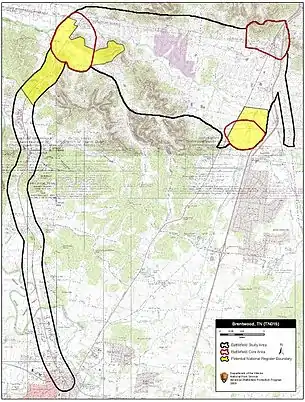
- Johnson Chapel Road, along which General Forrest led his men to battle from the west, has been renamed Maryland Way. The approach would have started at the modern-day intersection of Maryland Way and High Lea Road in the River Oaks subdivision (36.036798, -86.821647). The troops proceeded east to what is now Franklin Road and Church Street (36.033407, -86.788866).[1]
- The other Confederate brigade approaching from the east, under Colonel James Wellborn Starnes, established their position on a nearby hill, currently the Hilton Suites on Church Street (36.032563, -86.780939).[1]
- Most of the battle took place around what is now the Shell station on the northwest corner of Franklin Road and Old Hickory Boulevard (36.038072, -86.787273).[1]
References
- Kelly Gilfillan. "Battle of Brentwood recalled on its 150th anniversary". Brentwood Home Page. Retrieved February 3, 2017.
External links
- Graham, Stacy. "Battle of Brentwood (March 25, 1863)." Tennessee Encyclopedia of History and Culture, accessed December 25, 2014.