Belfort Gap
The Belfort Gap (French: Trouée de Belfort) or Burgundian Gate (German: Burgundische Pforte) is the area of relatively flat terrain between the Vosges Mountains to the north and the Jura Mountains to the south. It marks the watershed between the drainage basins of the River Rhine to the east and the River Rhône to the west, part of the European Watershed between the North Sea and the Mediterranean Sea. It is also the boundary between the historic regions of Burgundy to the west and Alsace to the east, and as such has marked the Franco-German border for long periods of its history.
.jpg.webp)
Geography
Its elevation varies between 345 m (1,132 ft) at its lowest and a little more than 400 m (1,300 ft). The roughly 40 km (25 mi) wide terrain corridor connects the French département of Haut-Rhin, south of the région Alsace and the Territoire de Belfort, north of the région Franche-Comté.[1] The passage allows warm Mediterranean flows to advect northeastwards into the Upper Rhine Plain and the Middle Rhine Valley.
Lines of communication that traverse the Belfort Gap include the French Route nationale 83 and the A36 autoroute, the railway line from Paris to Basel and the planned LGV Rhin-Rhône high-speed railway, as well as the Rhône-Rhine Canal.
History
The Belfort Gap is first recorded as playing a significant military role in 58 BC, when Julius Caesar marched his army through it to confront the Germanic chieftain Ariovistus, whom he defeated at the Battle of the Vosges (probably fought in the vicinity of modern Mulhouse). Over the following decades the whole area west of the Rhine was incorporated into the Roman Empire. The Western Roman Empire collapsed in the 5th century, and in the ensuing Migration Period the Germanic Alemanni settled in the area immediately east of the Belfort Gap, while the Burgundians passed through it and established the Kingdom of the Burgundians to the west. Both Burgundy and Alemannia were conquered by the Kingdom of Francia in the early 6th century, but the Belfort Gap remained the linguistic border between Germanic and Romance languages.
Francia grew to become the Carolingian Empire but then fell apart in the late ninth century, whereupon the Belfort Gap again became a border, this time between East Francia (later the Kingdom of Germany) to the east and the Kingdom of Arles to the west, but by 1033 both kingdoms had been incorporated into the Holy Roman Empire. Thereafter local subdivisions start to become more important, which on the Arlésien side meant the County of Burgundy, and from 1042 also the County of Montbéliard (German: Grafschaft Mömpelgard); the territory on the German side was initially part of the stem duchy of Swabia, later the Alsatian Sundgau.
During the Late Middle Ages the Austrian Habsburg Dynasty acquired first the Sundgau in 1324 and then the County of Burgundy (more usually known in this period as the Franche-Comté) in 1493. The Habsburgs were obliged to cede the Sundgau to the Kingdom of France under the 1648 Peace of Westphalia, and the Belfort Gap therefore became the border between French Alsace and Habsburg Franche-Comté, but not for long as France acquired Franche-Comté too under the 1678 Treaties of Nijmegen.
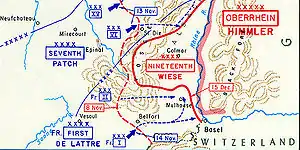
The Belfort Gap acquired renewed significance in the series of Franco-German wars in the nineteenth and early twentieth centuries. During the Franco-Prussian War, the Prussian army invaded France via the Wissembourg Gap and then swept down the length of Alsace and laid siege to Belfort, hoping to seize the city and then rush on through the Belfort Gap into central France. In the event the siege ended up dragging on for months, and an armistice was signed before it could be brought to a decisive conclusion. The wider war had delivered a conclusive result, however, and under the resulting Treaty of Versailles (1871) Alsace and Lorraine were ceded by France to the newly-established German Empire. The language border was used in 1871 to determine the demarcation line between Alsace and Burgundy, and France was thereby able to retain Belfort. It had however become a border town again, and a series of fortifications was therefore thrown up to protect it from any future German attack. At the outbreak of the First World War, French troops invaded Germany through the Belfort Gap, leading to the bloody Battles of the Frontiers. The most recent military advance through the Belfort Gap was that of the French I Corps in November 1944, under General De Lattre.[2]
Notes
- The second main road out of Alsace is the Col de Saverne (Saverne Pass), linking the département of Bas-Rhin (Alsace) to the département Moselle, région Lorraine. Alsace is also accessible via the Tunnel Maurice-Lemaire and some other vosgian passes but they are neither allowed to heavy truck traffic (and dangerous goods in the tunnel) nor equipped with railroads.
- Riviera to the Rhine (U.S. Army in World War II Series), pp. 412-432. Jeffrey J. Clarke and Robert Ross Smith. Washington: Government Printing Office, 1993.
- This article incorporates text translated from the corresponding French Wikipedia article as of November 22, 2008.