Bella Unión
Bella Unión is a city in the north part of Artigas Department of Uruguay.
Bella Unión | |
|---|---|
City | |
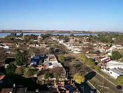 View of the Uruguay River from Bella Unión | |
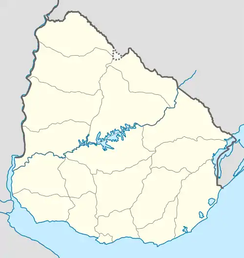 Bella Unión Location in Uruguay | |
| Coordinates: 30°15′0″S 57°35′0″W | |
| Country | |
| Department | |
| Founded | 1829 |
| Founded by | Fructuoso Rivera |
| Population (2011 Census) | |
| • Total | 12,200 |
| Time zone | UTC -3 |
| Postal code | 55100 |
| Dial plan | +598 4779 (+4 digits) |
Location
It is located at the north end of Route 3, on the banks of the Uruguay River, near the mouth of Río Cuareim. Being situated on a piece of land protruding between Argentina and Brazil, it lies across Monte Caseros, Corrientes of Argentina to the west and across Barra do Quaraí of Brazil, which is only 6 kilometres (3.7 mi) to the northeast, joined by a bridge over Río Cuareim.
History
The original settlement was founded on 13 May 1829 under the name "Santa Rosa". It was started by Fructuoso Rivera, who played a prominent role in the early history of Uruguay. On 20 April 1928, it was renamed to "Bella Unión" by the Act of Ley No. 8.207.[1] On 15 October 1963, its status was raised to "Ciudad" (city) by the Act of Ley No. 13.180.[2]
Population
In 2011, Bella Unión had a population of 12,200.[3] Together with its peripheral populated and rural areas (Coronado, Portones de Hierro y Campodónico, Las Piedras, Franquia & Cuareim) they form a population centre of around 18,000.
| Year | Population |
|---|---|
| 1908 | 5,414 |
| 1963 | 4,955 |
| 1975 | 7,778 |
| 1985 | 12,238 |
| 1996 | 13,537 |
| 2004 | 13,187 |
| 2011 | 12,200 |
Source: Instituto Nacional de Estadística de Uruguay[1]
Places of worship
- St. Rose of Lima of the Cuareim Parish Church (Roman Catholic)
Notable local person
The writer Jesús Moraes, (1955-), who specializes in short stories in Spanish, is from Bella Unión, and is one of the relatively few contemporary Uruguayan writers strongly identified with the Uruguayan north.
Climate data
| Climate data for Bella Unión (1980–2009) | |||||||||||||
|---|---|---|---|---|---|---|---|---|---|---|---|---|---|
| Month | Jan | Feb | Mar | Apr | May | Jun | Jul | Aug | Sep | Oct | Nov | Dec | Year |
| Average high °C (°F) | 32.0 (89.6) |
30.5 (86.9) |
29.0 (84.2) |
25.0 (77.0) |
21.5 (70.7) |
19.0 (66.2) |
18.6 (65.5) |
21.2 (70.2) |
22.7 (72.9) |
25.5 (77.9) |
27.9 (82.2) |
29.7 (85.5) |
25.2 (77.4) |
| Daily mean °C (°F) | 26.0 (78.8) |
24.9 (76.8) |
23.7 (74.7) |
20.0 (68.0) |
16.5 (61.7) |
14.4 (57.9) |
13.6 (56.5) |
15.4 (59.7) |
17.1 (62.8) |
20.1 (68.2) |
22.0 (71.6) |
24.2 (75.6) |
19.8 (67.6) |
| Average low °C (°F) | 20.1 (68.2) |
19.4 (66.9) |
18.3 (64.9) |
14.9 (58.8) |
11.6 (52.9) |
9.8 (49.6) |
8.7 (47.7) |
9.6 (49.3) |
11.4 (52.5) |
14.8 (58.6) |
16.2 (61.2) |
18.7 (65.7) |
14.5 (58.1) |
| Average precipitation mm (inches) | 141.4 (5.57) |
144.4 (5.69) |
145.9 (5.74) |
175.6 (6.91) |
109.1 (4.30) |
90.1 (3.55) |
55.3 (2.18) |
55.4 (2.18) |
96.9 (3.81) |
151.0 (5.94) |
150.9 (5.94) |
132.8 (5.23) |
1,448.8 (57.04) |
| Average relative humidity (%) | 65 | 69 | 72 | 76 | 77 | 79 | 76 | 71 | 69 | 68 | 66 | 64 | 71 |
| Mean monthly sunshine hours | 297.6 | 245.8 | 244.9 | 186.0 | 189.1 | 162.0 | 176.7 | 192.2 | 204.0 | 241.8 | 267.0 | 300.7 | 2,707.8 |
| Mean daily sunshine hours | 9.6 | 8.7 | 7.9 | 6.2 | 6.1 | 5.4 | 5.7 | 6.2 | 6.8 | 7.8 | 8.9 | 9.7 | 7.4 |
| Source: Instituto Nacional de Investigación Agropecuaria[4] | |||||||||||||
References
- "Statistics of urban localities (1908–2004) (see also Santa Rosa)". INE. 2012. Archived from the original (PDF) on 23 March 2015. Retrieved 3 September 2012.
- "LEY N° 13.180". República Oriental del Uruguay, Poder Legislativo. 1963. Archived from the original on 6 March 2016. Retrieved 28 June 2011.
- "Censos 2011 Cuadros Artigas". INE. 2012. Archived from the original on 10 October 2012. Retrieved 25 August 2012.
- Castaño, José; Giménez, Agustín; Ceroni, Mauricio; Furest, José; Aunchayna, Rossina. "Caracterización Agroclimática del Uruguay 1980–2009" (PDF) (in Spanish). Instituto Nacional de Investigación Agropecuaria. Retrieved December 13, 2015.
External links
| Wikimedia Commons has media related to Bella Unión. |
| Wikivoyage has a travel guide for Bella Unión. |
- es:Fructuoso Rivera
- INE map of Bella Unión, Coronado, Las Piedras and Portones de Hierro y Campodónico
- The Community Website
Capital: Artigas | ||
| Towns and villages |  | |
| Sights | ||