Benedikt, Benedikt
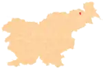
Benedikt (pronounced [bɛnɛˈdiːkt]) is the central settlement in the Municipality of Benedikt in northeastern Slovenia. Before 1998, it was part of the Municipality of Lenart. It lies in the Slovene Hills (Slovene: Slovenske gorice). The area is part of the traditional region of Styria. It is now included in the Drava Statistical Region.[3]
Benedikt
Sveti Benedikt v Slovenskih Goricah (until 1952), Benedikt v Slovenskih Goricah (until 2003) | |
|---|---|
 | |
 Coat of arms | |
 Benedikt Location of Benedikt in Slovenia | |
| Coordinates: 46°36′23.23″N 15°53′2.99″E | |
| Country | |
| Traditional region | Styria |
| Statistical region | Drava |
| Municipality | Benedikt |
| Area | |
| • Total | 5.971 km2 (2.305 sq mi) |
| Elevation | 253 m (830 ft) |
| Population (2016)[2] | |
| • Total | 1,078 |
| • Density | 181/km2 (470/sq mi) |
Name
The name of the settlement was changed from Sveti Benedikt v Slovenskih Goricah (Slovene: Sveti Benedikt v Slovenskih goricah; literally, 'Saint Benedict in the Slovene Hills') to Benedikt v Slovenskih Goricah (Benedikt v Slovenskih goricah; literally, 'Benedict in the Slovene Hills') in 1952. The name was changed on the basis of the 1948 Law on Names of Settlements and Designations of Squares, Streets, and Buildings as part of efforts by Slovenia's postwar communist government to remove religious elements from toponyms.[4][5][6] In 2003, it was changed simply to Benedikt.[7]
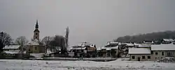
Church
The local parish church from which the village gets its name is dedicated to Saint Benedict and belongs to the Roman Catholic Archdiocese of Maribor. It is originally a Gothic church dating to the second quarter of the 14th century. It was extensively rebuilt in the 18th and 19th centuries.[8]
References
- "Nadmorska višina naselij, kjer so sedeži občin" [Height above sea level of seats of municipalities] (in Slovenian and English). Statistical Office of the Republic of Slovenia. 2002. Archived from the original on 2006-11-30.
- "Benedikt, Benedikt". Place Names. Statistical Office of the Republic of Slovenia. Retrieved 2 March 2017.
- Benedikt municipal site
- Spremembe naselij 1948–95. 1996. Database. Ljubljana: Geografski inštitut ZRC SAZU, DZS.
- Premk, F. 2004. Slovenska versko-krščanska terminologija v zemljepisnih imenih in spremembe za čas 1921–1967/68. Besedoslovne lastnosti slovenskega jezika: slovenska zemljepisna imena. Ljubljana: Slavistično društvo Slovenije, pp. 113–132.
- Urbanc, Mimi, & Matej Gabrovec. 2005. Krajevna imena: poligon za dokazovanje moči in odraz lokalne identitete. Geografski vestnik 77(2): 25–43.
- "Benedikt". Geostatistični portal: Krajevna imena [Geostatistical Portal: Place Names] (in Slovenian). Statistical Office of the Republic of Slovenia. Retrieved 16 April 2012.
- Slovenian Ministry of Culture register of national heritage reference number ešd 1068
External links
- Benedikt. A map and basic data. Geopedia.si (V1). Retrieved 13 March 2012.
 Media related to Benedikt at Wikimedia Commons