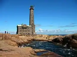
Bengtskär
Bengtskär is an island 25 kilometres (16 mi) southwest of Hanko, and part of the municipality of Dragsfjärd. This rocky island can be reached by ferry from the village of Kasnäs. The island has an area of about two hectares,[1] and only a small part of it is covered with vegetation, the rest is a naked granite.
 The Bengtskär Lighthouse is a popular tourist attraction | |
| Geography | |
|---|---|
| Location | Gulf of Finland, Archipelago Sea |
| Coordinates | 59°43′23″N 22°29′56″E |
| Archipelago | Turku |
| Area | 002 km2 (0.77 sq mi)[1] |
| Administration | |
| Province | Southwest Finland |
| Demographics | |
| Population | 1 |
| Additional information | |
| Official website | www |
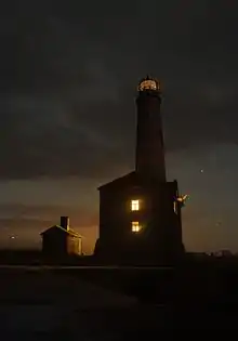
The Bengtskär Lighthouse on the skerry is the highest one in the Nordic countries, with a tower height of (46 m or 151 ft).[2] The lighthouse is owned by the Foundation of the University of Turku. Annually the island attracts over 13,000 tourists.[3]
On 26 July 1941, during the Continuation War Soviet troops attempted to capture and blow up the lighthouse, but the Finnish garrison managed to repel the attack. The lighthouse was not destroyed but damaged.[4]
See also
References
- "Archived copy" (PDF). Archived from the original (PDF) on 15 July 2015. Retrieved 4 May 2015.CS1 maint: archived copy as title (link) Elina Auri. Ilman kiinteää tieyhteyttä olevat pysyvästi asutut saaret. (fi) Retrieved 4 May 2015.
- "Lighthouses of Southern Finland". www.unc.edu. The University of North Carolina at Chapel Hill. Archived from the original on 2 October 2015. Retrieved 4 May 2015.
- Tiesitkö: Tämä on erikoisin paikka, missä Suomi ja Neuvostoliitto sotivat. Archived 5 May 2015 at the Wayback Machine Studio55.fi Retrieved 4 May 2015.
- "History". www.bengtskar.fi. Archived from the original on 20 July 2011. Retrieved 4 May 2015.
