Benten-jima (Wakkanai)
Benten-jima (弁天島) is a small deserted island west by northwest of Cape Sōya, Wakkanai, Hokkaidō, Japan. It is the northernmost piece of land under Japanese control. The island is 1 km north of Sannai settlement. Another island called Hira-shima (平島) lies southeast of Benten-jima.
| Native name: 弁天島 | |
|---|---|
 | |
 Benten-jima | |
| Geography | |
| Location | La Pérouse Strait |
| Coordinates | 45°31′35″N 141°55′09″E |
| Area | 0.005 km2 (0.0019 sq mi) |
| Coastline | .5 km (0.31 mi) |
| Highest elevation | 20 m (70 ft) |
| Highest point | unnamed point |
| Administration | |
Japan | |
| Prefectures | Hokkaido |
| Subprefecture | Sōya |
| City | Wakkanai |
| Demographics | |
| Population | 0 |
Benten-jima is 0.005 square kilometres (0.0019 sq mi) in area, its perimeter is roughly 0.5 kilometres (0.31 mi), and its highest point is 20 metres (66 ft) above sea level. It is named after Benzaiten, once enshrined on the island. The wildlife includes many seabirds, Steller sea lions, kombu kelp, and sea urchins; it has been recognised as an Important Bird Area (IBA) by BirdLife International because it supports a large breeding colony of black-tailed gulls.[1]
Photos
 Aerial photo of Benten-jima from the Geospatial Information Authority of Japan
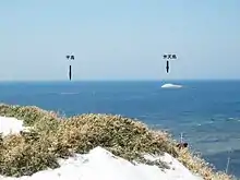 Benten-jima (弁天島) and Hira-shima (平島) seen from Cape Sōya
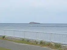 Benten-jima, viewed from Cape Sōya
See also
- Geography of Japan
- Japanese Archipelago
- Extreme points of Japan
- Desert island
- List of islands
References
- "Bentenjima islet". BirdLife Data Zone. BirdLife International. 2021. Retrieved 25 January 2021.
External links
- (in Japanese) 宗谷岬弁天島におけるトド調査始まる (The survey of Steller sea lions has begun on Bentenjima Island, Cape Sōya), from マリンネット北海道 (Marine Net Hokkaidō).
This article is issued from Wikipedia. The text is licensed under Creative Commons - Attribution - Sharealike. Additional terms may apply for the media files.